Conceptual Diagrams Can Get You Places
Bill Nuttle ·'Scientists who made a difference' series
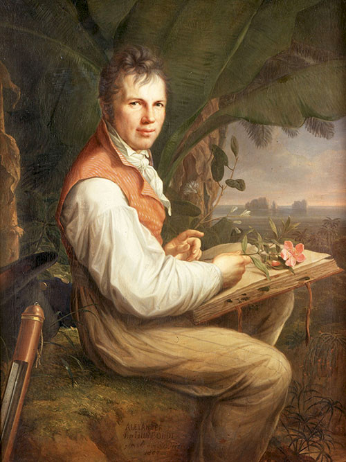
Alexander von Humboldt became world famous by illustrating how nature works.
If you ever get to Humboldt, Nebraska (40°9′54″N 95°56′45″W) you will have gotten someplace special. Humboldt lies almost exactly at the geographic center of the Mississippi River watershed; motto: “Heartbeat of the Heartland.” It is also one of about two dozen places in the US named in honor of a 19th century Prussian aristocrat and darling of Parisian salons. The story of how Alexander von Humboldt came to be acclaimed in America revolves around his career as scientist and explorer and especially Humboldt’s innovative use of conceptual diagrams.
Friedrich Wilhelm Heinrich Alexander von Humboldt, born in Berlin in 1769, was educated with the ideals of the European Enlightenment. Initially intending on a career in politics and administration, Humboldt’s interests lead him into the study of geology and astronomy. Humboldt's role in the history of science was to combine the descriptive approach of geology and the quantitative approach of astronomy through the extensive use of measurements by various instruments in his exploration and description of nature.

Humboldt was fortunate to be one of the first scientific explorers of the new world. Humboldt teamed up with Aimé Bonpland, a French botanist, to conduct an expedition to the tropics of the Caribbean, the northern part of South America, Central America and Mexico. This area was largely unknown to Europeans in spite of centuries of colonial rule because of the secretive nature of the Spanish empire. Humboldt and Bonpland were among the first non-Spanish Europeans, and almost certainly the first trained scientists, to visit this region. This generated a great deal of interest in their expedition.
Humboldt and Bonpland spent 5 years, 1799-1804, bushwhacking through jungles, fording rivers, and climbing mountains. They reached a record elevation of 19,286 feet, nearly to the summit of Chimborazo, a stratovolcano in Ecuador, thought at that time to be the tallest mountain in the world. All the while, Humboldt and Bonpland took detailed measurements of everything they could imagine. Humboldt had prepared well for his scientific investigations. Reportedly, the crates of the finest instruments packed in velvet-lined cases, required a team of 30 pack mules to transport.
After returning to Europe, Humboldt settled in Paris to write up his results, a task he expected would take the next 2 years but ended up taking 20. The main concept underlying Humboldt’s studies was that conditions in nature are determined by a balance between opposing forces. He hoped to use the vast amount of data that he and Bonpland collected to describe the interplay between forces largely hidden from the casual observer, but that his instruments could reveal. Humboldt’s fame grew. He had interesting stories to tell, and he told them well.

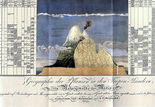
Humboldt pioneered the use of conceptual diagrams. Perhaps his best known diagram is one that illustrates the vertical zonation of vegetation on the flanks of the Chimborazo volcano. The diagram presents a schematic representation of the underlying geology drawn in section-view through the mountain and extending out to the edge of the continent. The layered structure of the atmosphere and ocean are shown, with the different types of clouds at their proper elevation. The zonation in vegetation with elevation is sketched on the side of the mountain. Tables on either side of the diagram summarize changes in temperature, pressure, solar radiation, the boiling point of water, gravity (sensed by changes in the period of a pendulum), etc., all keyed to elevation. Humboldt’s preference for using diagrams, rather than the dry mathematics favored by the preeminent astronomers of his day, undoubtedly accounted for his broad appeal.
Humboldt’s connection to America began with the end of his South American expedition. On his return to Europe in 1804, Humboldt spent several months visiting with President, Thomas Jefferson, and officials of the federal government. Jefferson had just negotiated the purchase of the Louisiana Territory, consisting of the western portion of the Mississippi River basin, and the young nation had it sights set on the Spanish-held territory to its south. Humboldt had gathered valuable information in his research and from his travels in Mexico. He could tell the Americans who and what lay in the largely unmapped territory west of the Mississppi River. Humboldt flattered his hosts with his open enthusiasm for the New World and the American experiment. During this visit Humboldt established personal contacts, which he nurtured over the rest of his career encouraging the men who launch the westward expansion of the US.
By the middle of the 19th century Humboldt was one of the most famous men in Europe and in America. He was the prototypical scientist of his day, as Einstein was in the 20th century. Several generations of scientists sought to emulate him, and he gave generously of his time in supporting the careers of younger scientists. Charles Darwin patterned his voyage of discovery on the Beagle after Humboldt's expeditions. Humboldt’s influence extended beyond science; Henry David Thoreau based his environmentalist philosophy on Humboldt’s view of nature. For Europeans, Humboldt revealed a strange new world. For Americans looking westward, he charted the path of scientific exploration of the vast areas of North America that were still unknown. That’s how Humboldt got his name on towns in Nebraska, Iowa, Kansas, and Tennessee, and on a river in Nevada, a mountain in Arizona, a bay on the coast of California and dozens of other places in the North America (Walls 2001).
*******
Alexander von Humboldt did not have access to the tools available to science communicators today, and that limited what he could do. For example, faced with the task of painstakingly engraving symbols to represent different vegetation communities on his conceptual diagram of Chimborazo, he chose instead to use text labels. Today, Humboldt would have access to a wealth of symbols freely available from the IAN online symbol library. Just think of all the places you might get by using this resource.
Reference
Walls, L. D., 2001. "Hero of Knowledge, Be Our Tribute Thine:" Alexander von Humboldt in Victorian America. Northeastern Naturalist Vol. 8, Special Issue 1: Alexander von Humboldt's Natural History Legacy and Its Relevance for Today (2001), pp. 121-134.