Laguna de Bay, Philippines: Environmental Literacy
Vanessa Vargas-Nguyen ·‘Environmental literacy‘ series
As part of the Integration and Application Network’s collaboration with the Partnerships in Environmental Management for the Seas of East Asia Resource Facility (PRF) and the Laguna Lake Development Authority (LLDA) in the development of an Ecosystem Health Report Card for Laguna de Bay, the seven environmental literacy for Laguna de Bay are listed:
- Laguna de Bay is the largest fresh water lake in the Philippines, and the third largest in South East Asia.
- The only outlet of Laguna de Bay is the Pasig River, which connects the lake to Manila Bay.
- Laguna de Bay is a major source of fisheries in the Philippines.
- Laguna de Bay supports multi-use.
- Uncontrolled development, population growth, and industrialization are a major threat to Laguna de Bay.
- The Laguna de Bay region is rich in history, natural beauty, and biodiversity.
- The Laguna de Bay region is managed through the Laguna Lake Development Authority (LLDA).
The Seven Environmental Literacy for Laguna de Bay, Philippines:
1. Laguna de Bay is the largest fresh water lake in the Philippines, and the third largest in South East Asia. The lake has a surface area of 911-949 km² (352-366 sq mi), with an average depth of about 2.8 metres (9 ft 2 in) and an elevation of about 1 metre (3 ft 3 in) above sea level. It is one of the primary freshwater sources in the Philippines and is fed by 45,000 km2 (17,000 sq mi) of catchment areas. It has 21 tributaries in total, the largest is the Pagsanjar River, which is the source of 35% of its water and the Santa Cruz River which is the source of 15% of its water. Other important rivers are the Balanak, Marikina, Mangangate, Tunasan and San Pedro.
Laguna de Bay is bordered by the province of Laguna in the east, west and southwest, the province of Rizal in the north to northeast, and Metro Manila in the northwest. The lake features three distinct bays, the West Bay, Central Bay and East Bay that diverges to the South (South Bay). The West Bay watershed is the most populated and heavily developed, mainly because it includes part of Metro Manila, while the East Bay is the least populated. The West and Cenral By is separated by Talim Island, the biggest and most populated island within the Lake.
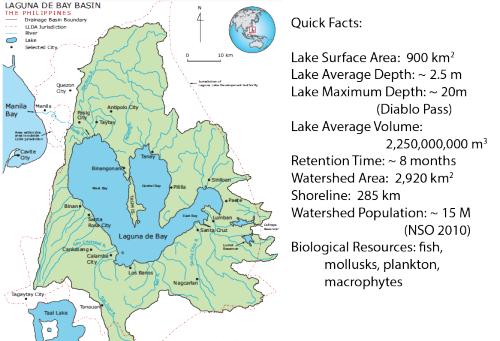
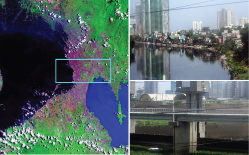
2. The only outlet of Laguna de Bay is the Pasig River, which connects the lake to Manila Bay. Pasig River is considered a tidal estuary, the river's flow direction is dependent on the tides especially during dry season when the water level in Laguna de Bay may drop below that of Manila Bay's. This would result to a reverse flow of seawater from the bay into the lake, increasing the pollution and salinity levels of the lake at this time of the year. During wet season, the flow is reversed towards Manila Bay.
The Manggahan Floodway was constructed to reduce the flooding of the Pasig River. Excess floodwater is diverted from the river into Laguna de Bay, which serves as a temporary reservoir. The Napindan Hydraulic Control System (NHCS) was built to regulate the flow of water between the Pasig River and the lake, it is located at the confluence of the Marikina River (a tributary of Pasig River) and the Napindan Channel.
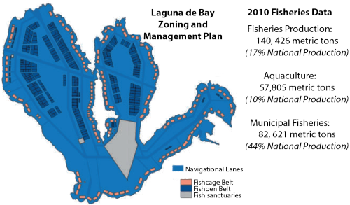
3. Laguna de Bay is a major source of fisheries in the Philippines. Laguna de Bay accounts for 17% of the national fisheries production, 10% of the national production for aquaculture and 44% of the national production for municipal fisheries. However, large-scale fishpens have threatened the economic conditions of fishermen dependent upon open water fishery. Illegal fishing activities and increased aquaculture operations also led to declining harvest due to depletion of natural resources. Increase of invasive fish species are also observed. There is also excessive snail dredging to support the duck raising industry. Crustaceans and mollusks declined in yield from 1,927 to 574 MT and from 101,101 to 85,363 MT respectively, in 1997-2000. To address the issue, a revised Lake Fishery Zoning and Management Plan was implemented in 1996.
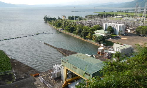
4. Laguna de Bay supports multi-use. The lake represents a major transportation route between the towns and cities lying on its shores. More than 5,000 motorized and non-motorized watercraft operate as a means of transportation for lakeshore communities. In addition, an average of 75,640 barrels of oil and oil products are transported to various supply depots daily by barges plying the lake. Laguna de Bay is also used for power generation; three power plants are located in the region. It is an important source of water for the Kalayaan Pumped Storage Hydroelectric Project. It also provides irrigation water for the farm lands and is also being used as a source of industrial cooling water. Water permit for Manila Water Services Inc. (MWSI) has been approved in July 2009 to abstract a maximum volume of 300,000 cubic meters/day for domestic use.
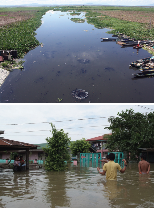
5. Uncontrolled development, population growth, and industrialization are a major threat to Laguna de Bay. The lake serves as a huge waste sink for solid and liquid waste coming from households, cropland areas, industries, livestock and poultry production as well as fishery activities. Pollution is carried as surface run-off through the sub-basins of the lake. In addition, polluted waters from the Marikina and Pasig Rivers also flow into the lake. Over 60% of the 15 million inhabitants of the lake area dump their domestic waste into either the lake or its many tributaries. Forty percent of this waste is made up of agricultural elements, 30% is domestic and the remaining 30% industrial waste.
Quarry operations and limestone extraction caused denudation of the forest and siltation of the lake and its tributary rivers in the Rizal province area. Water pollution and eutrophication are major environmental concern especially in the West Bay. Flooding in the region is not only limited to the Metro Manila area especially during strong typhoon.
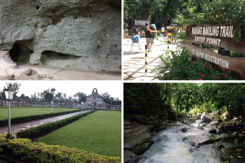
6. The Laguna de Bay region is rich in history, natural beauty, and biodiversity. The Laguna de Bay lakeshore has been inhabited for many thousands of years, which can be seen in the Angono petroglyphs in the lakeshore town of Binangonan, Rizal. Due to the many years of Spanish influence, there are several old churches around the region. One of the most unusual is the Nagcarlan Underground Cemetery.
The lake is also part of the flyway for migratory birds. Mount Makiling National Park is located south of the lake. The mountain is ideal for hiking, camping, trekking, mountain biking, and bird watching. The Mount Makiling Forest Reserve has a total of 2048 plant species, many of which are exotic flowers.
7. The Laguna de Bay region is managed through the Laguna Lake Development Authority (LLDA). It is the only lake in the Philippines managed by a special agency of the Philippines government. LLDA was formed in 1966 to institute an organized system of lake usage regulations. Its mission is "to catalyze a climate change-sensitive Integrated Water Resource Management in the Laguna de Bay Region, with clear focus on preserving ecological integrity and promoting sustainable economic growth" (LLDA Mission statement). LLDA develops and enforces environmental management, water quality monitoring, conservation of natural resources, and community-based natural resource management. It enforces the licensing of fish pens and cages and the environmental user fee system. They work with municipalities to control and treat both industrial and household waste, and help to determine how much water can be withdrawn for what purpose.
The vision of LLDA is that by 2020, the Laguna de Bay Basin has been transformed as the focal center for sustainable development through sound ecological governance.

References:
Santos-Borja, Adelina and Dolora Nepomoceno. 2006. Laguna de Bay: Experiences and Lesson Learned Brief. [pdf]
Laguna Lake Development Authority Website
Wikipedia.org
About the author
Vanessa Vargas-Nguyen

Dr. Vanessa Vargas-Nguyen is a Science Integrator with the Integration and Application Network and an associate faculty of the Marine Estuarine and Environmental Science Graduate Program. Her current interest is in transdisciplinary approaches, socio-environmental assessments, socio-environmental justice, stakeholder engagement, and adaptive environmental governance. Vanessa is originally from the Philippines and has extensive experience in molecular biology and marine science, specializing in microbial communities and molecular processes associated with Harmful Algal Blooms and shrimp, corals, and human diseases. She has since shifted her focus on how science can benefit society and was conferred with the first Ph.D. under the new Environment and Society foundation of the MEES graduate program. Her dissertation used ethnographic approaches to investigate the role of socio-environmental report cards in transdisciplinary collaboration and adaptive governance for a sustainable future. She received academic training from the University of the Philippines (BSc; MSc) and the University of Maryland (MSc; PhD). She is involved in developing holistic socio-environmental assessments for complex systems such as the Mississippi River and Chesapeake Bay watersheds and is coordinating a multi-year international transdisciplinary research consortium involving the US, Norway, Philippines, Japan, and India.
Next Post > Development of an Ecosystem Health Report Card for Laguna de Bay, Philippines
Comments
-
Kelvin Rodolfo 8 years ago
What are your opinions about the Laguna Lake Expressway Dike?
-
Danilo Salgados 8 years ago
I think the residents around laguna de bay should act accordingly with the support of some specialized agencies not to abuse the lake otherwise their son sons will pay the price.
-
Volcano Damavand 7 years ago
I'm amazed, I must say. Rarely do I encounter
a blog that's both equally educative and engaging, and let me tell you, you have hit the nail on the head.
The issue is something that not enough men and women agree
speaking intelligently about. I am very happy that I stumbled
across this in my search for something regarding this. -
Stephen Barres 5 years ago
During highschool days, A teacher once told our class that "de Bay" from Laguna de Bay is from a foreign scientist's Surname who did some research of the lake.How true is that?
-
Atika 3 months ago
Thank you for sharing this great information with us, i really appreciate your post!