

Maryland Coastal Bays Report Card 2009
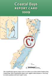 The aim of this report card is to provide a transparent, timely, and geographically detailed assessment of 2009 Coastal Bays health. Coastal Bays health is defined as the progress of four water quality indicators (TN, TP, Chl a, DO) and two biotic indicators (seagrass, hard clams) toward scientifically derived ecological thresholds or goals. The six indicators are combined into one overarching Coastal Bays Health Index, which is presented as the report card score. Detailed methods are available at https://ecoreportcard.org/report-cards/maryland-coastal-bays/health/. The overall score for the Coastal Bays was a C+ in 2009. While the northern bays and western tributaries continue to struggle, there are signs of improvement in some areas. However, the southern bays—historically the more pristine of the Coastal Bays—are showing signs of degradation.
Chesapeake Bay Forecast 2010
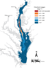 For the past several years, Chesapeake Bay scientists have collaborated with EcoCheck (NOAA-UMCES partnership) to forecast Chesapeake Bay summer dissolved oxygen and harmful algal blooms conditions, weeks in advance, based on flow and nutrient loading conditions through May. For 2010, ecological forecasts were generated for early summer summer (June to mid-July) and late summer (mid-July to September) anoxia, July hypoxia, and July plus August hypoxia. These forecasts are generated by different Chesapeake Bay researchers and use different methods than in the past. The anoxic condition (no dissolved oxygen) in the Bay's mainstem is predicted to be moderately poor this summer. All the dissolved oxygen forecasts for this summer are for a smaller than usual region of low oxygen water. This anoxia forecast will be updated in mid-summer to provide the late summer anoxia forecast, so check back in July!
Working with Pacific Island National Parks
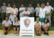 Tim Carruthers and Jane Hawkey from IAN recently continued work with the US National Park Service (NPS) Inventory and Monitoring program (I&M) in the Pacific Island Network (PACN) to develop communications products related to Park natural resources. Resulting products will be a two-page flyer summarizing some of the key features and cultural links with the National Park of American Samoa, a poster considering some of the marine natural resource considerations associated with the USS Arizona memorial at WWII Valor in the Pacific National Monument, and a two-page flyer summarizing groundwater processes and potential stressors surrounding Kaloko-Honokohau National Historical Park.
Communicating corals and climate change in the Pacific Islands
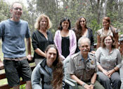 Earlier this month IAN and COSEE Coastal Trends staff, in partnership with the National Park Service Pacific Island Network, launched the coral reef and climate change scientist-educator team. The team, based in Volcano, Hawai'i, will draw on the diverse skills and backgrounds of its members to create informative and engaging materials that communicate the unique features of coral reefs within the Pacific Island Network. Team members, from across the Pacific Islands of Hawai'i and American Samoa, represent the University of Hawai'i at Hilo, the Pacific Internship Programs for Exploring Science, and Kahuku High School. Over the course of six weeks, the team will design hands-on and virtual activities, create conceptual diagrams, and develop classroom lesson plans that draw on traditional knowledge and current NPS research.