

Video & Blog Highlights
Video
- Douglas Moyer, of the US Geological Survey, presented the latest Science for Citizens seminar in two parts. Part one was titled "USGS Watershed Monitoring Results" and part two was titled "USGS River Input Monitoring Results". The videos can be viewed on IAN's website or YouTube (part one here, part two here).
Blogs
- A new style of conceptual cross section diagrams developed for New York Harbor
- How environmental report cards can democratize science
- Data visualization: Feng shui for your charts, graphs, and plots
A Look Inside New York Harbor poster released for classroom use
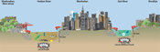 IAN released a new poster titled "A Look Inside NY Harbor" for use in classrooms. The poster is available on IAN's website and is an offshoot from the Billion Oyster Project. IAN Science Communicator Brianne Walsh developed a series of four conceptual diagrams for this poster which illustrate the complex waterways, urban development, and iconic structures of New York Harbor. These cross-sectional diagrams transect the land and waterways at well-known locations such as the George Washington Bridge and the Statue of Liberty. The diagrams highlight natural features such as fish habitat or sediment type, the location of infrastructure such as the Brooklyn Battery Tunnel, as well as cities and boroughs.
IAN kicks off collaboration with Cambodian Ministry of Environment on Mekong Flooded Forest Landscape Report Card
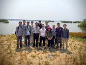 In March 2016, Brianne Walsh and Simon Costanzo travelled to Kratie Province in Cambodia to continue our collaboration with the Luc Hoffmann Institute and World Wildlife Fund - Freshwater for the Linked Indicators For Vital Ecosystem Services (LIVES) project. This trip was part of a series of training sessions held in Cambodia aimed equipping a group of Ministry of Environment (MoE) staff with facilitation and technical skills to undertake workshops and ultimately develop a report card for the Mekong Flooded Forest Landscape. After three days of training, the MoE staff ran a day-long workshop with a group of local farmers to identify coping strategies to future climate scenarios; and a day-long workshop for provincial stakeholders identifying potential report card indicators.
Texas coast pilot project workshop creates EcoHealth Metrics
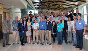 The Harte Research Institute for Gulf Studies at Texas A&M recently hosted a workshop to restart the creation of a Gulf of Mexico Report Card. The project will be initiated by creating eco-health metrics for the Texas coast which will then be scaled up to the entire, and vast, Gulf of Mexico watershed. A vision for the Gulf of Mexico Report Card was created in 2013 and will be used as a framework for this Texas Coast pilot project.
OysterFutures project underway
 A collaborative project to develop consensus on recommendations for oyster fishing practices and restoration in the Choptank and Little Choptank rivers kicked off at its first meeting Feb. 26 and 27 at the University of Maryland Center for Environmental Science's Horn Point Laboratory. The new undertaking, OysterFutures, is a five-year project funded by the National Science Foundation with a goal of bringing a diverse group of stakeholders together from the oyster industry, environmental groups, and government agencies to make recommendations on ways to improve the oyster resource while integrating commercial and restoration interests. Jane Thomas from IAN is assisting with organizing the workgroup meetings and communicating the results to a wide audience.
On the Horizon
- Join the conversation with IAN on Twitter 19 April and 3 May using #IANCoastalChange. Follow @IANEcocheck for more information.
- OysterFutures workgroup meeting is taking place 30 April- 1 May.
- The National Water Quality Monitoring Conference is being held in Tampa, Florida 2-6 May 2016.