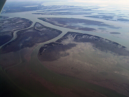
A collection of images for use in science communication with a focus on Chesapeake Bay and its watershed


Home :: Register :: FAQ :: Login
Browse All :: Album list :: Last uploads :: Last comments :: Most viewed :: Most downloaded :: Top rated :: Lightbox :: Advanced Search

Install the IAN Image and Video Library Browser Sidebar for easier navigation and searching.
Image & Video Library Guide - Contains a list of instructions on navigating, uploading and downloading files.
Home > Specific Projects > Coastal Louisiana > Aerial / Satellite
Wax Lake Diversion
Natural sediment deposition at the Wax Lake Diversion in coastal Louisiana

Wax Lake Diversion Natural sediment deposition at the Wax Lake Diversion in coastal Louisiana sea level rise clear geomorphology hurricane mud flat coastal erosion

High Resolution Image (4144 KB) only available for download by registered users (FREE!) - Login or Register Now (Free, Quick & Easy!)

 
Wax Lake Diversion
Natural sediment deposition at the Wax Lake Diversion in coastal Louisiana
Degrading wetlands in coastal Louisiana Due to land subsidence and sea level rise, rapid wetland loss starts as wetland breakup and increase in open water hurricane coastal processes coastal erosion geomorphology mud flat Atchafalaya River mouth Mouth of the Atchafalaya River, coastal Louisiana geomorphology clear coastal processes hurricane coastal erosion Wax Lake Diversion Natural sediment deposition at the Wax Lake Diversion in coastal Louisiana sea level rise clear geomorphology hurricane mud flat coastal erosion Oil rig Oil rig in coastal Louisiana clear coastal Louisiana gas oil Port Fourchon development industry Coastal Community in degrading wetland Coastal Community in degrading wetland in coastal Louisiana      coastal Louisiana clear coastal processes sea level rise
Rate this file (current rating : 0 / 5 with 1 votes)
Rubbish
Poor
Fair
Good
Excellent
Great
File information
Filename:ill-ian-tc-0143.jpg
Album name:tcarruth / Aerial / Satellite
Rating (1 votes):
Keywords:sea level rise clear geomorphology hurricane mud flat coastal erosion
Photographer's Name:Tim Carruthers
Photographer's Company:IAN, UMCES
Date Photo was taken (MM/DD/YYYY):11/19/2005
Media Type (Photo, Satellite Image, Vector Graphic, Map, Animation, Video):Photo
File Size:4144 KB
Date added:Sep 01, 2006
Dimensions:2048 x 1536 pixels
Displayed:135 times
Downloaded:3 times
Image Description:Natural sediment deposition at the Wax Lake Diversion in coastal Louisiana
Color Space:sRGB
Components Configuration:YCbCr
Compressed Bits Per Pixel:4
Contrast:0
Customer Render:0
Date Time:2006:09:01 15:17:35
DateTime Original:2005:11:19 12:32:11
DateTime digitized:2005:11:19 12:32:11
Digital Zoom Ratio:0
Exif Image Height:1536 pixels
Exif Image Width:2048 pixels
Exif Interoperability Offset:1072
Exif Offset:436
Exif Version:version 2.2
Exposure Bias:0 EV
Exposure Mode:0
Exposure Program:Program
Exposure Time:1/167 sec
FNumber:f 5.6
File Source:Digital Still Camera
Flash:No Flash
Flash Pix Version:version 1
Focal length:5.8 mm
Gain Control:0
ISO:100
Light Source:Unknown or Auto
Make:NIKON
Max Aperture:f 2.8
Metering Mode:Multi-Segment
Model:E3100
Orientation:Normal (O deg)
Resolution Unit:Inch
Saturation:0
Scene Capture Mode:0
Scene Type:Directly Photographed
Sharpness:0
Software:Adobe Photoshop CS2 Windows
White Balance:0
X Resolution:300
Y Resolution:300
YCbCrPositioning:Datum Point
IPTC Title:Wax Lake Diversion
IPTC Copyright:Copyright to the photographer. Free for any use if appropriate credit is reproduced with the image.
IPTC Keywords:sea level rise clear geomorphology hurricane mud flat coastal erosion
IPTC Category:
URL:http://ian.umces.edu/imagelibrary/displayimage-1149.html
Lightbox:Add to Lightbox