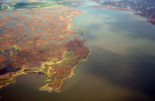
A collection of images for use in science communication with a focus on Chesapeake Bay and its watershed


Home :: Register :: FAQ :: Login
Browse All :: Album list :: Last uploads :: Last comments :: Most viewed :: Most downloaded :: Top rated :: Lightbox :: Advanced Search

Install the IAN Image and Video Library Browser Sidebar for easier navigation and searching.
Image & Video Library Guide - Contains a list of instructions on navigating, uploading and downloading files.
Home > Aerial and Satellite > Aerial and Satellite / Chesapeake Bay
Laws Thorofare
Looking northwest up Laws Thorofare. Deal Island Marsh and Straight Gut are situated on the western side, and Laws Gut can be seen in the northern background.

Laws Thorofare Looking northwest up Laws Thorofare. Deal Island Marsh and Straight Gut are situated on the western side, and Laws Gut can be seen in the northern background. aerial creek gut wetlands protected area marsh bay Deal Island Wildlife Management Area Deal Island Marsh Straight Gut Laws Gut Laws Thorofare Somerset County, Maryland

High Resolution Image (6022 KB) only available for download by registered users (FREE!) - Login or Register Now (Free, Quick & Easy!)

 
Laws Thorofare
Looking northwest up Laws Thorofare. Deal Island Marsh and Straight Gut are situated on the western side, and Laws Gut can be seen in the northern background.
Cod Harbor Looking west at Cod Harbor, on the southern end of Tangier Island. Tangier Sound is in the foreground. aerial Accomack County, Virginia Chesapeake Bay Cod Harbor Tangier Island Tangier Sound bay harbor spit wetlands geomorphology island inlet protected area Cod Harbor Looking west at Cod Harbor, on the southern end of Tangier Island. Tangier Sound is in the foreground. aerial Accomack County, Virginia Chesapeake Bay Cod Harbor Tangier Island Tangier Sound bay harbor spit wetlands geomorphology island inlet protected area Laws Thorofare Looking northwest up Laws Thorofare. Deal Island Marsh and Straight Gut are situated on the western side, and Laws Gut can be seen in the northern background. aerial creek gut wetlands protected area marsh bay Deal Island Wildlife Management Area Deal Island Marsh Straight Gut Laws Gut Laws Thorofare Somerset County, Maryland Laws Thorofare and Tangier Sound Looking northwest up Laws Thorofare. Deal Island Marsh and Straight Gut are situated on the western side. Tangier Sound is in the northern background. aerial Tangier Sound Straight Gut Somerset County, Maryland Laws Thorofare Laws Gut Deal Island Wildlife Management Area Deal Island Marsh wetlands protected area bay creek gut marsh Deal Island and Deal Island Marsh The town of Deal Island lies northwest of Deal Island Marsh.  aerial bay creek marsh homes rural development town wetlands trees protected area residential development Deal Island Marsh Deal Island Wildlife Management Area Lower Thorofare Somerset County, Maryland Tangier Sound
Rate this file (No vote yet)
Rubbish
Poor
Fair
Good
Excellent
Great
File information
Filename:iil_ian_bf_0687.JPG
Album name:bfertig / Aerial and Satellite / Chesapeake Bay
Keywords:aerial creek gut wetlands protected area marsh bay Deal Island Wildlife Management Area Deal Island Marsh Straight Gut Laws Gut Laws Thorofare Somerset County, Maryland
Photographer's Name:Ben Fertig
Photographer's Company:IAN, UMCES
Date Photo was taken (MM/DD/YYYY):05/01/2008
Media Type (Photo, Satellite Image, Vector Graphic, Map, Animation, Video):Photo
File Size:6022 KB
Date added:May 07, 2008
Dimensions:3264 x 2136 pixels
Displayed:4 times
Downloaded:1 times
Image Description:Looking northwest up Laws Thorofare. Deal Island Marsh and Straight Gut are situated on the western side, and Laws Gut can be seen in the northern background.
Color Space:sRGB
Components Configuration:YCbCr
Compressed Bits Per Pixel:5
Customer Render:0
Date Time:2008:05:01 15:00:42
DateTime Original:2008:04:30 20:50:17
DateTime digitized:2008:04:30 20:50:17
Digital Zoom Ratio:1
Exif Image Height:2136 pixels
Exif Image Width:3264 pixels
Exif Interoperability Offset:990
Exif Offset:532
Exif Version:version 2.2
Exposure Bias:0 EV
Exposure Mode:0
Exposure Time:1/500 sec
FNumber:f 3.2
File Source:Digital Still Camera
Flash:Unknown: 80
Flash Pix Version:version 1
Focal length:7.272 mm
Make:Canon
Max Aperture:f 3.2
Metering Mode:Multi-Segment
Model:Canon PowerShot S80
Orientation:Normal (O deg)
Resolution Unit:Inch
Scene Capture Mode:2
Software:Adobe Photoshop CS2 Windows
White Balance:0
X Resolution:180
Y Resolution:180
YCbCrPositioning:Center of Pixel Array
IPTC Title:Laws Thorofare
IPTC Copyright:Copyright to the photographer. Free for any use if appropriate credit is reproduced with the image.
IPTC Keywords:aerial creek gut wetlands protected area marsh bay Deal Island Wildlife Management Area Deal Island Marsh Straight Gut Laws Gut Laws Thorofare Somerset County, Maryland
IPTC Category:
URL:http://ian.umces.edu/imagelibrary/displayimage-2363.html
Lightbox:Add to Lightbox