

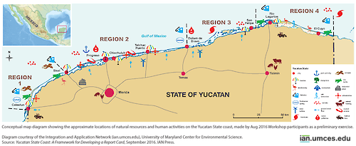
The natural resources and human activities of the Yucatan State Coast
At an Aug 2016 report card workshop in Sisal Mexico, scientists and representatives from the local government and private sector assembled to begin the process of developing an ecosystem health assessment of the Yucatan State coastline. This map diagram shows the approximate locations of the natural resources and human activities in this region.
diagram sea turtle octopus flamingo mangrove fishing development tourism erosion flooding karst septic trash groundwater well animal farm factory sisal water quality pollution overfishing salt extraction red tide habitat loss hurri| Author(s) | Jane Hawkey |
| Author Company | Integration and Application Network |
| Date Created | 2016-08-31 |
| Album | Ecosystems > Coastal/Marine |
| Type | Graphic |
| Publication | Yucatan State Coast |
| Dimensions | 1000 x 410 |
| Filesize | 131.6 kB |
| Number of Downloads | 248 |
| Filetype(s) | PNG |
| License | Attribution-ShareAlike 4.0 International (CC BY-SA 4.0) |
| Required Attribution | Jane Hawkey, Integration and Application Network (ian.umces.edu/media-library) |