Brisbane 2011: Living with Floods and Dancing with Dugongs: Part 11- Monitoring of the Moreton Bay
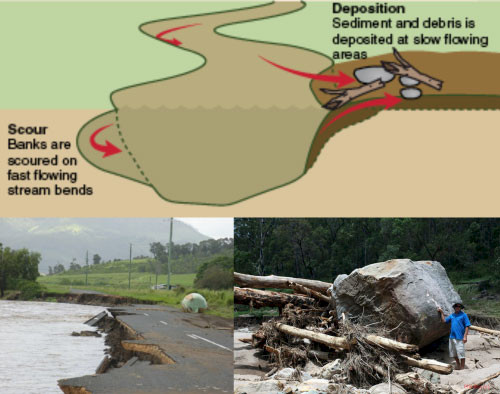
Bill Dennison ·So let's look at Moreton Bay. The Brisbane River catchment soils were heavily eroded, and several folks from Healthy Country helped us assemble this story. We saw large-scale sediment erosion, and we can see boulders that rolled down the stream like pebbles. In some places the granitic bedrock was eroded thirty centimeters, taking the soil out of the paddocks, into the rivers and down, ultimately into Moreton Bay.

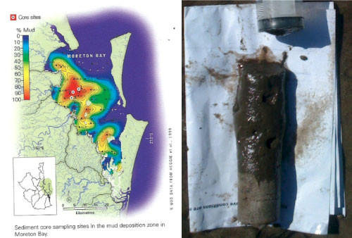
In what we call the mud patch in the Bay, you see a big area of deposition. This is not just full of mud, but it's also nitrogen, phosphorus, and organic material. This is the dirt and fertilizer that comes off catchment and out into Moreton Bay. Al Grinham from the University of Queensland (UQ) has gone out and sampled, and you can easily see the black, oozy stuff over the lighter sand in this extruded syringe of sediment. This black, oozy stuff is very fine sediment, based on his sediment size analysis. This really fine sediment gets suspended with virtually every tide, and every wind event, making this part of the bay very cloudy and turbid, reducing the light that makes it down to the bottom.

Why do we care about the light getting down to the bottom? Because we care about seagrasses. Seagrasses are the coastal canary for light attenuation and that's because seagrasses need more light than any other group of plants on the planet. They need more light by an order of magnitude. Algae can grow with down to 1% light. Seagrasses need 10-30% instantaneous light. And they need that light to be able to stick their roots into the anaerobic soil (the oxygen depleted soil). They have to pump oxygen down, so they not only have to do photosynthesis to supply their leaves, but they have to supply their roots, and the microzones around the roots. What do miners do when a canary dies? They get out of the mines; they don't stop and talk about it; they don't study it. They get out swiftly and decisively, and then they go back and figure out what was wrong. Seagrasses are what gives us that clue and we need to act swiftly and decisively.
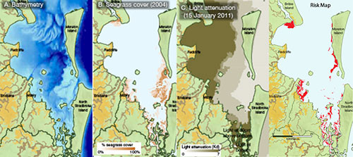
Working with Stewart Phinn, Chris Roelfsema and Mitch Lyons from the University of Queensland, we put together a seagrass risk map. We used the bathymetry of Moreton Bay, and you can see large shallow banks in the Eastern Bay. You can see the deeper area here where all the mud accumulated. We see the seagrass cover map, and we can see that those shallow banks on the Amity and Moreton banks are heavily populated by seagrass as well as up in Deception Bay and Waterloo Bay. Historically, there used to be seagrass in Deception Bay and Bramble Bay but it has been gone for some decades now. Also, we have our light attenuation map using remote sensing imagery. So, we put those three things together, knowing what we know about the seagrass light requirements, so we can produce a map of risk.

And the seagrass risk map shows: Deception Bay- we better be worried; Waterloo Bay- we better be worried; Eastern Banks- not so bad because of the flushing where all the water goes to the north, so that's probably in pretty good shape. In fact I went out and looked at it myself a couple of times. I then went back to the journals and in 1893, Thomas Welsby reports that this guy named Fred Johnson had gone out and observed a huge pod of dugongs in July of 1993 after the February floods. Similarly in '74, George Heinsohn had gone out and monitored the dugongs with aerial photography. So, they were, in fact, in pretty good shape after the '74 flood and the ‘93 flood, and so far so good using the aerial surveys and satellite tagging that is going on [in the year 2011]. So I am cautiously optimistic. The danger we're going to have is immigration from Hervey Bay and from other places where the seagrasses aren't so lucky. So we still might see lots of carcasses, probably not our local dugong, but rather the immigrant dugongs.
This blog post was created from a presentation by Bill Dennison, delivered at the historic Customs House in Brisbane, Australia on 8 July, 2011 (full powerpoint presentation can be accessed on IAN Press.
About the author
Bill Dennison

Dr. Bill Dennison is a Professor of Marine Science and Interim President at the University of Maryland Center for Environmental Science (UMCES).
Next Post > Brisbane 2011: Living with Floods and Dancing with Dugongs: Part 10- Progress in Monitoring and Management
Comments
-
Atika 8 months ago
Thank you for sharing this information with us, i really appreciate your post!