

Lower Mississippi River: Environmental Literacy
Bill Dennison ·'Environmental literacy' series
The seven environmental literacy principles for the Lower Mississippi River are the following:
- The Lower Mississippi River is undammed from St. Louis to its mouth in the Gulf of Mexico.
- The considerable commerce through the Lower Mississippi River includes oceanic transport up to Baton Rouge and barge transport throughout the remainder.
- Flooding and drought affect the river and adjacent floodplain.
- Bottomland hardwoods and wetlands are key habitats in the batture, the floodplain between the large river levees.
- The diverse human cultures along the Lower Mississippi River support industrial development, agricultural land use, and several cultural hubs.
- The current and historical Mississippi River delta has formed an ecologically productive series of wetland and nearshore habitats, which are susceptible to climate change (e.g., sea level rise) and ecological impacts (e.g., Gulf of Mexico hypoxia).
- In spite of various threats including incutting erosion in the tributary riparian soils, toxicants in the food web, salinization, degraded water quality and climate change, there is a paucity of monitoring data for the Lower Mississippi River.
1. The Lower Mississippi River is undammed from St. Louis to its mouth in the Gulf of Mexico.
The Upper Mississippi from St. Louis to Minneapolis/St. Paul, the entire Illinois River, and the Ohio River from the confluence with the Mississippi River to Pittsburgh, are managed as a series of dams and locks to maintain navigation. Most of the Tennessee and Missouri Rivers are managed as a series of dams for irrigation, flood protection and hydroelectric power. In contrast, the Lower Mississippi River is undammed and navigation channels in this portion of the Mississippi River are largely maintained by a series of dikes which restrict flow into the main channel, inducing scour by the water currents.

2. The considerable commerce through the Lower Mississippi River includes oceanic transport up to Baton Rouge and barge transport throughout the remainder.
The Lower Mississippi River has historically and is currently a major transportation thoroughfare. The early exploration and colonization of the United States was facilitated by river transport. Oceanic transport of containers and automobiles is limited to the coastal section of the the Mississippi River, that extends from the Gulf of Mexico to Baton Rouge, with a controlling depth of 45 feet. A fixed bridge spanning the river at Baton Rouge has served as an impediment to oceanic vessels. North of Baton Rouge, the controlling depth is 9 feet and the traffic is largely tugboats and barges laden with coal, grains and sand and gravel. The energy costs and associated carbon footprint for barge transport vs. rail or truck transport is considerably lower.

3. Flooding and drought affect the river and adjacent floodplain.
Since the Lower Mississippi River is downstream from such a massive watershed, and there are no mainstem river dams in this section, there is a very real potential for flooding. In 1927, a major flood occurred accounting for a large loss of property and life. The last significant flood was 2011, but flood management levees and diversions onto adjacent lands and into distributaries were able to avert major damages and loss of life. Severe droughts also have affected this section of the river, with dredging and shallow draft barges required to maintain shipping. Droughts also affect the secondary channels.

4. Bottomland hardwoods and wetlands are key habitats in the batture, the floodplain between the large river levees.
The batture is the land within the 100 year levees that is only submerged at high flows. This land which is periodically flooded supports bottomland hardwood forests (oaks, gums and bald cypress) which provide important wildlife habitat. Wetlands also are important habitat in the batture, and along with bottomland hardwood forests, open water and unvegetated habitats, support the migratory birds that use the Mississippi flyway. The Mississippi River Valley alluvial sediments dominate the floodplain and these sediments have high phosphorus contents. These fine grained sediments are susceptible to erosion.

5. The diverse human cultures along the Lower Mississippi River support industrial development, agricultural land use, and several cultural hubs.
The land along the Lower Mississippi River has been settled by a diversity of converging cultures. The complex history of various settlers, with various waves of immigration, has led to a rich diversity of architecture, music, literature and the arts. Three major musical genres have their hubs in the Lower Mississippi River; New Orleans (jazz), Memphis (blues) and Nashville (country). The riverside industrial development relies on the river for navigation and in some cases water supply. There are considerable coastal, nearshore and offshore gas and oil resources exploited in the Lower Mississippi River delta. The low lying floodplain contains rich agricultural soil which supports multiple crops (e.g. rice, cotton, corn, soybean).

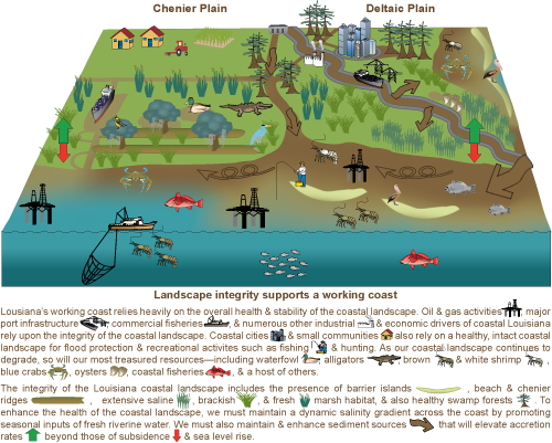
6. The current and historical Mississippi River delta has formed an ecologically productive series of wetland and nearshore habitats, which are susceptible to climate change (e.g., sea level rise) and ecological impacts (e.g., Gulf of Mexico hypoxia).
The delta of the Mississippi River has migrated considerably over the past millennia, forming an extensive network of wetlands, bayous, and nearshore habitats. The westward longshore drift of deltaic sediments has formed the chenier plain of western Louisiana. These deltaic and chenier habitats support robust fisheries and wildlife resources. High rates of relative sea level rise lead to wetland loss and vulnerability of coastal communities to storm surge. An annual hypoxia zone in the Gulf of Mexico develops as a result of excess nutrients and nearshore algal blooms.
7. In spite of various threats including incutting erosion in the tributary riparian soils, toxicants in the food web, salinization, degraded water quality and climate change, there is a paucity of monitoring data for the Lower Mississippi River.
There are well documented threats to the Lower Mississippi basin, yet there is a paucity of monitoring data of the mainstem river in this region. This is partially due to the Mississippi River forming state boundaries and federal jurisdictional boundaries for much of the Lower Mississippi River (except Louisiana). In addition, it is a large, busy and often fast moving river, complicating logistics. The incutting erosion of the Mississippi tributaries is a result of the channelization, dikes and levees to maintain navigation. Toxicants in the food web have been documented, ongoing salinization upriver and degraded water quality (e.g., excess nutrients) has been observed, supporting the need for an integrated monitoring strategy.
. Source: SERC")
About the author
Bill Dennison

Dr. Bill Dennison is a Professor of Marine Science and Interim President at the University of Maryland Center for Environmental Science (UMCES).