

Summer water quality and aquatic grass wrap-up
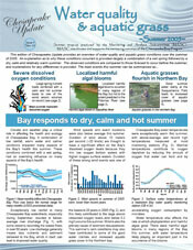 The EcoCheck Project (NOAA-UMCES partnership) in collaboration with the Chesapeake Bay Program (CBP) and some of its partners has released the latest edition of the Chesapeake Update newsletter. This edition provides an overview of water quality and aquatic grass conditions over the summer of 2005. An explanation as to why these conditions occurred is provided – largely a combination of a wet spring followed by a dry, calm, and relatively warm summer. The observed conditions are compared to those forecast to occur before the summer, and explanations for any differences are provided. The main events this summer can be summarized as severe dissolved oxygen conditions, localized harmful algal blooms, and aquatic grasses flourish in the Northern Bay.
Workshop at Louisiana State University to synthesize issues of protection and restoration of coastal Louisiana.
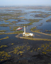 The discussions are building on the wealth of previous studies in the region and the aim is to help facilitate production of science communication products. This project was intended to start with a workshop at Horn Point – which was cancelled due to Hurricane Katrina, rescheduled to take place in Louisiana, and again cancelled due to Hurricane Rita. So finally, Bill Dennison and Tim Carruthers traveled to Baton Rouge for two days of workshops with scientists and resource managers, followed by a day of meetings working on a science newsletter to be entitled ‘Reducing Flood Damage in Coastal Louisiana: Communities, Cultures, and Commerce’. Jane Thomas assisted online from Horn Point by creating graphics and draft newsletter formats. Alaina Owens from LSU is subsequently visiting IAN staff for a week to work on the newsletter, which will be the first in a series for issues in coastal Louisiana. Visit the Coastal Louisiana Ecosystem Assessment and Restoration (CLEAR) website for further information.
Conceptual diagrams used in publication on nutrient dynamics of seagrass meadows.
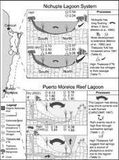 A recent article in Estuarine Coastal and Shelf Science (64: 191-199) by Tim Carruthers, Brigit van Tussenbroek, and Bill Dennison uses conceptual diagrams to synthesize the results of a project carried out in the eastern Yucatan peninsula. The study assessed the tissue nutrients and δ15N of Thalassia testudinum growing in the Nichupte Lagoon adjacent to Cancun, and then adjacent to and distant from submarine vent sites within the Puerto Morelos Lagoon. Greater seagrass tissue nitrogen and a high δ15N ratio indicated that sewage nitrogen was high close to Cancun, whereas seagrass near to submarine vents in the Puerto Morelos Reef Lagoon indicated a greater availability of phosphorus to the seagrass. This paper is an example of how conceptual diagrams created with the IAN symbol libraries can be used to provide graphical representations of system processes in the published literature.
New IAN Personnel
 In November 2005, UMCES hired Sewelo Sewelo Keleagetse to be a GIS Analyst, a position located at the Chesapeake Bay Program office in Annapolis, MD. In this position he will provide geographic information systems and web mapping application capabilities to the GIS Team. Originally from Botswana in southern Africa, Sewelo comes to us from York, Pennsylvania where he served as a GIS Analyst II with a private engineering and architectural firm, Buchart-Horn, Inc. and Basco Associates. Sewelo’s degrees include a BSC in Wildlife and Fisheries Management from West Virginia University, and an MA in Geography from West Virginia University. Sewelo’s interests outside of work include horse/donkey riding, playing soccer and basketball, miscellaneous reading, and watching sports on television. Please join us in welcoming Sewelo to UMCES.