

Communicating Science Effectively course
The next course in 'Communicating Science Effectively and Integrated Ecosystem Assessment' is to be held at the University of Maryland Center for Environmental Science in Cambridge, Maryland from the 3rd to 7th April, 2006.Register online now!Integration and Application Network Summer Student
This summer student position is aimed at the students majoring in the sciences and who will be going into at least their junior year of college. See the UMCES employment page for further details.IAN awarded Packard Foundation grant to develop science communication tools
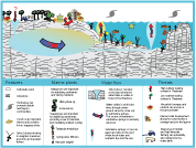 The Integration and Application Network team recently received Packard Foundation funding for a two-year project to develop science communication tools for three sites within the Packard Foundation's Regional Initiative: Morro Bay (California), the Gulf of California (Mexico), and Palau. These workshops will be used as case studies to develop a handbook for integrated assessment and the project will further expand the conceptual diagram symbol libraries and produce web-based tutorials on using science communication tools. Ultimately, this project aims to use these three geographically and ecologically distinct Packard Foundations Regional Initiative sites to demonstrate the process of integrated assessment as well as develop a library of tools and resources for other locations to perform their own integrated assessments.
Global seagrass trajectories project launched
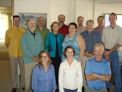 A working group of a dozen scientists from Australia, Europe and the U.S. was established in February 2006 at the National Center for Ecological Analysis and Synthesis (NCEAS) in Santa Barbara, California. Drs. Bill Dennison and Tim Carruthers helped initiate a two-year project in which a global assessment of seagrass gains and losses will be used to develop ecological forecasts. The project, “Global trajectories of seagrasses: Establishing a quantitative basis for seagrass conservation and restoration”, is constructing a global database of seagrass distributional changes, testing the perception that a contemporary crisis in seagrass ecosystems is occurring due to coastal human population pressures.
International Tidal Wetlands Conference
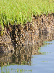 A Mid-Chesapeake Bay Marshlands Restoration project is being developed by the Integration and Application Network in conjunction with the Army Corps of Engineers, Maryland Port Administration, US Fish & Wildlife Service and Maryland Department of Natural Resources. An International Tidal Wetlands Conference will be held May 31-June 2 at Salisbury University to discuss the ecological, economic and engineering issues associated with using dredge materials to restore the eroding marshes of mid-Chesapeake Bay. Drs. Jeff Cornwell, Dennis King, Court Stevenson and IAN staff are on the conference planning committee and will conduct a targeted scoping workshop on March 10 to develop background materials.
Remote sensing symposium
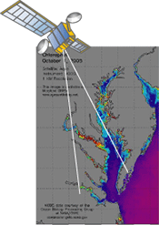 On January 31st, 2006, the Integration and Application Network, in collaboration with NOAA, EcoCheck, and Maryland DNR, convened a symposium on remote sensing water quality in Chesapeake Bay. The aim of the symposium was to facilitate the integration of remote sensing products into Chesapeake Bay decision support tools by identifying priority tasks and the required synergies and linkages between projects to address these tasks. There was excellent turnout to the symposium with an effective balance of remote sensing experts, data analysts, and end users. Inclusion of MODIS products was identified as one of the immediate priorities, and a number of projects required to integrate MODIS over the next two years were identified, with one project already making some immediate progress. Presentations and further information can be found at the NOAA Chesapeake Bay website.