

New COSEE Center: Coastal Trends
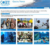 A new Center for Ocean Science Education Excellence (COSEE) has been established through the collaborative effort of several institutions, including the UMCES Horn Point Laboratory (HPL) and the Integration and Application Network (IAN). IAN's role includes development of communication tools, including the website, which has information on programs and activities, workshops, and an eNewsletter. Media-rich educational materials and classroom unit plans will be available in the coming months. Coastal Trends focuses on long and short term trends in our dynamic coastal systems through workshops for teachers and programs and activities for the general public.
IAN staff lead a workshop to develop a report card for Central Kura Basin, South Caucasus
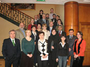 The Kura river runs through the Republic of Georgia, Armenia and Azerbaijan, eventually reaching the Caspian Sea. The South Caucasus Water Program, funded by USAID, has spent three years building collaborations between water quality monitoring efforts in the three countries. IAN staff spent a week working with the program and partners to produce a demonstration report card for the central Kura basin and also provide science communication training to participants from all three countries.
Watershed condition assessment for Rock Creek Park
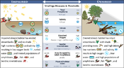 As part of the ongoing collaboration between IAN and Inventory and Monitoring at the National Capital Region Network of the National Parks Service, IAN staff presented the Watershed Condition Assessment for Rock Creek National Park. This presentation was one of four demonstration projects at the Water Resource Division aquatic professionals meeting in Fort Collins, Colorado, as part of continuing efforts to develop recommendations for carrying out these assessments across the US.
Managing the cultural and natural resources of the national parks of west Hawai'i island
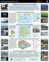 The historical link between native Hawaiian culture and the natural environment means that all natural resources (native species, water features, and landscapes) also have cultural significance. One example is the Ala Kahakai National Historic Trail, a 175-mile corridor that circumnavigates 3/4 of the island and encompasses many of the natural resources on the island of Hawai'i. Like other parks of west Hawai'i, it is a park that must manage both a cultural and natural heritage. IAN staff, in collaboration with the Pacific Island Network of the National Park Service Inventory & Monitoring program, created posters for each of the four parks of west Hawai'i, representing the resource features and current challenges facing their individual parks. The posters will be displayed in the parks to communicate this information to the public.