

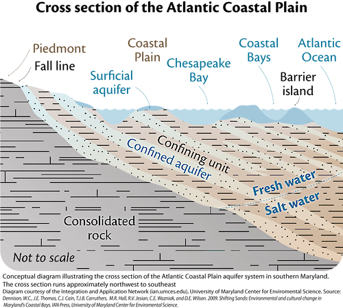
Cross section of the Atlantic Coastal Plain
Conceptual diagram illustrating the conceptual cross section of the Atlantic Coastal Plain aquifer system in southern Maryland. The cross section runs approximately northwest to southeast.
diagram fresh water salt water fall line piedmont chesapeake bay barrier island aquifer atlantic| Property | Value |
|---|---|
| Author(s) | Jane Thomas |
| Author Company | Integration and Application Network |
| Date Created | 2009-01-01 |
| Album | Ecosystems > Coastal/Marine |
| Type | Graphic |
| Publication | Shifting Sands: Environmental and cultural change in Maryland's Coastal Bays |
| Project(s) | Maryland Coastal Bays Science Communication Products and Report Cards |
| Dimensions | 1000 x 900 |
| Filesize | 254.7 kB |
| Number of Downloads | 339 |
| Filetype(s) | PNG |
| License | Attribution-ShareAlike 4.0 International (CC BY-SA 4.0) |
| Required Attribution | Jane Thomas, Integration and Application Network (ian.umces.edu/media-library) |