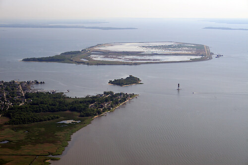
A collection of images for use in science communication with a focus on Chesapeake Bay and its watershed


Home :: Register :: FAQ :: Login
Browse All :: Album list :: Last uploads :: Last comments :: Most viewed :: Most downloaded :: Top rated :: Lightbox :: Advanced Search

Install the IAN Image and Video Library Browser Sidebar for easier navigation and searching.
Image & Video Library Guide - Contains a list of instructions on navigating, uploading and downloading files.
Home > Aerial and Satellite > Aerial and Satellite / Chesapeake Bay
Hart-Miller Island
Hart-Miller Island at the mouth of the Back River. The restoration of Hart-Miller Island using dredged material is a joint project by Department of Natural Resources (DNR), the Maryland Port Administration, the U.S. Army Corps of Engineers, Maryland Environmental Service, and the Maryland Department of the Environment

Hart-Miller Island Hart-Miller Island at the mouth of the Back River. The restoration of Hart-Miller Island using dredged material is a joint project by Department of Natural Resources (DNR), the Maryland Port Administration, the U.S. Army Corps of Engineers, Maryland Environmental Service, and the Maryland Department of the Environment Chesapeake Bay river marshes

High Resolution Image (4176 KB) only available for download by registered users (FREE!) - Login or Register Now (Free, Quick & Easy!)

 
Hart-Miller Island
Hart-Miller Island at the mouth of the Back River. The restoration of Hart-Miller Island using dredged material is a joint project by Department of Natural Resources (DNR), the Maryland Port Administration, the U.S. Army Corps of Engineers, Maryland Environmental Service, and the Maryland Department of the Environment
Back River Back River, Baltimore Chesapeake Bay river development city Back River Back River, Baltimore Chesapeake Bay river development city Hart-Miller Island Hart-Miller Island at the mouth of the Back River. The restoration of Hart-Miller Island using dredged material is a joint project by Department of Natural Resources (DNR), the Maryland Port Administration, the U.S. Army Corps of Engineers, Maryland Environmental Service, and the Maryland Department of the Environment Chesapeake Bay river marshes Magothy River Mouth of the Magothy River, looking across Chesapeake Bay to Kent Island. The Bay Bridge is visible in the background, far right. Chesapeake Bay river shoreline trees Deep Creek Deep Creek and Cape St Claire on the Magothy River. Chesapeake Bay, Kent Island, and the Bay Bridge are visible in the background. Chesapeake Bay river trees shoreline
Rate this file (current rating : 0 / 5 with 1 votes)
Rubbish
Poor
Fair
Good
Excellent
Great
File information
Filename:iil_ian_jt_0617.jpg
Album name:JaneT / Aerial and Satellite / Chesapeake Bay
Rating (1 votes):
Keywords:Chesapeake Bay river marshes
Photographer's Name:Jane Thomas
Photographer's Company:IAN, UMCES
Date Photo was taken (MM/DD/YYYY):05/24/2007
Media Type (Photo, Satellite Image, Vector Graphic, Map, Animation, Video):Photo
File Size:4176 KB
Date added:May 30, 2007
Dimensions:3504 x 2336 pixels
Displayed:43 times
Downloaded:0 times
Image Description:Hart-Miller Island at the mouth of the Back River. The restoration of Hart-Miller Island using dredged material is a joint project by Department of Natural Resources (DNR), the Maryland Port Administration, the U.S. Army Corps of Engineers, Maryland Environmental Service, and the Maryland Department of the Environment
Color Space:sRGB
Components Configuration:YCbCr
Customer Render:0
Date Time:2007:05:30 12:44:03
DateTime Original:2007:05:24 08:08:49
DateTime digitized:2007:05:24 08:08:49
Exif Image Height:2336 pixels
Exif Image Width:3504 pixels
Exif Interoperability Offset:1092
Exif Offset:686
Exif Version:version 2.21
Exposure Bias:0 EV
Exposure Mode:0
Exposure Program:Landscape
Exposure Time:1/250 sec
FNumber:f 11
Flash:No Flash
Flash Pix Version:version 1
Focal length:55 mm
ISO:100
Make:Canon
Metering Mode:Multi-Segment
Model:Canon EOS 30D
Orientation:Normal (O deg)
Resolution Unit:Inch
Scene Capture Mode:0
Software:Adobe Photoshop CS2 Windows
White Balance:0
X Resolution:72
Y Resolution:72
YCbCrPositioning:Datum Point
IPTC Title:Hart-Miller Island
IPTC Copyright:Copyright to the photographer. Free for any use if appropriate credit is reproduced with the image.
IPTC Keywords:Chesapeake Bay river marshes
IPTC Category:
URL:http://ian.umces.edu/imagelibrary/displayimage-1551.html
Lightbox:Add to Lightbox