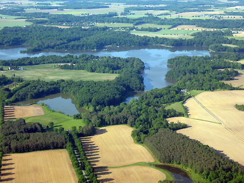
A collection of images for use in science communication with a focus on Chesapeake Bay and its watershed


Home :: Register :: FAQ :: Login
Browse All :: Album list :: Last uploads :: Last comments :: Most viewed :: Most downloaded :: Top rated :: Lightbox :: Advanced Search

Install the IAN Image and Video Library Browser Sidebar for easier navigation and searching.
Image & Video Library Guide - Contains a list of instructions on navigating, uploading and downloading files.
Home > Aerial and Satellite > Aerial and Satellite / Chesapeake Bay
Riparian Buffer
Small tributary to the Chesapeake Bay showing forest riparian buffer which reduces sediment and nutrient run-off from adjacent farming.

Riparian Buffer Small tributary to the Chesapeake Bay  showing forest riparian buffer which reduces sediment and nutrient run-off from adjacent farming. tributary riparian buffer farming

High Resolution Image (5702 KB) only available for download by registered users (FREE!) - Login or Register Now (Free, Quick & Easy!)

 
Riparian Buffer
Small tributary to the Chesapeake Bay showing forest riparian buffer which reduces sediment and nutrient run-off from adjacent farming.
Developed Shoreline and Jetties Shoreline development along the Eastern Shore of Chesapeake Bay, showing a large number of jetties. development shoreline jetties Chesapeake Bay Development on Eastern Shore Housing development surrounded by forest along the Eastern Shore of the Chesapeake Bay. Riparian Buffer Small tributary to the Chesapeake Bay  showing forest riparian buffer which reduces sediment and nutrient run-off from adjacent farming. tributary riparian buffer farming Patchwork of fields Patchwork of fields along the Eastern Shore of the Chesapeake Bay. patchwork agriculture Western Shoreline of Chesapeake Bay Western shoreline of Chesapeake Bay, showing urban development in foreground and forest in the background.
Rate this file (No vote yet)
Rubbish
Poor
Fair
Good
Excellent
Great
File information
Filename:iil-eco-en-00049.jpg
Album name:Emily.Nauman / Aerial and Satellite / Chesapeake Bay
Keywords:tributary riparian buffer farming
Photographer's Name:Ben Longstaff
Photographer's Company:IAN, UMCES
Date Photo was taken (MM/DD/YYYY):05/24/2007
Media Type (Photo, Satellite Image, Vector Graphic, Map, Animation, Video):Photo
File Size:5702 KB
Date added:May 15, 2008
Dimensions:3264 x 2448 pixels
Displayed:3 times
Downloaded:1 times
Image Description:Small tributary to the Chesapeake Bay showing forest riparian buffer which reduces sediment and nutrient run-off from adjacent farming.
Color Space:sRGB
Components Configuration:YCbCr
Compressed Bits Per Pixel:3
Customer Render:0
Date Time:2008:05:15 09:38:07
DateTime Original:2007:05:23 20:05:39
DateTime digitized:2007:05:23 20:05:39
Digital Zoom Ratio:1
Exif Image Height:2448 pixels
Exif Image Width:3264 pixels
Exif Interoperability Offset:1272
Exif Offset:512
Exif Version:version 2.2
Exposure Bias:0 EV
Exposure Mode:0
Exposure Time:1/200 sec
FNumber:f 4.5
File Source:Digital Still Camera
Flash:Unknown: 88
Flash Pix Version:version 1
Focal length:15.144 mm
Make:Canon
Max Aperture:f 4.5
Metering Mode:Multi-Segment
Model:Canon PowerShot S80
Orientation:Normal (O deg)
Resolution Unit:Inch
Scene Capture Mode:0
Software:Adobe Photoshop CS2 Windows
White Balance:0
X Resolution:180
Y Resolution:180
YCbCrPositioning:Center of Pixel Array
IPTC Title:Riparian Buffer
IPTC Copyright:Copyright to the photographer. Free for any use if appropriate credit is reproduced with the image.
IPTC Keywords:tributary riparian buffer farming
IPTC Category:
URL:http://ian.umces.edu/imagelibrary/displayimage-2469.html
Lightbox:Add to Lightbox