IAN is committed to producing practical, user-centered communications that foster a better understanding of science and enable readers to pursue new opportunities in research, education, and environmental problem-solving. Our publications synthesize scientific findings using effective science communication techniques.
A Report to the Maryland General Assembly, Governor, and Secretary of Natural Resources in Response to Senate Bill 830 (2022)
North, E., M. W. Gray, M. Fabra, J. Shaner, C. Keitzer, and R. Nair-Gonzalez ·
This report is in response to Senate Bill 830 (2022) that instructed the University of Maryland Center … for Environmental Science (UMCES) to evaluate the following topics in collaboration with Smithsonian … Environmental Research Center, Virginia Institute of Marine Science, appropriate State and federal … agencies, and industry and other stakeholders:
Maloney KO, Fanelli RM, Cashman MJ, Boyle LJ, Gordon SE, Gressler BP, Katoski MP, Kiser AH, Metes MJ, Noe GB, Sekellick AJ, Sussman A, and Young JA ·
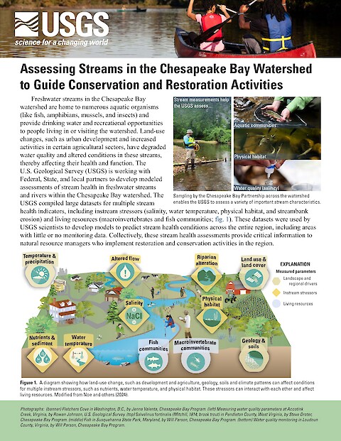
Freshwater streams in the Chesapeake Bay watershed are home to numerous aquatic organisms (like fish, amphibians, mussels, and insects) and provide drinking water and recreational opportunities to people living in or visiting the watershed. Land-use changes, such as urban development and increased activities in certain agricultural sectors, have degraded water quality and altered conditions in these streams, thereby affecting their health and function.
Matthew Gray, Elizabeth North, William Nardin, Monica Fabra, Kurt Florez, Conor Keitzer, Roshni Nair-Gonzalez, and David Nemazie ·
Structures (SHORES) is part of an effort to fill key knowledge gaps in support of Maryland’s … oyster resource and oyster industries. Chesapeake Bay is home to thriving commercial fishing and … aquaculture industries and one of the largest oyster restoration efforts in North America. The lack of … fresh shell substrate has become a major impediment to all of these activities and alternatives are … being considered for large-scale use in restoration and industry efforts.
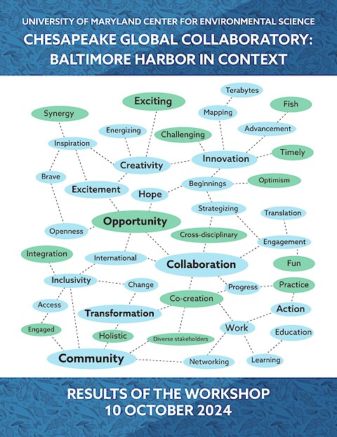
The recent tragic collapse of the Francis Scott Key Bridge has highlighted the critical importance of Baltimore Harbor to the region’s infrastructure, environment, and economy. In response, the University of Maryland Center for Environmental Science (UMCES), through its Chesapeake Global Collaboratory (CGC), hosted “Baltimore Harbor in Context” on October 10, 2024. The event gathered diverse stakeholders and featured plenary talks, panel discussions, and interactive breakout sessions.
Report on the Virtual Symposium held Feb 26-28, 2024
North, Elizabeth W., Monica Fabra, Conor Keitzer, Roshni Nair, and Matthew Gray. ·
This symposium and report were sponsored by the State of Maryland and convened and produced … by University of Maryland Center for Environmental Science (UMCES). Lead organizers were Dr. Elizabeth North and Dr. Matthew Gray of UMCES Horn Point Laboratory. The symposium team also … included David Nemazie, Conor Keitzer, Roshni Nair, Monica Fabra, and Kurt Florez. Graphic design … and logistical support were provided by the UMCES Integration and Application Network (IAN).
Ziolkowski D, Celis-Murillo A, Malpass J, Pardieck K, Martin J, and Walker L ·
Birds are vital to our economy, ecosystems, and cultural heritage. Investing in bird conservation benefits communities, businesses, and working lands while reinforcing our nation’s legacy of stewardship and biodiversity. By valuing birds, we ensure a richer, healthier, and more vibrant future for all Americans.
Vargas-Nguyen V, Kelsey H, Badri L, Adebayo A, Breton T, Byun J, Fife A, Kalama I, Matthew L, Novara A, Sequeira R ·
Coastal environments face unique challenges that profoundly affect human well-being. Stressors such as pollution, rising temperatures, flooding, harmful algal blooms (HABs), and emerging contaminants threaten ecosystems and disproportionately impact vulnerable communities. This report presents the findings from the Fall 2024 Coastal Environment and Community Health course, by graduate students in the Marine, Estuarine, and Environmental Science program at the University System of Maryland.
This 24-page strategic plan highlights IAN's impact so far, along with the mission, vision, and values by which IAN conducts itself. This document details IAN's objectives for the next five years.
This document describes the methods and development process for the Southeast Michigan Report Card, and the five associated watershed report cards: the Clinton River Report Card, Detroit River Report Card, Huron River Report Card, River Raisin Report Card, and Rouge River Report Card.