
Coral Reef Report Card workshop during the XI Mexican Coral Reef Congress and II PanAmerican Coral Reef Congress

A Coral Reef Report Card workshop was held on September 27th in Veracruz, Mexico as part of the activities of the XI Mexican Coral Reef Congress and II PanAmerican Coral Reef Congress. While in 2019 the Harte Research Institute for Gulf Mexico Studies (HRI) and UNAM-Sisal released a preliminary report card, the goal now is to develop a tri-national quantitative coral reef assessment for the whole Gulf of Mexico.
To highlight the work already done in the region, the workshop included short presentations of report cards developed in Mexico, the U.S., and Cuba. In 2021 in Mexico, Sea&Reef and local partners released a report card for the reefs in the state of Veracruz, while LANRESC, HRI and UNAM-Sisal produced the Alacranes Reef National Park report card for the Yucatán area. In the U.S., HRI developed the first Texas Ecosystem Health Report Card in 2019 and is now working on updates; NOAA and IAN published the Coral Reef Ecosystem Status Reports in 2020, including the Flower Garden Banks and Florida Keys reefs in the northern gulf. Cuba’s report card is hot off the press and will soon be available.
This workshop was special in that rarely people from the U.S., Mexico, and Cuba can engage in in-person discussions. Around 30 participants from universities and government agencies brainstormed ideas on common and shared coral reef socio-ecological indicators and funding options.
Overall, this was a great opportunity to continue building and strengthening a community of practitioners within the Gulf of Mexico region.
Land use and cover has management implications
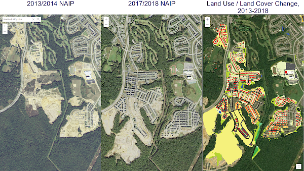
In partnership with the USGS, the IAN team produced a summary of the Chesapeake Bay Program's new Land Use/Land Cover (LULC) Project. The summary includes:
- The need to have a 1-m resolution data set
- The methods for data collection, synthesis, and mapping
- The major findings of the new data set analysis. The characterization of the types of land use show that turf grass is the largest “crop” in the watershed. The land-change analysis reveals that timber harvest produced the largest land change in the watershed
- Some management implications for the Chesapeake Watershed Agreement Goals and outcomes, including those for water quality, land conservation and healthy watershed, and vital habitat
You can view the summary on the USGS website. The LULC data sets are also available online, with 2013/2014 and 2017/2018 comparative maps.
Patuxent River Stakeholder Listening Sessions are underway
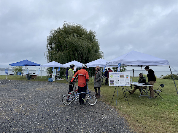
On Wednesday, October 5th, we held a Stakeholder Listening Session for the upcoming Patuxent River Report Card at the Chesapeake Biological Laboratory. Despite the overcast weather, dozens of people turned out to talk with our science communicators about values and threats in the watershed and participate in our interactive stations. A second Stakeholder Listening Session was held at Jug Bay Wetlands Sanctuary on Saturday, October 8th. We are glad to see people give their input on the Patuxent River!
Coming soon: Upper Rio Grande Report Card
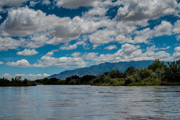
Next month, IAN and its partners will release the first iteration of an ecosystem health report card for the Upper Rio Grande. The report card publication will be the culmination of over two years of hard work, with dedicated teams from WWF, Audubon New Mexico, University of Massachusetts Amherst, and IAN collaborating with stakeholders to gather relevant socio-environmental data relevant to this historic watershed. The report card itself provides a present-day snapshot of Rio Grande from its headwaters in Colorado to just south of El Paso, Texas. It is our hope that this report card is the first of a series of publications that will eventually cover the entire length of the Rio Grande.