We're all connected to the Big Easy: Beyond Science into BIG Management of Coastal Louisiana Ecosystem
Yini Shangguan, Katie Lecorchick, Melissa Day · | Case studies | 1 commentsCoastal Louisiana (CL) is an economically valuable, ecologically diverse landscape, containing 40-45%of the wetlands found in the southern states1. Vital at the national scale, CL is especially important to the seafood and shipping industries, and is home to a significant proportion of the nation’s petroleum industry. Emerging about 6000 years ago after eustatic sea level stabilized2; the coast is now confronted with anthropogenic development, sinking, erosion, hypoxia, susceptibility to hurricanes and sea level rise. In 2005, Hurricanes Katrina and Rita were a wake-up call to a jumble of conflicting policies and regulations. This is not only a susceptible environment but comes with amplified risks to lives, property and economics.
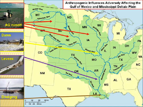
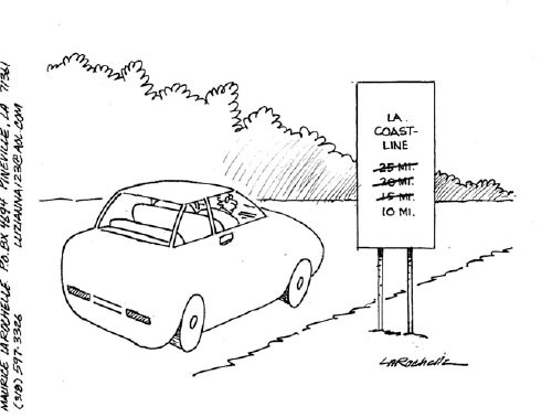
The CL integrated management strategy for protection and restoration is largely challenged due to the numerous ecosystem problems. Much of the wetland deterioration has taken place due to the lack of River sediment. Dams and levees were constructed as flood protection; however, the process prevents overflow and sediment deposition, thus wetlands deteriorate. It is shocking that CL and the Mississippi Deltaic Plain (MDP) are experiencing land loss at a rate as high as 100 km2/year3,4, almost exclusively due to the anthropogenic impact during the 20th century. The primary impact being the isolation of the river from the MDP which reverses the natural land building of the past millennia5,6. Complexity surrounds even the simplest solution of using the natural sediment to build the delta. While the sediment is needed, the excess nutrients contained within the sediment create a different problem.


A hypoxic zone in the Mississippi River/Northern Gulf of Mexico has been documented since 1985 and has averaged an area larger than the state of Connecticut during its peak summer months since 20018. Nitrogen loading in Mississippi-Atchafalaya River Basin is the primary contributor to the increased hypoxia in the Northern Gulf of Mexico9. If the flood plains were open, nutrients could be absorbed by the trees, grasses and swamps, but the levees prevent this. The practical solution is to reduce the nutrients from the source, the Mid-west, where agriculture is king and fertilizer is applied in excess. But how do you reduce non-point nutrient input when you must convince farmers living 1000s of miles away that they are polluting the Gulf of Mexico? It echoes Upton Sinclair’s quote that “it is difficult to get a man to understand something when his job depends on him not understanding it” since the benefit is so intangible.
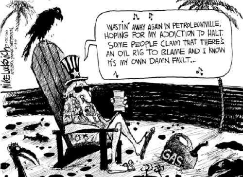
Wetland restoration, flood protection, and the maintenance of navigation are not stand-alone issues but integrated within each other. How will we balance the huge social-economic needs with ecological restoration? People, having an insatiable thirst for energy, want to take advantage of every part of the land but live unsustainably. Compromise must be reached between commercial navigation, oil and natural gas extraction, and river diversions and the natural coastal restoration processes. No solution exists without ‘sacrifices’ from everyone.

Fortunately, the US Army Corps of Engineers and the State of Louisiana have reached the agreement on a single long-term comprehensive plan which includes a small number of high-priority projects for initial implementation. Cooperation and collaboration between Corps and multiple state authorities, while appreciated, is suggestive of a piecemeal approach and may hinder the restoration and protection across the region. Nevertheless, the Corps comprehensive plan implements a variety of restoration measures, and recommendations for scientific monitoring and modeling. We expect scientists’ work to cover not only sound research but also a comprehensive management strategy actively articulated to policymakers and stakeholders.
On a smaller scale, the Chesapeake Bay is also adversely affected by hypoxia from non-point source pollution and uses policy and new comprehensive planning to address it. The EPA’s introduction of Total Maximum Daily Load (TMDL), a recent development in the restoration effort, seeks to improve water quality by limiting the flux of pollutants into the waterway through a strict “pollution diet”11. As our guest speaker Dr. Robert Summers, Secretary of Maryland Department of the Environment, shared that sector of agriculture and wastewater have been making progress and are on track to meet the TMDL goal for 2017. However, pollution from the urban and suburban storm water and septic systems are not. The solution is the Municipal Separate Storm Sewer Systems (MS4) and National Pollutant Discharge Elimination System (NPDES) permit program. In existence for over fifteen years, now it is mandatory but requires a significant investment. Controversy exists because of TMDL usage in the Chesapeake Bay Model. Modeling and monitoring are a major part of the management of the Chesapeake Bay Program, albeit imperfect. One thing is universally true- without proper communication and public support, no management strategy will succeed.

Recommended reading
Managing for Sustainable Ecosystems: Our Human Role
References
- Gosselink, J. G., J. M. Coleman, and R. R. Stewart, Jr. 1998. Coastal Louisiana. pp. 385-436. In M. J. Mac, P. A. Opler, C. E. Puckett Haecker, and P. D. Doran. 1998. Status and Trends of the Nation’s Biological Resources, Vol. 2. Reston: U.S. Department of the Interior, U.S. Geological Survey.
- Saucier, R. 1994. Geomorphology and Quaternary Geologic History of the Lower Mississippi Valley (U.S. Army Corps of Engineers, Vicksburg, MS), Vol. 1.
- Britsch. L, and J. Dunbar. 1993. Land Loss Rates: Louisiana Coastal Plain. Journal of Coastal Research, 9, 324.
- Gagliano, S., K. Meyer-Arendt, and K. Wicker. 1981. Trans Gulf Coast Association of Geological Societies, Trans., 31, 295.
- Day, J. W. Jr. et al. 2000. Estuaries, 23, 425.
- Boesch, D. F. et al. 1994. Journal of Coastal Research, Special Issue 20.
- Cartoon depicts vanishing coast
- Rabalais, N. N., R. E. Turner, and D. Scavia. 2002. BioScience, Vol. 52, No. 2, 129-142.
- Boesch, D. F., W. R. Boynton, and L. B. Crowder, et al. 2009. Eos, Vol. 90, 117-128.
- United States Environmetal Protection Agency. 2010. Chesapeake Bay TMDL Executive Summary.
- Oil Spill may make dead zone deader
Authors
Yini Shangguan, Katie Lecorchick and Melissa Day
Next Post > Biophilia on a coral cay: Reflections from Lady Elliot Island
Comments
-
Yini Shangguan 13 years ago
It might be a good reading too.
http://www.nae.edu/Publications/Bridge/TheAftermathofKatrina/RestoringCoastalLouisianaPlanningwithoutaNationalWaterPolicy.aspx