

An intimate encounter with the rocks of the Potomac River
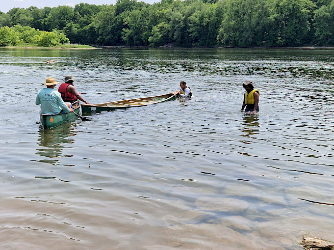
Emma Gee ·For our second field trip of the summer, the GSS cohort traveled to Brunswick, Maryland–just a few towns over from Harper’s Ferry and the point where West Virginia, Virginia, and Maryland meet. Our mission: paddle our canoes to what we soon discovered to be the aptly named Point of Rocks.
As we embarked, it became apparent that the Potomac’s water levels were quite low, and we were floating just a few feet above the river bed. Later, we learned that the region was in a moderate drought, having received 7 to 9 fewer inches of rain than normal this year (Stillman, 2023). Since then, a quarter of the state of Maryland has entered severe drought (Swaim, 2023). As a result, the Potomac River’s flow is running at less than half of what it normally is (Potomac River at Point of Rocks, MD, n.d.). Point of Rocks, it turns out, is the location where the US Geological Survey monitors the Potomac’s flow rate, and it is there that the flow rate that triggers drought monitoring was measured on June 12th (Stillman, 2023).
Blissfully unaware of all this, we dodged around boulders and occasionally had to step out to push our canoe off a rock hidden just below the surface, laughing as we came free. We dragged our canoes ashore on a small island for lunch, where we observed mounds of debris several feet high piled up against trees by past floods. Back in the water, we saw catfish and bass–some even jumped out of the water! Our landing point at Point of Rocks was in sight when I turned my head to see Vanessa and her husband in the water. Before we could react, my paddling partner Kameryn and I found ourselves perfectly perpendicular to a long rock protruding from the Potomac. We hit it, wobbled in our canoe, and were promptly dumped into the water. The Potomac, it seems, has a great sense of dramatic irony.
The current drought has broader consequences than sending unsuspecting canoers for a swim. Shallower water heats up faster and stays warmer longer. This is causing more algae to grow in the Potomac, changing the taste and odor of the tap water the DC region gets from the river, though this is not harmful (Stillman, 2023). The Potomac is the main source of drinking water for Washington, DC (Ducnuigeen et al., 2015), and supplies over three quarters of the area’s water (Ahmed et al., 2020). If drought conditions continue, it could threaten the area’s water supply and require residents to ration their water use. Tap water, though, only amounts to about 16% of the water we use from the Potomac (ICPRB, 2022). Most of the water we take out of the Potomac–over three quarters–is used by power plants and then returned (ICPRB, 2022). Surprisingly, research on how we use water from the Potomac is fairly new: the Interstate Commission on the Potomac River Basin (ICPRB) only began conducting water supply planning studies in 1990 (Ahmed et al., 2020).
On the other hand, the lack of rainfall may reduce the size of the Chesapeake Bay’s summer dead zone (A Dry Spring Brings about a Small Dead Zone, According to Annual Forecast, 2023). Rain sweeps nutrients from the land into the water, which causes algae in the water to grow out of control. When this algae dies, their decomposition takes up most of the oxygen in the water, creating a “dead” zone where few things can live. Less rain this year means fewer nutrients being transported into the Bay. It is important to note, though, that efforts to reduce nutrient use and absorb it before it enters the Bay have also contributed to shrinking the dead zone (A Dry Spring Brings about a Small Dead Zone, According to Annual Forecast, 2023).
Overall, experts predict that climate change will make the DC region warmer and wetter in the future (EPA, n.d.). Hotter temperatures will dry out the soil, leading to bigger floods when it rains and more intense droughts when it doesn’t (EPA, n.d.). In some modeling scenarios, the heat may even cancel out any extra precipitation because of increased evaporation (Ahmed et al., 2020). To confront these extreme weather events, we will need careful planning and better infrastructure moving forward.
References:
A dry spring brings about a small dead zone, according to annual forecast. (2023, June 22). Chesapeake Bay. https://www.chesapeakebay.net/news/blog/a-dry-spring-brings-about-a-small-dead-zone-according-to-annual-forecast
Ahmed, P. S. N., Moltz, H. L. N., Schultz, C. L., & Seck, A. (2020). 2020 Washington Metropolitan Area Water Supply Study.
Ducnuigeen, J., Ahmed, S. N., Bencala, K. R., Moltz, H. L. N., Nagel, A., & Schultz, C. L. (2015). Interactive Geospatial Analysis Tool for Estimating Watershed-Scale Consumptive Use: Potomac River Basin Case Study. In T. Younos & T. E. Parece (Eds.), Advances in Watershed Science and Assessment (pp. 141–169). Springer International Publishing. https://doi.org/10.1007/978-3-319-14212-8_6
EPA. (n.d.). What Climate Change Means for the District of Columbia.
ICPRB. (2022). Potomac Basin Reported Water Use. Interstate Commission on the Potomac River Basin. https://www.potomacriver.org/wp-content/uploads/2022/08/Reported-Water-Use_090222.pdf
Potomac River at Point of Rocks, MD. (n.d.). Retrieved June 27, 2023, from https://waterdata.usgs.gov/monitoring-location/01638500/
Stillman, D. (2023, June 15). Potomac River levels dropping as drought expands across D.C. area again. Washington Post. https://www.washingtonpost.com/weather/2023/06/15/dc-drought-potomac-water-taste/
Swaim, C. (2023, June 23). Severe drought in Maryland. WMAR 2 News Baltimore. https://www.wmar2news.com/weather/weather-blogs/severe-drought-in-maryland
About the author
Emma Gee

Emma Gee is a Global Sustainability Scholarship Fellow and a PhD student at the University of California, Santa Cruz. This summer she is working on the Coastal Assessment for Sustainability and Transformation (COAST) Card project at UMCES, a transnational and transdisciplinary project to monitor and forecast the effects of management decisions.