

Brook Trout and the Civil War: A Glimpse at the History of the Potomac River Watershed
Lili Badri ·The Potomac River Watershed has a rich natural and human history that has shaped the region until present day. The mountainous landscapes of the watershed have not only held onto the remnants of the Industrial Revolution, but they have also borne witness to many of the bloody battles of the American Civil War. Located near the southwestern area of the Chesapeake Bay watershed, the Potomac River Watershed holds a geographic reach across parts of the District of Columbia, Maryland, Pennsylvania, Virginia, and West Virginia. Land-use for the watershed is approximately: 55% forest, 26% agriculture, 14% developed land, and 6% water and wetlands (Potomac, 2022).
As part of the Coastal Ocean Assessment for Sustainability and Transformation project, also known as COAST Card, my colleagues and I had the opportunity to visit notable sites in the Potomac Watershed to put into context the history of the area and to engage with stakeholders to identify key values and threats to the region. Prior to these site visits, a planning workshop with stakeholders was held at Hood College and has been detailed in a previous blog post.
On Friday, June 17th, we first met with Dr. Bob Hilderbrand at the Appalachian Laboratory in Frostburg, MD. Dr. Hilderbrand is an associate professor at the Appalachian Lab, and his research focuses on stream ecology and restoration, aquatic invertebrates, and conservation. On our visit, he explained how trees in the watershed, such as chestnut and oak, were historically massive in size prior to human logging influences. Such trees fostered forests with large layers of organic matter, providing stormwater absorption and aquifer recharge. However, as human influence increased in the area, the natural stormwater management of these forests was greatly reduced, resulting in negative impacts to stream biogeochemistry and ecology.
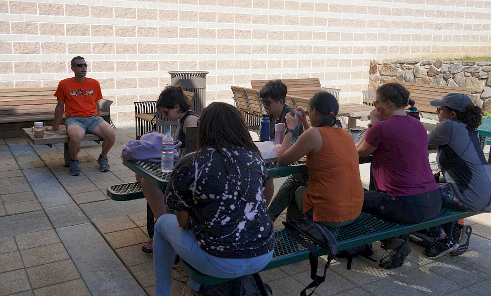 The COAST Card team met with Dr. Bob Hilderbrand at the Appalachian Laboratory to discuss changes to the forest and fish ecology of the Potomac Watershed. Photo by Pål Davidsen.
Fish populations, particularly brook trout, were originally adapted to cool, low-flow stream conditions, but as shifting land use transformed the landscape, stream waters have become warmer and flashier. These stressor have resulted in increased mortality of temperature-sensitive fish in the watershed, such as brook trout. In addition to stormwater influences, the fish have seen a decline due to pollution from coal mining. Such stressors have amounted to a 90% loss in habitable area for brook trout.
Coal mining has been a prevalent industry in the North Branch area of the watershed, taking off shortly after the Civil War. Runoff from these mines has resulted in a variety of pollutants entering nearby streams, which eventually flow into the Potomac River. This particular pollution is referred to as acid mine drainage because the runoff produces highly acidic water that reacts with its surroundings, thus eroding the streambed while also creating an inhospitable environment for biota.
One such example is Braddock Run, a stream which has been permanently stained orange-red due the presence of elevated levels of copper in the water. The stream was conveniently located adjacent to our hotel, so we were able to see the mining impacts readily. Interestingly, Dr. Hilderbrand revealed that some brook trout have adapted to living in these polluted areas because of the cooler water temperature and reduced human predation.
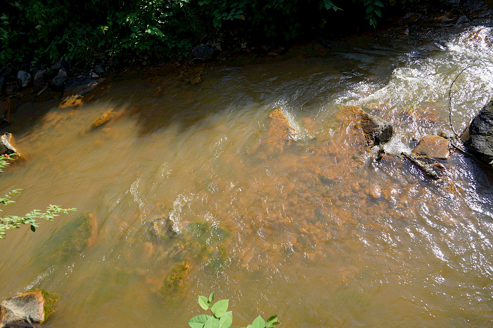 The Braddock Run stream has been polluted by coal mining which has left the stream an orange-red color. Photo by Pål Davidsen.
After meeting with Bob, we drove to the location of a coal mine and observed the plumes of dust that were emitted from the process. These particular surface mines were produced by removing mountaintops to access the coal and are known to contribute to both air and water pollution (The dirty, 2014). Out in the horizon and past the coal mines, there were several wind turbines, creating an ironic juxtaposition of old and new energy. It was almost as if the dusty coal mines were attempting to conceal the turbines, but their efforts were fruitless as the giant turbines continued to spin, disappearing any traces of dust. The looming future simply could not be ignored.
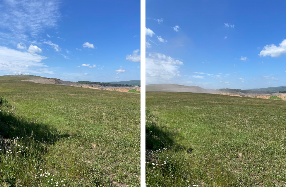
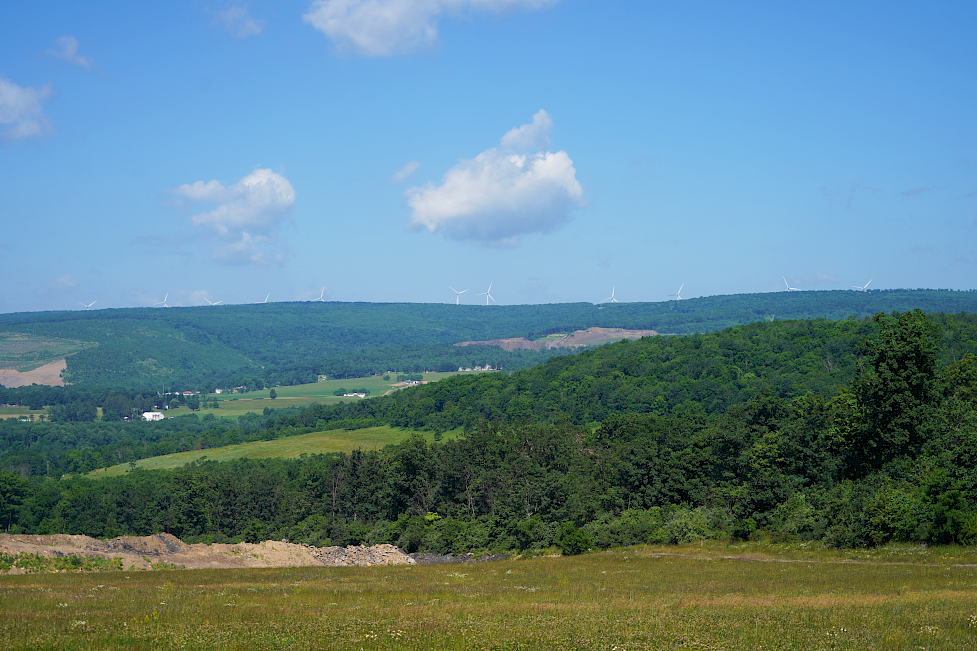 An active coal mine in Frostburg, MD (top left). While viewing the mine, it began to emit a large plume of dust (top right). On the horizon, we could see a row of wind turbines (bottom). Photos by Lili Badri and Pål Davidsen.
The next stop was Dan’s Rock Overlook, which provided a spectacular view of the mountains and the geology of the Potomac watershed. In the distance, we could see parts of the Potomac River and more coal mines. After that, we stopped at the town of Westernport, MD where we viewed the confluence of the North Branch Potomac River and George Creek. Like many other towns in the area, Westernport had a rich coal mining history; however, in present day, the mines have been abandoned and continue to contribute to water pollution. This visit was then followed by a brief stop at the Savage River Reservoir, located just northwest of Westernport. The Savage River empties into the North Branch Potomac River and is known for its pristine waters and recreational value. Its unique location in the watershed has put the river at an advantage in terms of water quality, indicating that the Potomac River Watershed also contains some unpolluted regions.
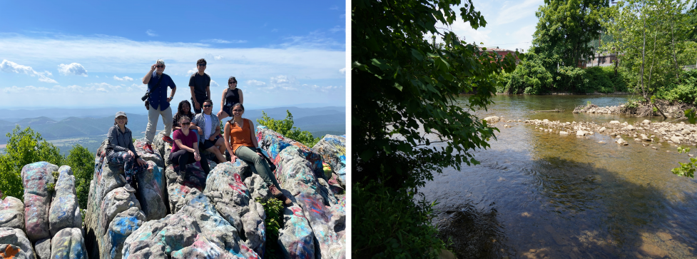 Group photo of the COAST Card team sitting atop the overlook at Dan’s Rock (left, photo by Lili Badri) and the confluence of George Creek and the North Branch Potomac River (right, photo by Pål Davidsen).
While human influences on natural history were a primary focus of our trip, it was also important to acknowledge historic human interactions in the watershed. When the Civil War moved northward into Maryland, the events that ensued led to the Battle of Sharpsburg, also known as Antietam, where nearly 4,000 soldiers were killed. We traveled to Antietam National Battlefield where we stopped at several key locations of the deadly battle. Now, the land is managed by the National Parks Service and used to grow crops such as corn.
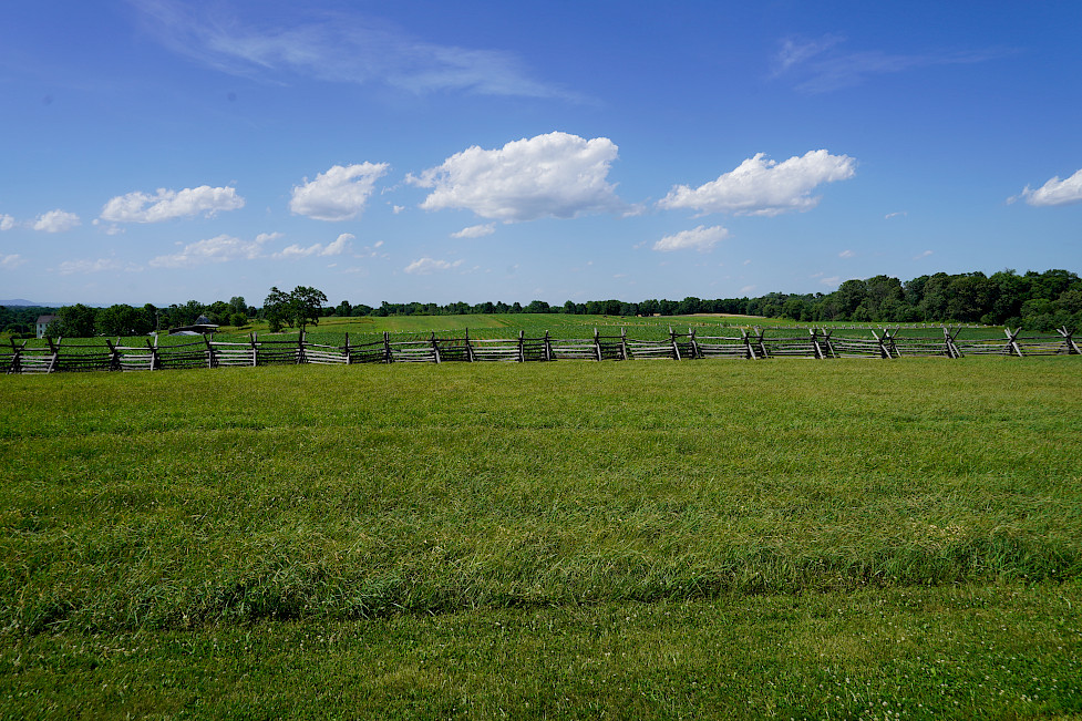 The site of one of the battlefields of Antietam. Photo by Pål Davidsen.
The last stop for the day was Harpers Ferry National Historic Park. Here, we saw the confluence of the Potomac and Shenandoah Rivers, also known as “The Point.” The economy of Harpers Ferry was originally due to its armory factory, which was destroyed at the start of the Civil War.
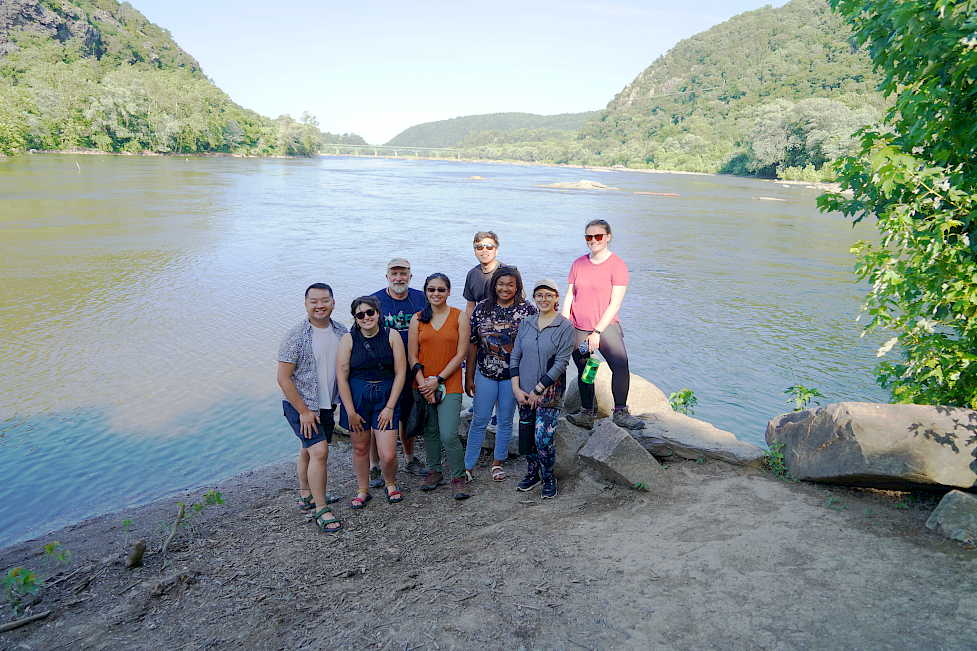 Group Photo of the COAST Card team at “The Point” in Harpers Ferry where the Potomac and Shenandoah Rivers merge. Photo by Pål Davidsen.
It was fascinating to experience so many historic locations within a short timespan. Considering the human and natural history of the area, we hope to evaluate the Potomac River Watershed using the COAST card framework. This framework includes environmental report cards, social network analysis, and system dynamics modeling. Although there have been previous report cards on the Potomac River and Watershed, the difference here is to reinforce the report cards with modeling components which can offer insight on the future of the watershed. With this work, we ultimately hope to preserve the values of the Potomac River Watershed while reducing potential threats. In hopes of engaging a wide variety of stakeholders for this project, we are hosting an open house workshop on July 21st at the Whitaker Community Commons building at Hood College from 12- 8 pm.
You can follow the COAST Card Project on these social media platforms:
Twitter, Instagram, and Linkedin
We recognize the Indigenous and native peoples who originally occupied and tended to the land and waters of what we know today as the Chesapeake Bay Watershed. The Chesapeake Bay Watershed includes the historic lands of the Accomack, Arrohatec, Chesoenhaka (Nottoway), Chesapeake, Cuttatawomen, Doeg, Ho-de-no-sau-nee-ga (Haudenosaunee), Kecoughtan, Kiskiack, Lənape Haki-nk (Lenni-Lenape), Lumbee, Manahoac, Massawomeck, Monacan, Nacotchtank (Anacostan), Nandtaughtacund, Nansemond, Nentego (Nanticoke), Occohannock, Onawmanient, Onöndowa'ga:' (Seneca), Pamunkey, Patawomeck, Piscataway, Pissaseck, Pocomoke, Powhatan, Quiyoughcohannock, Rappahannock, Sekakawon, Susguehannock, Warraskoyack, and Youghtanund.
References
- Potomac Basin facts. ICPRB. (2022, February 23). Retrieved from https://www.potomacriver.org/potomac-basin-facts/
- The dirty effects of mountaintop removal mining. (2014, October 21). Washington Post. Retrieved from https://www.washingtonpost.com/opinions/the-dirty-effects-of-mountaintop-removal-mining/2014/10/21/851c4236-58a2-11e4-bd61-346aee66ba29_story.html.
About the author
Lili Badri

Lili is a Senior Science Communicator at the University of Maryland Center for Environmental Science’s Integration and Application Network (IAN). Her work at IAN focuses on the synthesis and dissemination of scientific information through data analysis, visualization, and stakeholder engagement. She collaborates within and across disciplines to develop accessible communication products that support evidence-based decision-making. Her professional interests include enhancing science communication practices and understanding community perspectives to support sustainable and informed environmental solutions. She earned a Master's degree in Environmental Science at SUNY ESF and a Bachelor's degree in Chemistry at the University of South Alabama. Her previous research focused broadly on lab and field analysis of dissolved organic matter characterization and dynamics. Her personal interests include gardening, reading, and cooking.