

Journey Through the City
Ashley Silver ·The premise of our class meeting on April 30, 2021 was to begin the process of engaging stakeholders on environmental justice indicators for the Chesapeake Bay watershed. Dr. Bill Dennison started the discussion by asking two questions in regards to the student’s’ presentation on “Developing an environmental justice index for the Chesapeake watershed report,”shown at the Scientific, Technical Assessment and Reporting (STAR) Team Meeting held on April 22, 2021. The questions were, “What did you see there that resonated with you?” and “What did we miss?”
The first response was from Mark Nardi, Supervisory Geographer at USGS. He replied, “I saw a point map of BMP data in the presentation and needed it for the USGS work.”
In the midst of sitting at my dining room table and listening in on other responses, I noticed we were getting input on environmental injustices. These are injustices seen mostly by people of color, and yet none of our guest speakers were people of color. I find it hard to value input from someone who doesn't face the challenges we face on a daily basis. It's more authentic when I’m listening to someone who has walked in my metaphorical shoes. Lou Etgen, Executive Director of the Gunpowder Valley Conservancy, gave a statement that echoed this issue, he said:
“We have been having the same conversations in our offices for the better part of 15 years about how to become more diverse, how do we make sure we are working in underserved communities. Traditionally it's white people that are my age and older sitting around having these conversations.”
This comment further confirmed my feeling towards the lack of inclusion of people of color within these organizations.
I can say I respect a question asked by Mark Nardi, he asked “How to have conversations as a white male with people who are subjected to environmental injustices?” He had follow-up responses from my fellow classmates and other guest speakers:
- Faith Taylor responded with, “Take initiative to educate yourself on the topic, there is published writing available for people to educate themselves.”
- Bill Dennison responded with, “Having the historical context gives a better understanding of environmental issues in African American communities.”
- Brad Rogers responded with, “A deeper historical understanding of the realities of the place that you are in is essential to know what to do next.”
Listening to the discussion gave me an idea for my blog. I wanted to show environmental injustices seen in predominantly Black communities in the city that I call my new home.
Flashback
I'm originally from the Hampton Roads area of Virginia and I lived there for 33 years. Since I lived there for many years I knew the area, however, I didn’t know the details of the communities within the cities of Hampton Roads. Recently, I relocated to Salisbury, Maryland—a few months before everything shut down due to the COVID-19 pandemic. As I was exploring my new home, I became more observant of my surroundings and community.
Being new to the area, I wanted to take my son to explore our new community. I would take my son for a ride to different neighborhoods in the city. That was the most we could do since most stores were shut down. After a few trips around the city I noticed something different between neighborhoods that I didn’t quite notice when I lived back in Virginia.
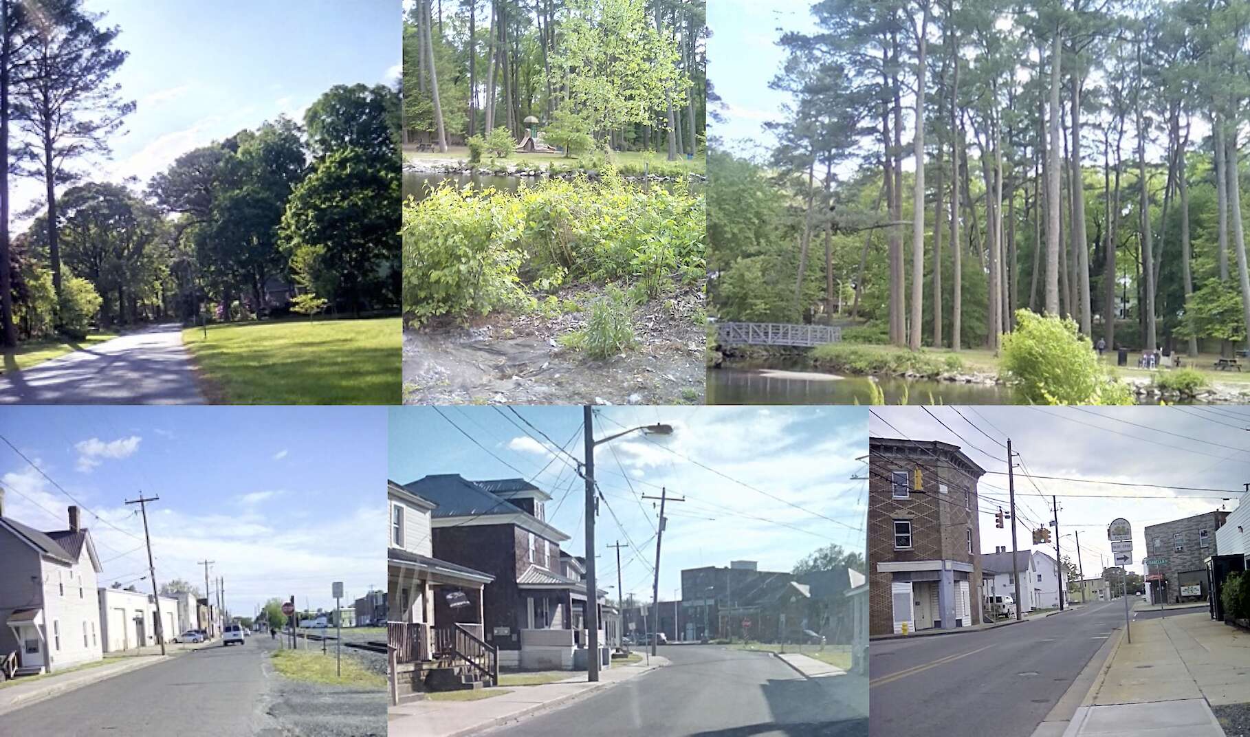
The difference I noticed was that you can clearly see the separation between predominantly Black neighborhoods and predominantly white neighborhoods. The predominantly white neighborhoods had lush green spaces and beautiful waterfront properties. However, one thing I did not see in these neighborhoods was even one child outside of their home enjoying the privileges bestowed upon them. In contrast, the predominantly Black neighborhoods have more pavement and older, not-well-kept homes. In these neighborhoods, I saw children playing basketball and children sitting on the curb eating popsicles, enjoying their day. One of the many things I love about being part of the Black community is we make the best out of any situation.
Now
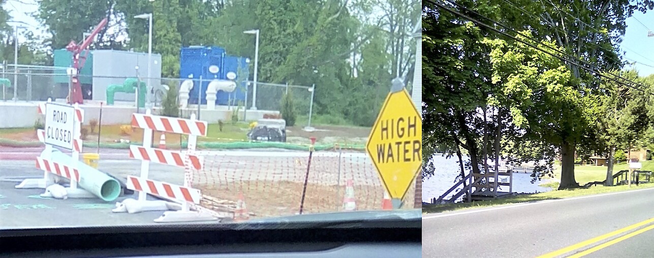
Taking this environmental justice course opened my eyes to differences I didn't notice at first, one example being I learned that beautiful homes with a lot of greenery in the predominantly white neighborhoods are on elevated lands, and the older homes in the predominantly Black neighborhoods are in flood zones. I’ve actually seen this disparity in real life; Fitzwater Street has had a detour sign up for at least a year, along with cones and high water signs that block off a portion of the street. This street repair project was part of a development plan from 2014. It took seven years to break ground for one street.
I took these next pictures myself to show the visuals of my journey through the city. I would like for you to take a look at the following collages to see if you can determine which pictures were taken in the predominantly white communities and predominantly Black communities. One picture may surprise you!!!
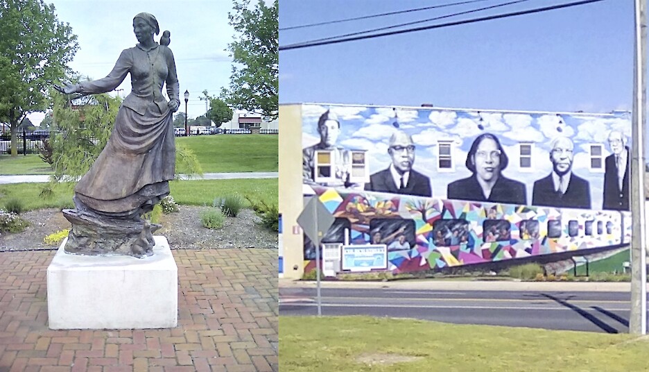
Also, links to the backstory of the mural and statue of Harriet Tubman:
http://sbynews.blogspot.com/2019/05/mural-artist-selected-for-church.html
https://wanderwomenproject.com/places/harriet-tubman-statue-in-salisbury-md/
About the author
Ashley Silver
Ashley Silver is a second year PhD student in the Marine Estuarine Environmental Sciences program at University of Maryland Eastern Shore, with a concentration in Ecological Systems. She works under the guidance of Dr. Paulinus Chigbu. Her research focuses on comparing how juvenile fish species utilize Maryland Coastal Bays and Maryland Coastal Ocean as nursery grounds. Also, Ashley is an active member of the American Fisheries Society UMES Subunit.