Lower Kafue River Environmental Literacy
Heath Kelsey ·In February 2018, Simon Costanzo, Michele Thieme and I travelled to Lusaka, Zambia to kick off a project to develop an ecosystem health report card for the Lower Kafue River Basin. We provided training for the WWF Zambia team on the report card creation process. I then traveled with the WWF team to Monze in the Southern Province to help the team facilitate first stakeholder workshop. As part of the report card process, it is imperative that we have an understanding of the relevant information about the system in which we are working.
The Kafue River is the most important river system in Zambia. It flows about 1600 km from the Northwest Province near the border with the Democratic Republic of Congo, south through the southern central portion of Zambia. The river turns East at Kafue National Park (Zambia’s oldest and largest protected area), emptying into the Zambezi, which forms the border of Zambia and Zimbabwe. About 50% of the country’s 16.6 million people live within the river’s catchment of 156,000 km2.
There are several features of the Kafue River that make it environmentally, economically, and socially important:
1. The Kafue River is a major tributary to the Zambezi River, southern Africa’s most iconic river system. It averages about 350 cubic meters per second (Draft of Kafue Management Plan, in preparation).
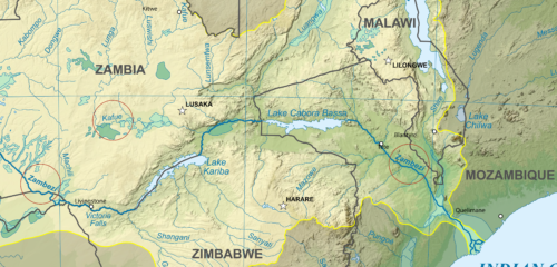
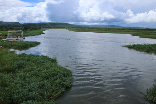
2. The Lower Kafue River is home to the Kafue Flats, recognized by Ramsar as a Wetland of International Importance, is approximately 6,500 square kilometers with a water volume of about 785 million cubic meters. The Kafue flats are situated between two dams – the upstream Itezhi-Tezhi dam completed in 1977 primarily for regulation of water flow (the Itezhi-Tezhi has been producing electricity since 2016), and the Kafue Gorge Dam downstream, which was completed in 1973 to produce hydropower.
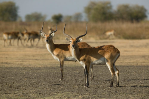
3. The Kafue Flats are home to an endemic, semi-aquatic antelope called the Kafue Lechwe (Kobus leche kafuensis). The population of the Kafue Lechwe has declined dramatically since the 1970s, as a result of hydrologic changes, poaching, disease, and invasive grasses. The historical population is said to have been approximately 250,000 in 1931, but was estimated at approximately 29,000 in 2015. Anecdotal evidence suggests that declines since 2015 have been accelerating, and there are fears that the species could become extinct. The Kafue Lechwe is listed as Endangered by the IUCN.
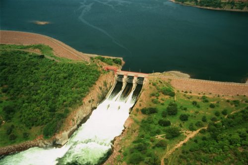
4. Hydropower provided by the Kafue Gorge Dam, constructed in 1973, provides approximately 50% of Zambia’s electricity needs, including power for the copper mines in the northern part of the country. The Itezhi-Tezhi dam was constructed primarily to ensure that adequate water was available for power generation at the Kafue Gorge dam and now produces 120MW.
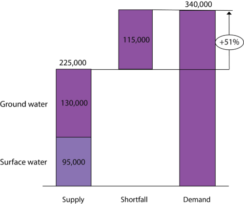
5.The Kafue River provides 84 million cubic meters of domestic water for Lusaka, the capital of Zambia, a city of 1.7 million people. This accounts for approximately 44% of water supply. Approximately 56% of the water supply in Lusaka is met by groundwater sources.
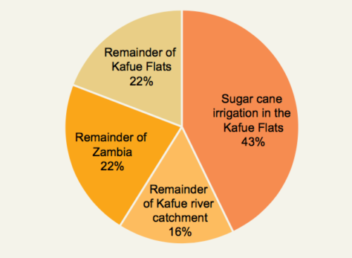
6. The Kafue River is a major source of irrigation water for agricultural activities in the region, including the economically important Zambia Sugar Plc (a subsidiary of Llovo Sugar), which produces approximately 450,000 tons of sugar annually (of which 1/3 is exported to Europe), employing 1082 permanent employees and over 4,000 seasonal employees. The Kafue River accounts for over 80% of irrigation for the nation; the Kafue Flats accounts for 61% alone. Zambia Sugar accounts for 43% of the national irrigated area. Unpermitted irrigation is an area of concern for water resource management in the basin.
7. The Kafue River also provides resources for small holder agricultural activities, primarily maize, as well as fisheries, cattle, and tourism. Maize is an important staple ingredient of nshima, which is a corn meal eaten at almost every meal. 80% of maize in Zambia is grown by small landholders without irrigation, and almost all of that is for home consumption (WWF Zambia 2016). Fisheries are a relatively small part of the economy, but represent a relatively large component of protein intake for the Zambian people. Livestock account for a slightly larger percentage of the national GDP, mostly in traditional (not commercial) enterprises. Pastoralism is an important cultural value in the basin. Tourism represents approximately 5% of the national GDP, but that number is expected to grow rapidly (WWF Zambia 2016).
References:
1. WWF Zambia 2016. Water in the Zambian Economy. Exploring shared risks and opportunities in the Kafue Flats.
2. WWF 2017. Kafue Flats Status Report. Monitoring the pulse of the blue heart of Zambia’s economy.
About the author
Heath Kelsey

Heath Kelsey has been with IAN since 2009, as a Science Integrator, Program Manager, and as Director since 2019. His work focuses on helping communities become more engaged in socio-environmental decision making. He has over 10-years of experience in stakeholder engagement, environmental and public health assessment, indicator development, and science communication. He has led numerous ecosystem health and socio-environmental health report card projects globally, in Australia, India, the South Pacific, Africa, and throughout the US. Dr. Kelsey received his MSPH (2000) and PhD (2006) from The University of South Carolina Arnold School of Public Health. He is a graduate of St Mary’s College of Maryland (1988). He was also a Peace Corps Volunteer in Papua New Guinea from 1995-1998.

