Water, food webs, and production on the Kakadu floodplains
Heath Kelsey · | Science Communication | Applying Science | Learning Science |As part of our synthesis of research findings related to National Environment Research Programme (NERP) work on Kakadu National Park floodplains, I am interviewing scientists to begin distilling the key messages for the synthesis story. These researchers are contributing to the developing picture of the connections between the floodplains, water movement, and important natural and cultural resources.

The key elements of the research in Kakadu have to do with the connectedness of the rivers with their floodplains and coasts, and the implications of this connectedness on the important resources and features that are found there. Any effects on these systems from invasive species, sea level rise, and climate change will be mediated through these connections.
Perhaps the most foundational piece of this “connectedness puzzle” has to do with the way water and energy move through the rivers, estuaries, coastal areas, floodplains, and swamps through physical and ecological processes.

A team of researchers has been studying these processes on the South and East Alligator rivers, and Magela Creek, all within Kakadu National Park. The team includes Drs. Stuart Bunn, Doug Ward, Fernanda Adame, and Tim Jardine at Griffith University, Drs. Michael Douglas, Erica Garcia, David Crook, and Peter Kyne at Charles Darwin University, Drs. Peter Davies, Brad Pusey, and Neil Pettit at University of Western Australia, and Dr. Renee Bartolo at the Environmental Research Institute of the Supervising Scientist.
Key findings from this research include
- Energy derived from the floodplain supports the high biodiversity and richness found in waterholes and hydrologic connectivity between waterholes and floodplains is critical for the maintenance of aquatic food webs. Larger animals are reliant on more diverse food sources outside of the waterholes.
- Algae that grows on vegetation provide the most important energy source for aquatic animals. Plants, especially submerged species such as Ceratophyllum that have complex branching and submerged or horizontal structures, provide the most substrate for algae. Conversely, invasive grasses with vertical stem structures such as Olive hymenachne and para grass limit light penetration leading to reduced algal growth, as do some native species like wild rice and native species of hymenachne.
- Backswamp areas that are inundated for longer periods and maintain high abundance of attached algae provide important hot spots for biodiversity and refuge areas for animals and plants well into the dry season.
- There is limited energy transfer between waterholes as a result of fish returning to their home billabongs at the end of the wet season.
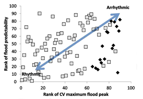
To provide context on a global scale, the researchers compared the predictability of flood timing and magnitude of northern Australian rivers with other major global river systems, including tributaries of the Amazon River. The analysis suggests that Australian rivers are quite variable in flood magnitude from year to year, and while the timing of floods in some regions is predictable, it is highly variable in others. Overall, rivers that have more predictable flood timing and magnitude (“Rhythmic” systems) have higher biodiversity and productivity, and (perhaps) resilience, than rivers with floods that are less predictable (“Arrhythmic” systems).

Kakadu rivers have intermediate rhythmicity on a global scale, with predictable flood timing and magnitude relative to other Australian rivers such as dryland Cooper Creek, but less predictable floods than those in tributaries of the species-rich Amazon. This makes the high biodiversity of Kakadu somewhat vulnerable to the combined effects of climate change and water extraction; water extraction during an already low water wet season would exacerbate pressure on resources dependent on an inundated floodplain.
The research on energy movement within the ecosystem reinforces the idea that the important cultural and recreational resources available in Kakadu rivers are dependent on energy derived from sources outside the rivers and waterholes, including the inundated floodplain. Isotope analysis suggests that the most important source of energy for the aquatic food web, particularly for larger fish, is derived from algae growing on aquatic vegetation.

Additionally, production from these algae is highest in areas with complex submerged vegetation, in deeper, clearer waters. Plants that have complex and horizontal structures provide the most substrate for algae such as submerged plants including Ceratophyllum demersum and Urticularia spp and the aquatic grass Psuedoraphis spinescens. That is, these plants effectively create a “false bottom” in the deeper waters of the floodplain. They form a layer of submerged macrophyte 5-20 cm below the clear water surface, and function in a similar way to the littoral zone except that because of their complex architecture they provide a greater access to light and number of sites for algal attachment and therefore higher production of periphyton than comparatively uniform benthic surfaces. This in effect greatly increases the area of the littoral zone, reaching all parts of the floodplain where these submerged plants occur. The research suggests that this significantly boosts algal production within the flooded floodplain.
Instead, invasive species with vertical stem structures such as olive hymenachne and para grass provide poor substrate for algal growth and grow at high density compared to many native species. These species tend to grow in dense swards that exclude light, and their simple, vertical structure make them less than ideal areas for algal growth. Additionally, native emergent species like wild rice and native hymenachne species are increasing in area and forming more of a monoculture in some areas – there is some speculation that changes in burning schemes and reductions in buffalo have created a resurgence of these grasses.
Dry season burning of the floodplain is an important management tool in Kakadu National Park and in particular traditional indigenous patch-burning practices that create open areas on the floodplain which are likely colonized by submerged aquatic plants and thus areas of high algal growth.

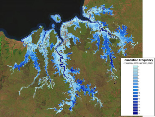
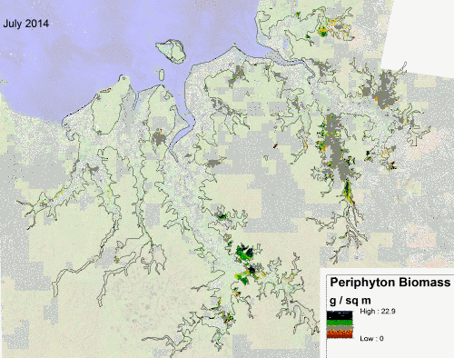
Using remote sensing tools that estimate productivity from vegetation, inundation frequency, and water depth, detailed maps of high productivity areas were prepared to assist management in identifying high priority areas in terms of productivity and refuge for fish well in to the dry season. Areas of open water without emergent species provide good conditions for submerged vegetation supporting high algal growth. These conditions are thought to be enhanced by burning in previous years.

This research is closely linked to work on fish movement and invasive grasses, which has been described in previous posts. The findings from all of these research efforts are the pieces, that when fitted together, form the key messages and information that managers need for park management.
Reference:
Stuart Bunn, Doug Ward, Brad Pusey, Tim Jardine, Michael Douglas, Erica Garcia, Peter Kyne, Peter Davies, Neil Pettit and Renee Bartolo. 2015. Tropical floodplain food webs connectivity and hotspots; Final report.
About the author
Heath Kelsey

Heath Kelsey has been with IAN since 2009, as a Science Integrator, Program Manager, and as Director since 2019. His work focuses on helping communities become more engaged in socio-environmental decision making. He has over 15-years of experience in stakeholder engagement, environmental and public health assessment, indicator development, and science communication. He has led numerous ecosystem health and socio-environmental health report card projects globally, in Australia, India, the South Pacific, Africa, and throughout the US. Dr. Kelsey received his MSPH (2000) and PhD (2006) from The University of South Carolina Arnold School of Public Health. He is a graduate of St Mary’s College of Maryland (1988), and was a Peace Corps Volunteer in Papua New Guinea from 1995-1998.