

International Riversymposium 2013
Brisbane, Australia | 23-26 September 2013. The International Riversymposium is a world-renowned annual conference focused on a holistic approach to river and water management. Rivers and other freshwater systems are central in the production of food and many forms of energy. The 16th International Riversymposium provides an opportunity to look at the linkages that rivers provide to water-energy-food. Early bird registration closes July 22nd.2012 Chesapeake Bay report card
 This report card provides a transparent, timely, and geographically detailed assessment of Chesapeake Bay. In 2012, the methods for the report card have changed to include five water quality indicators and two biotic indicators. In 2012, the overall grade for Chesapeake Bay is a 47%, a C. This means the Bay is in moderate health. Fisheries indicators as well as trajectories of reporting region health are also presented. For further details, visit the Report Card website.
Chesapeake Bay dissolved oxygen forecast for summer 2013
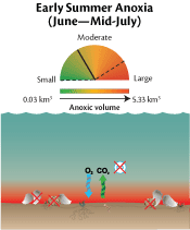 For the past several years, Chesapeake Bay scientists have collaborated with the Integration and Application Network to forecast Chesapeake Bay summer dissolved oxygen conditions, based on flow and nutrient loading conditions through May. Ecological forecasts provide resource managers with information that can be used to guide restoration, enable proactive communication of Bay conditions, and help direct research activities. The average summer (June to September) hypoxia forecast predicts better than average conditions for 2013. This forecast is based on Susquehanna River flow (January to May) and wind direction and speed across the Bay.
Updating Maryland's sea-level rise projections
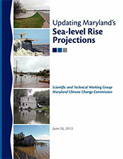 With 3,100 miles of tidal shoreline and low-lying rural and urban lands, 'The Free State' is one of the most vulnerable to sea-level rise. Historically, Marylanders have long had to contend with rising water levels along the Chesapeake Bay, Atlantic Ocean, and Coastal Bay shores. Shorelines have eroded and low-relief lands and islands (some previously inhabited) have been inundated. Prior to the 20th century, this was largely due to the slow sinking of the land since the Earth's crust is still adjusting to the melting of large masses of ice following the last glacial period. Over the 20th century, however, relative sea-level rise (how much the average level of tidal waters has risen with respect to land) has increased, at least partially as a result of global warming. This report interprets recent scientific results to produce projections useful for sea-level rise adaptation in Maryland.
Maryland Coastal Bays report card 2012
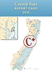 The aim of this report card is to provide a transparent, timely, and geographically detailed assessment of 2012 Coastal Bays health. Coastal Bays health is defined as the progress of four water quality indicators (total nitrogen, total phosphorus, chlorophyll a, dissolved oxygen) and two biotic indicators (seagrass, hard clams) toward scientifically derived ecological thresholds or goals. These six indicators are combined into one overarching Coastal Bays Health Index, which is presented as the report card score. Detailed methods and results are available on the EcoCheck Coastal Bays report card website. The overall score for the Coastal Bays was a C+ in 2012, with a slight improvement since 2011.