

Assessment of Natural Resource Condition, Assateague Island National Seashore
 Wednesday, December 17 was the kick-off meeting for the Assateague Island National Seashore assessment project. The meeting was attended by staff from IAN (Bill Dennison, Tim Carruthers, Michael Williams, and Jane Thomas) and Horn Point Laboratory (Tom Fisher and Greg Radcliffe), as well as National Park Service personnel, with the aim of categorizing habitats within the park and identifying appropriate data sets and sources to begin the assessment.
Assateague Island National Seashore Natural Resource Condition Assessment
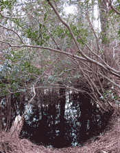
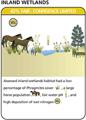
 Assateague Island National Seashore with lands and waters in Maryland and Virginia receives some two million visitors per year. After determining key habitats on Assateague Island, potential indicators were identified and data sourced. Attainment of reference condition was assessed for each metric and summarized by habitat and ultimately for the whole park. Based on these key findings, management recommendations were developed. Overall, the natural resources of Assateague Island National Seashore were assessed to be in fair condition. While salt marsh, forest and shrubland habitats were assessed to be in degraded condition, inland wetlands, dunes and grasslands were assessed as fair, bay subtidal and mudflats, beach and intertidal to be in good condition and Atlantic subtidal to be in very good condition.
UMCES researchers attend biennial Coastal and Estuarine Research Federation Conference
 IAN and UMCES researchers attended the biennial Coastal and Estuarine Research Federation's conference in Daytona Beach, Florida in early November 2011. This international conference brings together all the diverse disciplines within coastal and estuarine science, such as geochemistry, physical oceanography, biological systems, management, and education. Several IAN researchers presented on their integrated assessments of Baltimore Harbor, National Park Service parks, and the Great Barrier Reef, as well as attended plenary and poster sessions.
Restoration of overwash processes creates piping plover habitat on a barrier island paper
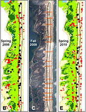 On Assateague Island, an undeveloped barrier island, a foredune was constructed to protect the island from the erosion and breaching threat caused by permanent jetties. The foredune unexpectedly acted as near-total barrier to both overwash and wind, and the dynamic ecosystem underwent undesirable habitat changes including conversion of early-succession beach habitat to herbaceous and shrub communities, and diminishing availability of foraging habitat, thereby reducing productivity of the threatened piping plover. To address these impacts, multiple notches were cut through the constructed foredune. New overwash fans increased island stability by increasing interior island elevation. At every notch, areas of sparse vegetation increased and the new foraging habitat was utilized by breeding pairs.
Improving management of a Mid-Atlantic coastal barrier island through assessment of habitat condition
 To achieve desired environmental outcomes, conditions and trends need to be measured and communicated. However, there is often a disconnect between responsive ecosystem monitoring and decision-making for strategic long-term management. Recently published in Estuarine, Coastal and Shelf Science, this paper demonstrates how historical monitoring data can be used to inform integrated resource management decision-making at Assateague Island National Seashore by using ecological reference conditions to identify monitoring needs, areas of high vulnerability, and areas with potential for improved management. This approach provides a framework that can be applied to assess the effectiveness of these management decisions on the condition of island habitats, and demonstrates effective incorporation of diverse monitoring datasets into an adaptive management cycle.