

IAN and UMCES staff engage stakeholders at Tennessee River Basin Network meeting
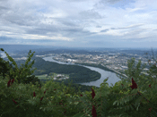 Heath Kelsey, Bill Dennison, and Dylan Taillie of the Integration and Application Network and Eric Davidson and Andrew Elmore of UMCES Appalachian Lab traveled down to Chattanooga in mid-August to engage Tennessee River Basin Network members in the report card process. During the workshop, participants identified values and threats to the Tennessee River Basin and drafted the regions of the basin so local stakeholders would feel empowered by the report card results. The Tennessee River Report Card will be released in the late Fall of 2017. Read more about the Chattanooga trip here.
UMCES releases the Tennessee River Basin Report Card
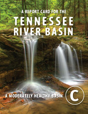 IAN and Appalachian Laboratory teamed up with the Appalachian Landscape Conservation Cooperative and the Tennessee River Basin Network to produce the first ever Tennessee River Basin Report Card. The Tennessee River Basin received an overall grade of C. The report card took a pressure, state, response approach to assessing the health of the region, finding the biggest threats to be aquatic and forest habitat fragmentation and land based sources of pollution. Read more about the report card process in Bill's blog here, and dig into the methods of the report card here.
IAN attends Tennessee River Basin Network planning meeting
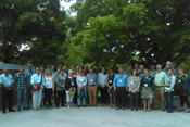 Heath Kelsey spoke at the annual Tennessee River Basin Network planning meeting in Knoxville, TN on August 13-14, about the next steps for the Tennessee River Report Card, which was released in February this year. One key item up for discussion was how to best use the report card as an outreach and awareness tool to highlight key issues in the basin. Data visualizations contained in the report card and methods document can also be used to prioritize particular areas of concern for soil erosion, forest protection, etc. The report card project also needs a local home and several organizations expressed interest in hosting or participating.