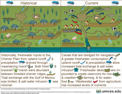
Diagram showing hydrology on the Chenier Plain of coastal Louisiana
Diagram showing hydrology on the Chenier Plain of coastal Louisiana.
diagram Louisiana Mississippi delta chenier plain hydrology ecosystems sediment| Property | Value |
|---|---|
| Author(s) | Jane Thomas |
| Author Company | Integration and Application Network |
| Date Created | 2006-07-25 |
| Album | Ecosystems > Coastal/Marine |
| Type | Graphic |
| Publication | Enhancing Landscape Integrity in Coastal Louisiana: Water, Sediment & Ecosystems |
| Project(s) | Louisiana Sea Level Rise |
| Dimensions | 1000 x 770 |
| Filesize | 278.6 kB |
| Number of Downloads | 367 |
| Filetype(s) | PNG |
| License | Attribution-ShareAlike 4.0 International (CC BY-SA 4.0) |
| Required Attribution | Jane Thomas, Integration and Application Network (ian.umces.edu/media-library) |