

An Adventure Along the Potomac
Anna Calderón and Lawren Caldwell ·“A watershed – the land area that drains to a stream, lake, or river – affects the water quality in the water body that it surrounds. Healthy watersheds not only help protect water quality, but also provide greater benefits than degraded watersheds to the people and wildlife that live there. We all live in a watershed, and watershed conditions are important to everyone and everything that uses and needs water.” (1) – The Environmental Protection Agency.
June 16th marked the beginning of our two-day long excursion throughout the beauty that is the Potomac Watershed. According to the Interstate Commission on the Potomac River Basin, the Potomac stretches across the states of Maryland, Pennsylvania, Virginia, and West Virginia (2). It is the second largest watershed within the Chesapeake Bay.
With that, our journey consisted of visiting the different stages of the river, from the Potomac’s headwaters on down. One of our destinations included Finzel Swamp Preserve, located in Frostburg, Maryland. According to Maryland’s Department of Natural Resources, the swamp is home to more than 30 rare uncommon species, and five globally and locally significant wetland types (3). We immersed ourselves in the natural surroundings of the swamp and observed all the different types of organisms that reside in the region. We trekked through its tall grasses and muddy passageways to reach the calm and serene headwaters of the Potomac. The water was almost crystal clear and clean as could be.
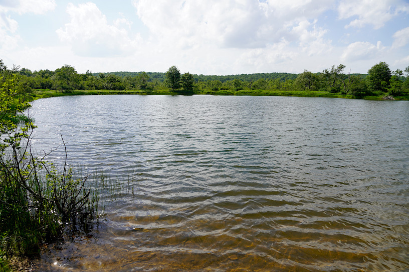
A clear-watered pond, deep within the Finzel Cranberry Swamp, features ripples along its surface on a breezy day, looking out onto a lush green forest. Photo by Pål Davidsen.
Our voyage continued as we traveled along the river’s meandering path. After a while, we reached the intersection at which the Potomac’s waters quietly converge with the still waters of George’s Creek. Wading through the creek’s waters, we basked in its serenity.
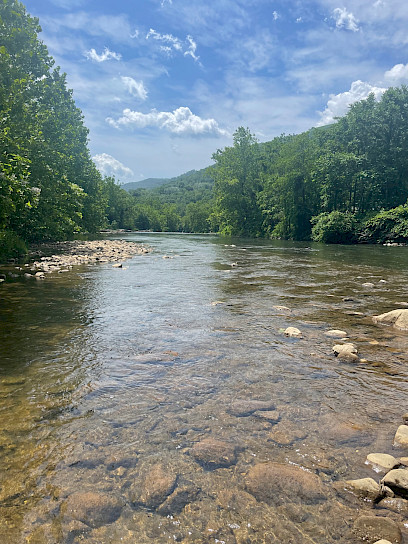
In Westernport, Maryland, lush forest surrounds the confluence of Georges Creek and the Potomac River. Bubbling and dipping around stones in its path, the water runs onward calmly. Photo by Lawren Caldwell.
Our final destination was Harper’s Ferry National Historical Park, where the Potomac meets the Shenandoah. As the water rushed down the reservoir, the rivers met smoothly, allowing for a gentle union.
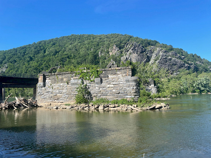
The Potomac and Shenandoah rivers converge at Harper’s Ferry National Historical Park. In the center of the streambed, a large stone arch overlooks the calm water rushing around it. Photo by Lawren Caldwell.
While exploring the region, we had the opportunity to meet at the Appalachian Lab with two UMCES professors working within the Potomac Watershed: Dr. Xin Zhang and Dr. Bob Hilderbrand. Our first meeting was with Dr. Zhang and members of her lab. Dr. Zhang’s work focuses on using data driven, transdisciplinary approaches to guide the pursuit of sustainable agriculture. Utilizing the Sustainable Agriculture Matrix (SAM), scientists and agriculturalists can use a variety of indicators to support nutrient management beyond crop farms, consider nutrient management across system and spatial scales, and identify socio-economic factors that affect nutrient loss surplus and use efficiency.

The “SAM Consortium”, referenced on the slide, is “an interdisciplinary, multinational collaborative of researchers interested in applying, strengthening and disseminating SAM”, which is the “Sustainable Agriculture Matrix.” Picture by Pål Davidsen.
The next morning, we met with Dr. Hilderbrand for a discussion on the environmental biome of the Potomac. As we all sat outside, he told us the miraculous story of the once plentiful chestnut and hemlock forests that graced the region, histories of acid mine drainage, the iconic local brook trout, and stream restoration efforts.
The landscape around the Upper Potomac used to look a lot different – there were extremely wide chestnut and hemlock trees resting in soil that was meters thick. Then, it was very rare for there to be high flow levels. Now, with most of that soil gone and runoff from impermeable surfaces rampant, high flow is common within the Upper Potomac. Acid rain and acid mine drainage from unregulated mining practices has left the world-famous brook trout population sensitive and far smaller, which cannot be restocked due to concerns over population genetics.
Holding close ties to contamination and acid mine drainage, the past and present impacts of regional coal mining on the Potomac’s waters was a focus of our field trip. Since coal mining began in Maryland in the 1800s, it has played a crucial role in Western Maryland’s economy (4). Despite the monetary benefits of mining that continue today, there has been sweeping ecological damage wreaked by mining activity – particularly before 1977. At that time, regulations on mining were put in place for the sake of public and environmental health (5).
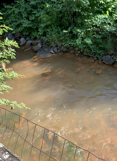
Right next to the hotel we had stayed in, Braddock Run’s water appeared a bright orange color, tinting the rocks in the streambed the same color as a result of acid mine drainage in the region. Photo by Anna Calderón.
Acid mine drainage – the main culprit at work – is a process where mine waste containing pyrite, “fool’s gold”, reacts with air and water to form dissolved iron and sulfuric acid, which is extremely corrosive and hazardous to waterways. The corrosive, bright, orange-tinted water can dissolve harmful heavy metals and leach them into ground and surface water. This disrupts the life cycle of aquatic organisms, corrodes infrastructure around the contaminated stream, and contaminates drinking water (6).
Although there are some state-wide monitoring and treatment systems in place, you can see contaminated, neon orange water at different points along the Upper Potomac. Though coal mining is still active and economically significant to the region, seeing the river’s bright orange hue was shocking and unsettling.
Dr. Hilderbrand painted a picture of a sensitive Potomac – one that requires increased stream restoration efforts, removing impervious surfaces, decreasing the amount of road salt used, and avoiding runoff. In addition – as we discussed with Dr. Zhang – efforts also need to be made towards sustainable agricultural practices as poor nutrient management and a lack of assessment for nutrient loads contribute to wastewater runoff, which in turn negatively affects the quality of water in the region. Traveling along the river’s path and seeing its histories, ecosystems, and issues first hand truly emphasized the importance of watershed restoration and protection. Efforts to monitor, assess, and address issues are essential to maintaining the biodiversity and beauty of the river, and must be amplified. If not, the Potomac’s water and aquatic species may endure lasting harm.
We recognize the Indigenous and native peoples who originally occupied and tended to the land and waters of what we know today as the Chesapeake Bay Watershed. The Chesapeake Bay Watershed includes the historic lands of the Accomack, Arrohatec, Chesoenhaka (Nottoway), Chesapeake, Cuttatawomen, Doeg, Ho-de-no-sau-nee-ga (Haudenosaunee), Kecoughtan, Kiskiack, Lənape Haki-nk (Lenni-Lenape), Lumbee, Manahoac, Massawomeck, Monacan, Nacotchtank (Anacostan), Nandtaughtacund, Nansemond, Nentego (Nanticoke), Occohannock, Onawmanient, Onöndowa'ga:' (Seneca), Pamunkey, Patawomeck, Piscataway, Pissaseck, Pocomoke, Powhatan, Quiyoughcohannock, Rappahannock, Sekakawon, Susguehannock, Warraskoyack, and Youghtanund.
References:
- United States Environmental Protection Agency. (2016, October 24). Healthy Watersheds Overview. Healthy Watersheds Protection. Retrieved from https://19january2017snapshot.epa.gov/hwp/healthy-watersheds-overview_.html
- Interstate Commission on the Potomac River Basin. (2022, February 23). Potomac Basin facts. Interstate Commission on the Potomac River Basin. Retrieved from https://www.potomacriver.org/potomac-basin-facts/
- Maryland Department of Natural Resources. Finzel Swamp, Garrett County. Maryland's Natural Areas. Retrieved from https://dnr.maryland.gov/wildlife/Pages/NaturalAreas/Western/Finzel-Swamp.aspx
- Maryland Department of the Environment. Acid Mine Drainage Remediation Efforts in Western Maryland. Acid Mine Drainage Abatement Section. Retrieved from https://mde.maryland.gov/programs/LAND/mining/Pages/AcidMineDrainageSection_AMDS.aspx
- Maryland Department of the Environment. NonCoal Mining. The Maryland Mining Program's Minerals, Oil, and Gas Division. Retrieved from https://mde.maryland.gov/programs/land/mining/pages/mog.aspx
- United States Geological Survey. How does mine drainage occur? Frequently Asked Questions – Water. Retrieved from https://www.usgs.gov/faqs/how-does-mine-drainage-occur
Blog written by: Anna Calderón and Lawren Caldwell

Anna is a Global Sustainability Scholar and is working on the transnationally-focused COAST (Coastal Assessment for Sustainability and Transformation) project based at UMCES. Anna is passionate about addressing water scarcity, understanding hydrological systems in light of climate change, and participating in serendipitous community-based science. She is a senior at Wellesley College (Class of ‘23) majoring in Geoscience and Anthropology with a special interest in hydrogeology. Anna’s contact information is asofiacalderon5@gmail.com.

Lawren is a Global Sustainability Scholar working alongside UMCES and IAN staff on the Coastal Ocean Assessment for Sustainability and Transformation (COAST Card) project. Her passions include advocating for marginalized communities affected by environmental disparities and increasing minority representation within the natural sciences. She is pursuing her baccalaureate at North Carolina A&T State University studying Agricultural and Environmental Systems with a concentration in Environmental Studies.