Brisbane 2011: Living with Floods and Dancing with Dugongs: Part 3- History of Flooding in Brisbane
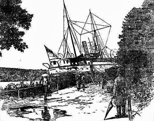
Bill Dennison · | Queensland Floods |You can take a walk down the street to the Botanic Gardens; you can find a little park there; the Paluma Park. And that's to commemorate the location where a large gunship washed up into the Botanic Gardens in February, 1893. Interesting story, the Paluma was a gunship that was commissioned by the Queensland government. There were two gunships, the Gayundah and the Paluma, which were built because of the Russians. They also built Fort Lytton down at the mouth of the river in the 1800’s. Paluma was down from Townsville, where she was being used to do some survey work, and getting a refit in Brisbane, and the steam boiler was shut down. So, the flood came, and it couldn’t navigate. Most of the other ships were able to go out and anchor in the river. The Paluma got washed up into the Botanic Gardens, and they were saying, “What are we going to do? How are we going to recover this ship? We could build a railway or dig a canal.” Sir Samuel Griffin and other politicians were dithering over this as some politicians do (sorry to those in the audience). Luckily, they waited until two weeks later, because another flood came within five feet of the first flood, and a tugboat, over a twenty four hour period was eventually able to rock back and forth and drag the Paluma into the river, until they got it re-floated, virtually for free.

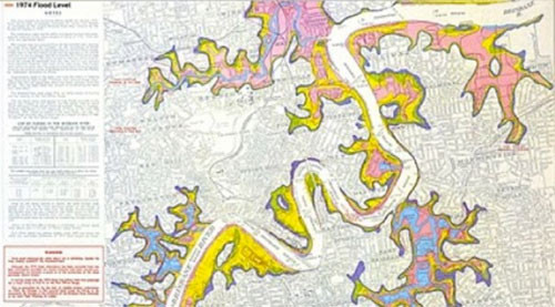
Here is the ‘74 flood map and, of course, when you’re in the real estate business, you don’t want to share this if your trying to flog a house on the riverbank, but it does show some of the areas where we probably should be re-thinking how we build, and what we build. The 1974 flood was in recent memory.

So it's kind of a shame that we’ve built some of the infrastructure we have since ’74, and had as many houses damaged as we did. Now, Brisbane City Council has responded pretty proactively with an online map available. I am proud to say that I am living in Highgate Hill, which is high enough up. I got this pamphlet in the mail the other day about this online mapping tool. I went and had a look, and it looked pretty accurate, so, this is a good tool. Too bad we didn’t have this before the flood.
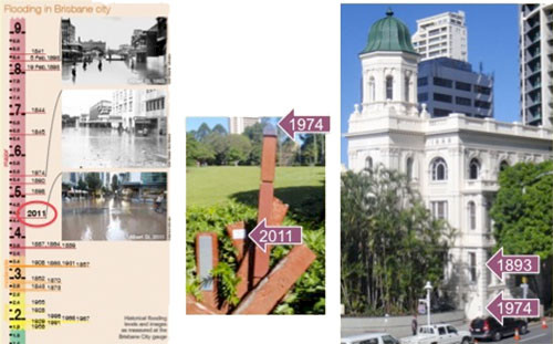
Kate Moore helped me go back and look through the flood record. Here are three photos of Albert Street in 1893, 1974, and 2011, underwater all three times. You can see that 2011 is only the ninth largest flood since 1840. There is 1841, the two floods I mentioned with the Paluma, in February 1893, and 1844, the 1840, 1974, and 1890.

You can see one thing that’s important. That is that it’s grouped. It’s not a thirty-year cycle. There are groupings. This has to do with the El Niño/La Niña cycle of weather and sea-level. So what you see here in the Botanic Gardens is the ’74 flood marker, and you can see it’s about a meter below the 2011 marker. Near the Customs House on Eagle Street is the Naldham Building, which has these little brass plaques that are on the wall, and you can see the 1893 marker right here. In 2011, your feet were barely wet. So as bad as we had it in January, as devastating as that flood was; can you imagine? Can you appreciate what devastation we would have had if this was anywhere near the 1893 level, for example?
This blog post was created from a presentation by Bill Dennison, delivered at the historic Customs House in Brisbane, Australia on 8 July, 2011 (full powerpoint presentation can be accessed on IAN Press.
About the author
Bill Dennison

Dr. Bill Dennison is a Professor of Marine Science and Vice President for Science Application at the University of Maryland Center for Environmental Science.