Brisbane 2011: Living with Floods and Dancing with Dugongs: Part 2- A Learning Moment
Bill Dennison ·We really did have a learning moment. This is needed regarding the flooding and the impact of the flooding. We had two kinds of floods. We had the flash flooding that occurred up the Lockyer, and we had the riverine flooding that occurred in Ipswich and in Brisbane. The flash flooding, which is water coming down, was intense rainfall. We had two hundred millimeters in one hour, substantial amounts of rainfall leading to the rapid rise of water. In one place it rose eight meters in one hour leading to high energy and destructive forces: twenty people died, unfortunately. The flash flooding was concentrated in the upper reaches of the Lockyer Creek. Impacts other than lives lost included livestock lost (except that one cow that made it alive ninety kilometers down the river into Moreton Bay). Crops and paddocks were destroyed. Infrastructure was destroyed including houses, roads, bridges, outbuildings, fences, and equipment. Debris was accumulating in the streams and rivers and widespread damage to street banks and vegetation occurred. So this was one kind of flooding.

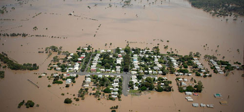
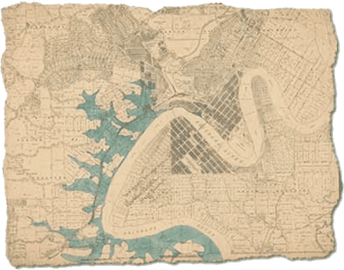
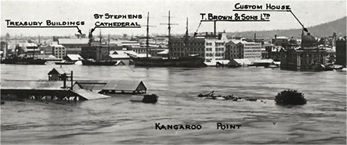
And then there was the more gradual, slow rise of water that occurred over the next couple days in Ipswich and Brisbane due to the prolonged rainfall. The riverine flooding created a tremendous loss of infrastructure, widespread flooding throughout the flood plain in Brisbane, lapping up here at Customs House, leading to widespread building damage. Most of you must have been here or near this. It was like a cataclysmic event. There was full time media coverage. Oddly, there was a tremendous amount of surprise to most people. It should not have been a surprise. This happens in this part of the world. Drought punctuated by extreme events is what Queensland is about. The flood was quite predictable. This is the 1893 flood map. So, in 1893 you can track the areas of Brisbane that were flooded. So, this shouldn’t have been a big surprise. Even photographic evidence: You can see Kangaroo Point, in 1893, you can see where we are today, in the Customs House. You can see the water in the basement during 1893. It didn’t make it up here until 2011, but you can see a few other landmarks, and it was before the Story Bridge, but you can see how much of the system was affected.


This blog post was created from a presentation by Bill Dennison, delivered at the historic Customs House in Brisbane, Australia on 8 July, 2011 (full powerpoint presentation is available on IAN Press.
About the author
Bill Dennison

Dr. Bill Dennison is a Professor of Marine Science and Vice President for Science Application at the University of Maryland Center for Environmental Science.

