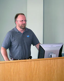
Discussion following Howard Townsend's seminar on Communicating complex scientific results for ecosystem-based management using cgi (computer generated image) animation
Bill Dennison · | Learning Science |
This blog post discusses the seminar given by Howard Townsend, of the NOAA Chesapeake Bay Office, at the IAN Seminar Series on June 24, 2010.
Following Howard's seminar, two short videos were aired. The first one depicted some of Howard's hidden talents on the dance floor, and the second one was a 6 minute Computer Generated Image (CGI) film entitled "Life in the Chesapeake Bay", produced by NOAA in conjunction with Lenfest Ocean Program and the University of British Columbia. This film was created with fisheries scientists at the University of British Columbia working with graduate students in Visual Media. The film provides an overview of the major fisheries issues in Chesapeake Bay, starting with the historical oyster over-harvesting. The underwater vistas, including oyster reefs, submerged aquatic vegetation meadows and schools of fish, were remarkable. A major issue, the so-called 'dead zone', is depicted as a cloudy and bleak seascape. Blue crabs scuttling across the bottom and massive schools of menhaden are also depicted. The food web model is introduced, but only in general terms. The vision for what Chesapeake Bay could be, including teeming life, including sea turtles, sturgeon and whales provided a nice ending note.
One of the questions raised was if the fisheries models (Ecopath with Ecosim) could account for fish migrating into and out of Chesapeake Bay. Howard indicated that the Ecosim model uses a 'vulnerability parameter', which takes into account migration. Another question was about the lack of jellyfish in the visualization. Howard indicated that jellyfish were indeed in the model, but the lack of a good artistic rendering prevented them from appearing in the CGI. The issue of sublethal oxygen stress was raised, with the potential concentrating of prey items which could influence predation rates. Howard was asked about the indicators that appear on the top of the screen of the model visualizations which included an economics figure and a jobs figure. He indicated that these were just nominal values for demonstration purposes, but each of these indices would be rolling up a suite of separate indicators which could be obtained through a drill-down function.
Howard spoke about some other efforts worldwide to produce these integrated fisheries models and visuals and indicated that in Australia, the Atlantis model made by CSIRO (Commonwealth Science and Industry Research Organization) has been rated as one of the best.
An issue that the fisheries models are going to need to address is the predictions for fish populations with reduced sediment and nutrient inputs into the Bay as the Total Daily Maximum Loads and other management efforts work to reduce inputs. The alternatives are a) more nutrients = more food = more fish or, conversely, b) reduced nutrients increase water clarity, allow more habitat like submerged aquatic vegetation and results in more blue crabs. The scenarios that can be run with a good ecosystem level model would help resolve this conundrum.
The current modeling effort focuses on the Bay as a whole, and future iterations could include a spatial element. Having two screens with a map and cross section would be useful in understanding fisheries responses, and the report card region level of segmenting the Bay (15 reporting regions) would likely be the finest spatial detail possible with the data available. The concept of focusing on the connection between nutrient loads (particularly nitrogen) and submerged aquatic vegetation was discussed, based on a recent analysis by a group of scientists led by Bob Orth, Virginia Institute of Marine Science, in a paper that is in press in the scientific journal Coasts and Estuaries. In addition, the relationship between blue crabs and submerged aquatic vegetation has also been studied, which could lead to a connection between nutrients (water quality), submerged aquatic vegetation (habitat), and blue crabs (living resources), thus linking the major elements of the Chesapeake Bay Program.
One of the visions for future CGI versions is to be able to drive around in an underwater vehicle, and perhaps actually manipulate a robotic arm to pick up objects. The underwater vehicle track could be mapped in an accompanying nautical chart. Another tack could be developing a game function using the model and visualizations; sort of a SimChesapeake, like the SimCity game. In this way, fisheries managers could investigate different options.
About the author
Bill Dennison

Dr. Bill Dennison is a Professor of Marine Science and Vice President for Science Application at the University of Maryland Center for Environmental Science.