Does rising sea level signal the end for LUMCON, or a beginning?
Bill Nuttle · | Environmental Report Cards |On December 10, I traveled to Cocodrie, Louisiana, to visit Dr. Nancy Rabalais. Nancy is the Director of the Louisiana Universities Marine Consortium (LUMCON), and she has done more than anyone else to draw attention to hypoxia in the Gulf of Mexico. Nutrients in runoff from the Mississippi watershed trigger low-oxygen conditions in the shallow coastal waters of the Gulf, just as they do in many estuaries around the world including the Chesapeake Bay. The purpose of my visit was to get Nancy’s recommendation on what indicators we should include in the new Mississippi watershed report card so that we can track the success of efforts to reduce the hypoxic zone. On my drive to and from Cocodrie I was able to see how people cope with the challenges of living so close to sea level along this low-lying coast.

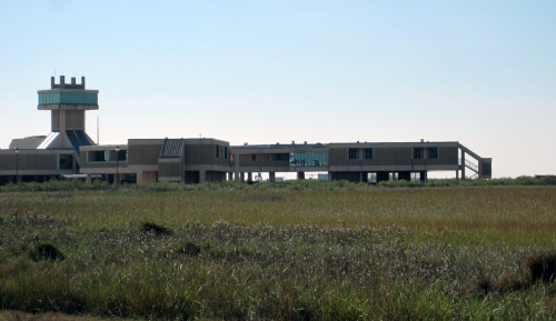
This was my first visit to the LUMCON facility. The W. J. DeFelice Marine Center would not be out of place on any university campus, but it makes a striking appearance hovering above the wetlands surrounding Cocodrie. Like every other structure in Cocodrie, the center is raised above the ground on columns to protect against flooding from coastal storms. LUMCON was formed in 1979 to support coastal research and education and to raise public awareness of the value of Louisiana’s coastal region. About 60 people work here. Its location in Cocodrie provides excellent access for research vessels to the productive waters of the Louisiana coast and the Gulf of Mexico. The center houses a number of laboratories with running estuarine and sea water, a taxonomic reference collection, and facilities to host visits by school groups and long-term visitors.
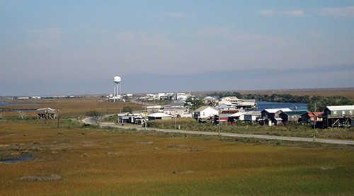
You get to Cocodrie by driving through Houma. On my map of coastal Louisiana, Houma looks like the body of a jellyfish with tendrils streaming down beneath it toward the Gulf of Mexico. The tendrils are areas of high ground that trace out the paths of the bayous Dularge, Grand Caillou, and Little Caillou. Civilization clusters on the high ground built by these former freshwater distributaries of the Mississippi River. Near Houma the area between the bayous is filled in with low lands, freshwater swamps and marshes. Further south, this area is filled with coastal salt marsh and, increasingly, open water. Across the entire distance of maybe 40 miles between Houma and the Gulf of Mexico, the landscape is unimaginably flat, and the vertical relief of the high ground along the bayous is hardly more than that of a jellyfish stranded on a beach.
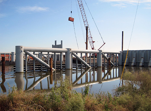
From Houma, I drove south on Grand Caillou Road, state Route 57, through the towns of Boudreaux and Dulac. The road between Boudreaux and Dulac is lined with single houses, sometimes with a shrimp boat tied up behind along the bayou. South of Dulac, Route 57 follows Bayou Sale further south, past the last house, and then cuts east through the marsh to intersect Route 56, which follows Bayou Little Caillou from Houma until it ends at Cocodrie. Turning south, I drove about a half a mile and encountered a huge steel structure under construction across the bayou. Curious, I stopped to take a closer look and got into conversation with the project engineer.

The structure is part of the Morganza to the Gulf project [pdf], a 98 mile earthen levee supposed to be a barrier to the tidal surge generated by coastal storms and to salt water driven by sea level rise that threatens freshwater supplies. This is one of 22 gates planned for navigable waterways that cross through the levee. The gates will be open most of the time to allow the free flow of water and boat traffic, and they will be closed in advance of a severe storm or hurricane. The gate and levee are being constructed to an elevation of about +10 feet in the first phase of construction of the Morganza to the Gulf project, which is being paid for by a local sales tax. The area protected by the project includes Houma, Boudreaux and Dulac north of the levee. Cocodrie and LUMCON are outside of the levee, 4 and half miles further south.
Following our discussion of hypoxia indicators for the report card, I got to ask Nancy Rabalais the question that I was really interested in: “Are you planning for the day that rising sea level will force LUNCON to close the marine center and leave Cocodrie?” Coastal Louisiana has the highest rate of relative sea level rise in the US. This is the result of rapid subsidence of the region’s deltaic sediments added on top of an accelerating rate the rate of global sea level rise. Next door, in Lafourche Parish, the town of Leeville already is disappearing beneath rising waters. Geologists at Louisiana State University have projected what the coast of Louisiana would look like with 1 meter (3.3 feet) of sea level rise [pdf]. Cocodrie will be gone, replaced by open water. According to projections, this could happen in 50 years.

Nancy replied that she has worked here for 30 years, and she expects that LUMCON will remain where it is for at least another 30 years. The building is well-designed. The foundation sits on steel piles driven 120 feet into the ground, and the first floor is raised 18 feet above the ground. This puts it above level of storm surge that will overtop the levee and floodgates being built for the Morganza to the Gulf project. That’s not to say that the center is immune to changes affecting the coast around it. Nancy pointed out her window to where a 6-inch gap has opened between a concrete pad attached to the building and the subsiding ground beneath it. Nuisance flooding by extreme high tides is causing more problems – the center had to close in July 2010 when high water, not related to any storm, flooded the parking lot. Nancy took me on a tour of the building, which ended up at “Hurricane Alley,” a stairwell descending to ground level. The walls were lined with poster displays for visitor describing the effects of recent hurricanes – the eye of Hurricane Rita made landfall at Cocodrie. Painted on the wall at the bottom of the stairwell are the high water marks due to storm surge high water marks from Hurricanes Katrina (2005), Rita (2005), and Gustave (2008).
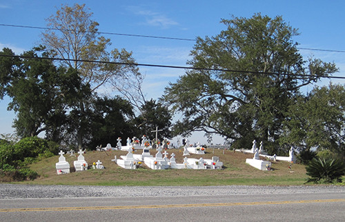
On the drive back from my visit to LUMCON I traveled along the tentacle of land the surrounds Bayou Little Caillou. This route took me through the town of Chauvin and past the Picou Cemetery, a local landmark. The cemetery is easy to spot because its whitewashed tombs rise 7 feet above the road on an old Indian mound. This is one of 5 mounds built here by people who lived in coastal Louisiana 1000 years ago. Mounds like these are found throughout Louisiana and north along the Mississippi River valley. Exactly why people built the mounds in Chauvin is not known. This might have been a sacred site, as it is now. Or, it might have been a fishing camp. No matter, in all likelihood these mounds were the highest points of land for a distance of perhaps 10 or 15 miles; therefore they would have provided refuge from flooding, either from coastal storms or from the Mississippi River.

In the end, I have come to share Nancy’s optimism about the long-term future for LUMCON in Cocodrie. People are attracted to the coast by the resources and amenities it offers, and they have adapted ways of coping with its dynamic nature for at least 1000 years. The LUMCON marine center has a special role to play in helping sustain this relationship. The new challenges posed by rising sea level expand this role. As a center for coastal research, it is a sensor of the changes occurring in the coastal ecosystem. But it is also a community of people living and working at the exposed tip of a tentacle of civilization, coping with a dynamic, environment now undergoing rapid, sustained change due to rising sea level, and with a mission to raise awareness of the coast and its importance.