Environmental literacy of the Texas coastline
Bill Dennison · | Environmental Literacy |As part of a workshop sponsored by the Harte Research Institute, Texas A&M University in Corpus Christi, we learned about the key values and major threats to the Texas coastal ecosystems. We did not include the offshore continental shelf in this assessment, so some iconic features like the flower garden coral reefs were not included. The environmental literacy principles for the Texas coast are the following:
- The Texas coast is dominated by microtidal embayments, sandy barrier islands, and shallow lagoons that are poorly to well flushed depending on freshwater flows.
- There is a strong north to south gradient along the Texas coast in precipitation/evaporation and temperature resulting to gradients in relative abundance of seagrass, salt marsh and mangrove habitats.
- Texas lagoons and embayments are affected by hurricanes, nutrient loading, harmful algal blooms (e.g., brown tide) and hypersalinty.
- There are significant fisheries, oyster and serpulid worm reefs, resident and migratory birds in Texas coastal lagoons and embayments (aka "Nature's Playground").
- Climate change effects are manifested along the Texas coast with relative sea level rise leading to inundation and temperature changes leading to salt marshes transitioning to mangroves.
- Residential development on barrier islands and industrial development on the mainland impact natural resources for the Texas coast.
- The busy Texas portion of the Gulf Intracoastal Waterway is maintained by dredging including engineered passes to the Gulf of Mexico.
7 Environmental Literacy of the Texas Coast
1. The Texas coast is dominated by microtidal embayments, sandy barrier islands and shallow lagoons that are poorly to well flushed depending on freshwater flows.
The Texas coast extends 700 km (423 miles) with state of Louisiana to the north and the country of Mexico to the south. The Texas coast is subtropical, extending from roughly 30ºN to 26°N. The Texas coast is oriented Northeast/Southwest above Corpus Christi and North/South below Corpus Christi. The dominant coastal feature is an elongated sandy barrier island system with coastal lagoons and embayments behind the barrier islands. The western Gulf of Mexico is microtidal with small daily tidal excursions (<0.5 m; <1.5'), but there are seasonal periods of higher and lower water levels as well as periodic meteorological tides caused by large atmospheric pressure differentials. The lack of appreciable tides means that freshwater flow is particularly important in establishing the flushing time of the embayments and coastal lagoons. In some embayments there is appreciable freshwater flushing (e.g., Sabine River), but some of the lagoons there is minimal flushing (e.g., Upper Laguna Madre). Flushing time in Laguna Madre is on the order of months to years.
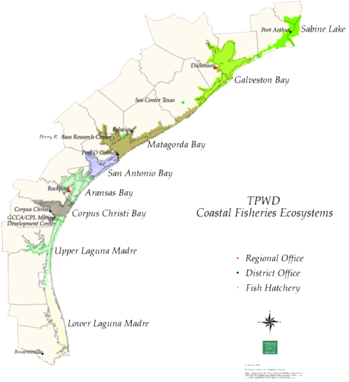
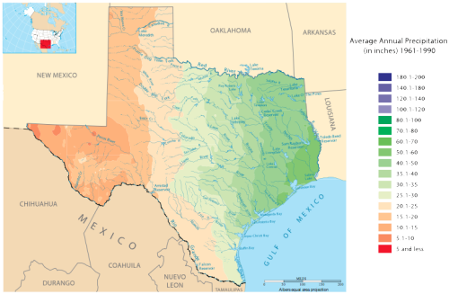
2. There is a strong north or south gradient along the Texas coast in precipitation/evaporation and temperature, resulting in gradients in relative abundances of seagrass, salt marsh and mangrove habitats.
There is a pronounced gradient in the balance between precipitation and evaporation along the Texas coast. This hydrological gradient in turn leads to gradients in various other features. To the north of Corpus Christi, precipitation exceeds evaporation and to the south of Corpus Christi evaporation exceeds precipitation. This gradient leads to changes in salinity within the embayments and coastal lagoons, with estuarine conditions north of Corpus Christi and hypersalinity conditions common south of Corpus Christi. In addition, there is a temperature gradient, with higher temperatures to the south. The temperature gradient enhances the growth of tropical species (e.g., mangroves and tropical seagrasses) in the southern portion of the Texas coast and the growth of temperate species (e.g., salt marshes and temperate seagrasses) in the northern portion of the Texas coast.
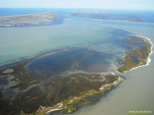
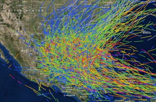
3. Texas lagoons and embayments are affected by hurricanes, nutrient loading, harmful algal blooms ("brown tide") and hypersalinity.
The Texas coast is regularly impacted by tropical cyclonic storms, often with hurricane force winds, storm surges and intense rainfall leading to flooding. The 1900 Galveston hurricane led to a massive loss of life (over 8,000 deaths) due to a massive storm surge that swept over the barrier island where Galveston is located. Hurricane Ike also struck Galveston in 2008 and caused over 100 deaths. Hurricane Rita in 2005 and Tropical Storm Allison in 2001 led to major flooding. The embayments and lagoons are affected by sediment mobilization and erosion, coastal inundation, and large salinity excursions. Nutrient loading via a) direct discharge of sewage wastewater effluent occurs near locations of residential developments, via b) indirect inputs due to runoff from stormwater, agriculture and shrimp ponds in the watershed, and c) via atmospheric deposition. These nutrient inputs lead to microalgal and macroalgae blooms in the coastal waterways. A particularly persistent and harmful algal bloom centered in Baffin Bay and Upper Laguna Madre is the "Brown Tide". Blooms of the chrysophyte Aureoumbra lagunensis began in 1989 and continue to reoccur, with deleterious ecological impacts on the flora and fauna of the embayments and lagoons. The combination of the microtidal regime with the net evaporation south of Corpus Christi leads to hypersalinity conditions, which are particularly acute in Upper Laguna Madre. Salinities as high as 70 ppm have deleterious impacts on flora and fauna.

4. There are significant fisheries, oyster and serpulid worm reefs, resident and migratory birds in Texas coastal lagoons and embayments (aka "Nature's Playground").
Recreational fishing is popular throughout the coastal embayments and lagoons. Galveston Bay, close to Houston and Galveston population centers, supports a large fishery, particularly for redfish, specks and flounder. Fishing in Laguna Madre for spotted sea-trout, red drum and black drum occurs. Shrimp are found throughout the Texas coast. Offshore commercial fishing boats are moored in harbors within the coastal waterways as well. The oyster reefs in the estuarine portions of the northern coastal embayments were common, but have been reduced due to sedimentation and other factors. There are some very unique serpulid worm reefs formed by tube dwelling polychaete worms in high salinity Baffin Bay that can be 2 m (6') above the bottom. The Texas coast is a major North American flyway for migratory birds as part of the central flyway. The Texas coastal waterways provide breeding and wintering habitat for shore birds, marsh birds, forest birds and waterfowl. Internationally significant populations of birds use coastal habitats of Texas including Brown Pelican, American Flamingo, Redhead, Whooping Crane, Sooty Tern, and Snowy Plover. Laguna Madre supports over 70% of the overwintering population of Redhead. Some bird species populations, like the Brown Pelican, are recovering from previous population declines.

5. Climate change effects are manifested along the Texas coast with relative sea level rise leading to inundation and temperature changes leading to salt marshes transitioning to mangroves.
Like many coastlines around the world, the Texas coastline is vulnerable to the effects of climate change in a variety of ways. Relative sea level rise, which is the combination of rate of land subsidence, and the rise in sea level is high along the Texas coastline. Rates as high as 6.0 mm per year have been observed. These high rates of relative sea level rise lead to inundation of low-lying coastal land and can cause habitat shifts, accelerate coastal erosion and lead to barrier island migration and breaches during storm surges. The temperature increases, particularly during winter, lead to extended survival of tropical species. An example of this thermal effect is the expansion of mangroves at the expense of salt marshes. Climate change impacts include more frequent and severe storms, so the frequency and intensity of hurricanes and tropical storms may increase along the Texas coast. Many tropical species are posed near their thermal limit so climate change related temperature extremes in the summer could affect various species.
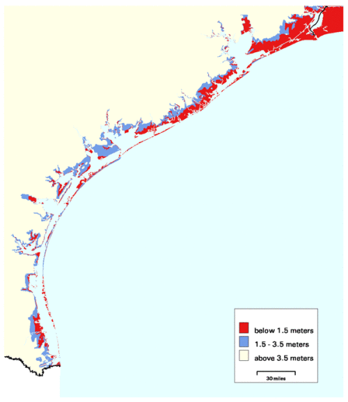
6. Residential development on barrier islands and industrial development on the mainland impact natural resources for the Texas coast.
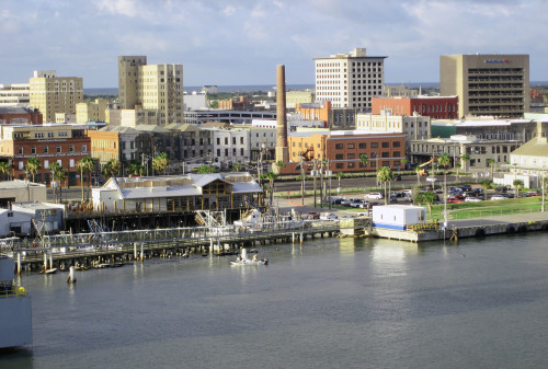
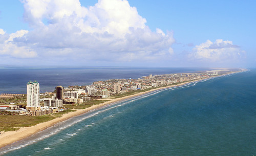
The Texas coast supports major cities (e.g., Houston, Corpus Christi, Galveston) which are growing, In addition, there is significant residential development in small towns and cities along the embayments and coastal lagoons barrier islands (e.g., South Padre Island) which increases shoreline hardening, nutrient inputs via septic systems, wastewater treatment effluent, lawn fertilizers, and intensified recreational activities. There is major industrial development on the mainland adjoining the embayments and lagoons of Texas. Oil refineries, chemical plants and port facilities have been constructed on low-lying coastal land. There are several active ports in Texas, especially Houston, but also including Port Arthur, Beaumont, Texas City and Corpus Christi. These industrial activities contribute to stormwater runoff, potential chemical contamination and increased shipping activity.
7. The busy Texas portion of the Gulf Intracoastal Waterway is maintained by dredging including engineered passes to the Gulf of Mexico.
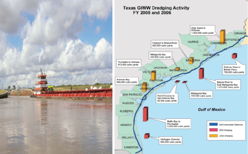
The Texas portion of the Gulf Intracoastal Waterway (GIWW) is 680 km (423 miles) long; a major part of the entire Gulf Intracoastal Waterway, which is 1700 km (1050 miles) long, extending from the Texas/Mexico border to the panhandle of Florida. The GIWW was completed in 1949. Maintenance dredging of the GIWW is required to maintain the GIWW controlling depth for shipping which is 3 m (9'). There are 16-17 inlets or passes through the barrier islands. The Texas passes are armored with jetties and are actively maintained by dredging for navigation. The Texas portion of the GIWW is quite busy and accounts for 58% of the total traffic of the GIWW. The port of Houston is one of the busiest ports in North America and ranks among the largest in the world.
About the author
Bill Dennison

Dr. Bill Dennison is a Professor of Marine Science and Vice President for Science Application at the University of Maryland Center for Environmental Science.