Ohio River basin: Environmental Literacy
Bill Dennison ·'Environmental literacy' series
The seven environmental literacy principles for the Ohio River basin are the following:
- The Ohio River is the major eastern tributary of the Mississippi River, traversing through a diversity of landscapes.
- The Ohio River is the major water source of the Mississippi River, with its flow regulated through a series of locks and dams.
- The Ohio River basin is resource-rich, with fertile agricultural soils, coal and gas resources, water and energy intensive industries, and supports 10% of the U.S. population.
- There are many significant tributaries to the Ohio River including the Tennessee, Cumberland, Kentucky, Wabash, Great Miami, Allegheny, and Monongahela Rivers.
- The Ohio River has been important in the history of the United States, particularly as a transportation corridor (connecting to the Great Lakes and the Gulf of Mexico).
- There are significant threats to the Ohio River, and it has been rated a highly polluted river due to excess nutrients, contaminants and invasive species.
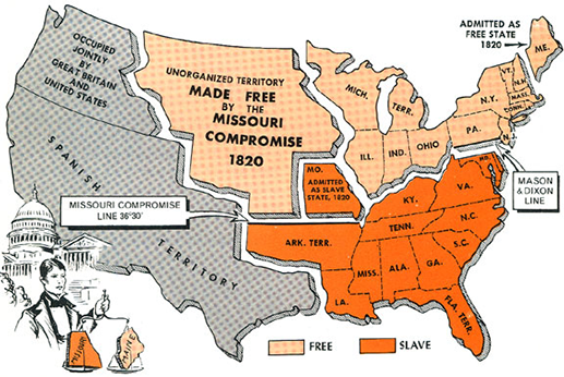
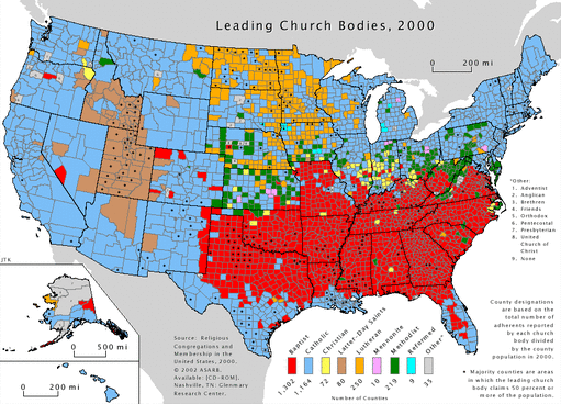
- The Ohio River forms an important cultural north/south boundary representing the division between the free states vs. slave states, Catholic/Methodist vs. Southern Baptist, respectively.
1. The Ohio River is the major eastern tributary of the Mississippi River, traversing through a diversity of landscapes.
The Ohio River joins the Mississippi River at Cairo, Illinois and has its origin nearly 1000 miles away in the Appalachian Mountains. The Ohio River traverses the Great Plains, continental glacier landscapes including glacial moraines, the foothills and mountains of the Appalachian Mountains, and the Tennessee River valley. There are eleven states with land in the Ohio River basin.
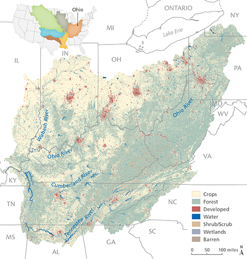
2. The Ohio River is the major water source of the Mississippi River, with its flow regulated through a series of locks and dams.
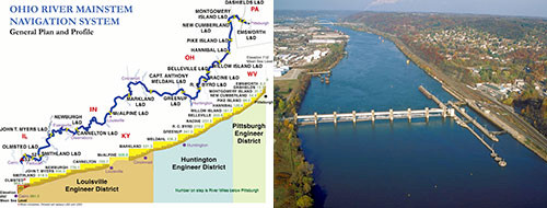
The prevailing westerly wind patterns intersecting the Appalachian Mountain range lead to the adiabatic rise of air masses, cooling and precipitation on the west side of the Appalachian Mountain range. This precipitation leads to runoff in the headwaters of the Ohio and Tennessee Rivers and high water flows. When the Ohio River enters the Mississippi River, the volume of water from the Ohio River is greater than the volume of the Mississippi River. The water flow in the Ohio River mainstem is highly regulated all the way up to Pittsburgh via a series of locks and dams, maintained for navigation purposes as well as flood control. The Tennessee River has a series of dams used for hydroelectric power generation as well as flood control.
3. The Ohio River basin is resource-rich, with fertile agricultural soils, coal and gas resources, water and energy intensive industries, and supports 10% of the U.S. population.
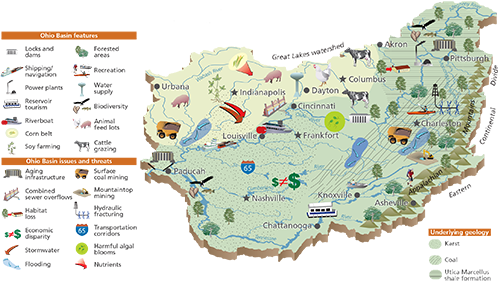
The Ohio River basin has productive agricultural land within the 'corn belt' which is largely grown as animal feed. Rotations of other crops are common, for example, soybean crops are rotated into production, interspersing with corn crops in order for the soybeans to fix nitrogen and enhance soil fertility. The coal industry has long been active in the Ohio basin, and an emerging industry uses hydraulic fracturing ("fracking") to obtain natural gas. The reliable, abundant water supply has attracted heavy, water-intensive industries, like the steel industry in Pittsburgh, Pennsylvannia or the soap industry in a Cincinnati, Ohio. The Ohio basin has been an attractive place to live and work, and it now contains over 10% of the entire U.S. population.
4. There are many significant tributaries to the Ohio River including the Tennessee, Cumberland, Kentucky, Wabash, Great Miami, Allegheny, and Monongahela Rivers.
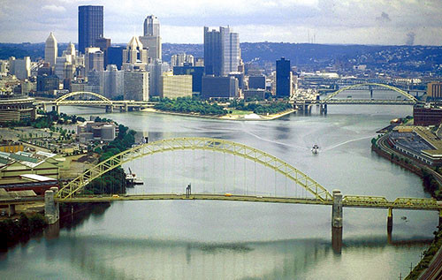
The Ohio River has a multitude of large perennial streams and rivers that flow into it throughout its long journey (981 miles long). The Ohio River is formed from the confluence of the Allegheny and Monongahela Rivers in Pittsburgh. The Tennessee River is the largest tributary (652 miles long) of the Ohio River. Significant tributaries to the south of the Ohio River include the Cumberland and Kentucky Rivers and significant tributaries to the north of the Ohio River include the Great Miami and Wabash Rivers.
5. The Ohio River has been important in the history of the United States, particularly as a transportation corridor (connecting to the Great Lakes and the Gulf of Mexico).
The Ohio River basin was the destination for many early colonists with its dense forests and abundant fish and game. The ability of the Ohio River to connect the Gulf of Mexico via the Mississippi River with the Great Lakes via various canals made the river a particularly important transportation corridor. Various significant transportation schemes have focused on connecting the Ohio River to other regions, like the Baltimore & Ohio Railroad and the Chesapeake & Ohio Canal system which provided connectivity to the east coast.
6. There are significant threats to the Ohio River, and it has been rated a highly polluted river due to excess nutrients, contaminants and invasive species.
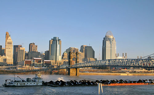
The Ohio River is highly polluted due in part to the considerable industrial development along the river banks and in the watershed and the extensive intensive agriculture in the watershed. The Ohio River drains coal mining regions and will be increasing affected by hydraulic fracturing runoff. Another reason for Ohio River pollution is the lack of effective flushing due to the extensive lock and dam infrastructure for navigation that increases the residence time of water, allowing pollutants to accumulate. The extensive shipping through the Ohio River also promotes the introduction of invasive species.

7. The Ohio River forms an important cultural north/south boundary representing the division between the free states vs. slave states, Catholic/Methodist vs. Southern Baptist, respectively.
The long east-west orientation of the Ohio River serves as an important cultural boundary. Some of the states to the north of the Ohio River (Ohio, Indiana, Illinois, Michigan, Wisconsin and parts of Minnesota) were known as the Northwest Territory from 1787-1803 before becoming states. Up until the American Civil War, the Ohio River was a boundary for free states north of the river and slave states to the south. The National Underground Railroad Freedom Center in Cincinnati, Ohio serves as a reminder of the legacy of slavery. Religion is also strongly divided north and south of the Ohio River, with Southern Baptist dominating to the south and Catholic, Methodist, and Christian dominating to the north.
About the author
Bill Dennison

Dr. Bill Dennison is a Professor of Marine Science and Vice President for Science Application at the University of Maryland Center for Environmental Science.

