South East Queensland 2011 flood newsletter
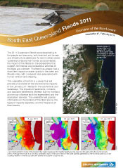
Bill Dennison · | Queensland Floods |A 2011 Flood Science Taskforce was convened on 20 January 2011 to coordinate flood monitoring efforts and to discuss potential environmental impacts in the catchment and the waterways, including Moreton Bay. At the task force meeting, aerial and satellite images were displayed, the hydrodynamic model was run and available data were presented. A conceptual diagram of rural and urban catchment impacts and Moreton Bay impacts was sketched at the meeting, and further developed with Healthy Waterways and Queensland Department of Environment and Resource Management staff. The newsletter was developed with Healthy Waterways staff and utilizes a modified version of the conceptual diagram, examples from the hydrodynamic model runs, and various photographs from airplanes, satellites, and historical archives.
This science newsletter is first in a series of updates regarding the 2011 flood and represents an important step in capitalizing on a societal learning moment. One of the key elements of the newsletter is the attempt to put the 2011 flood into historical context. The 2011 flood is only the ninth largest on record in Brisbane (since 1840), yet was particularly devastating due to the large amount of infrastructure that was damaged. Previous floods destroyed the bridges that spanned Brisbane River and also flooded thousands of homes, but the 2011 flood damage will undoubtedly be the most costly ever.
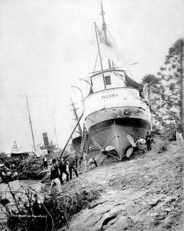
A historical photo of a navy gunboat, HMAS Paluma, perched high and dry in the middle of the Botanical Gardens in the central business district of Brisbane is particularly poignant. It serves to demonstrate the magnitude of the floods and since the photograph is from 1893, it demonstrates that this is a regular occurrence for the Brisbane River. As an interesting footnote to the story of the Paluma is that a contract was tendered for relocating the ship back into the Brisbane River, but instead of having to dig a canal or build a railway, a second flood two weeks later refloated the boat, and it was returned to the river undamaged. It was fitting that a modern naval hydrographic survey ship named HMAS Paluma was deployed to Moreton Bay in 2011 to join the HMAS Shepparton and HMAS Huon to help clear the Brisbane River and Moreton Bay shipping channels.

The concept of '1 in 100 year' flood levels is likely not a good term to describe the frequency of inundation, particularly in Brisbane. What a '1 in 100 years' probability really refers is the 1% annual exceedance probability, that is to say that each and every year, there is a 1% chance of a flood of a particular level. A 100-year flood has a 63% chance of occurring in any particular 100-year period. To have two floods in one year (e.g., 1893) is possible, as well. The 9 major floods that have occurred in Brisbane in the past 170 years, as depicted in the newsletter, demonstrates that major floods occur at a much more frequent period than 1 in 100 years.
About the author
Bill Dennison

Dr. Bill Dennison is a Professor of Marine Science and Vice President for Science Application at the University of Maryland Center for Environmental Science.
