Tackling watershed size: A collaborative effort - difficulties of science in management due to watershed size
Cara Schweitzer, Rebecca Peters, Fan Zhang ·Cara Schweitzer, Rebecca Peters, Fan Zhang
Watershed size can be very important in the determination and implementation of environmental monitoring and management strategies of coastal systems.

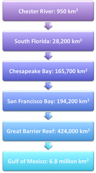
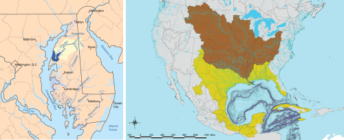
A watershed was defined by John Wesley Powell, geologist and director of the USGS (1881-1894), as "that area of land, a bounded hydrologic system, within which all living things are inextricably linked by their common water course and where, as humans settled, simple logic demanded that they become part of a community.” and proposed to congress that states should be divided by watershed. This however was thrown out by congress and currently watersheds can span anywhere from a single state to several states; for example, Maryland’s Chester River watershed spans less than 1,000 km2 (Fig 2); in comparison with the watershed of the Mississippi, which feeds into The Gulf of Mexico, is composed of 31 states stretching over 3 million km2. Additionally, watersheds of both Mexico and Cuba and even southern parts of Canada affect the Gulf of Mexico’s water quality. This massive watershed spanning 31 states and 4 countries introduce complexities of which need to be addressed when planning mentoring and management actions (Fig 2).
It is important to keep watershed size into consideration for scientific monitoring. Land use within the watershed area can account for much of the variability of water quality (O’Neill et al., 1997). Additionally, watershed land can often be used as a predictor of biologic indicators within streams (Wang, 2001; King et al., 2005), which can be important when developing management policies of land use (Hall et al, 1994). Over half of the Chester River watershed is occupied by agriculture and as a result high levels of nitrogen and phosphorus were being recorded within the Chester River. The Chester River Association promoted the use of cover crops (kale, wheat, rye, etc.), planting switchgrass and repairing old and failing septic systems to reduce nutrient concentrations. On the other hand, the Gulf of Mexico has multiple management programs. One program is The Gulf of Mexico Alliance (GOMA); this alliance brings together federal and state governments, academic, non-government organizations, and private partners – members of the USA and Mexico, however this alliance is a collaboration of only 5 states when water quality is effected by land use of an additional 26 states as well as Canada and Cuba. Being the fourth largest watershed in the world, it may be nearly impossible to bring all contributing states and countries together.

This increase in size gradient increases the amount of variables effecting water quality and obstacles in relation to scientific monitoring and management due to encompassing multiple jurisdictional boundaries. Larger size gradients pose complexities within scientific community with regards to monitoring; becoming increasingly more difficult for scientists to monitor larger areas, such as Chesapeake Bay, San Francisco Bay, and the Great Barrier Reef. In many instances several scientists associated with multiple universities will study sections within a large ecosystem. During such instances it is beneficial for scientists to participate in collaborations to solve more complex turbid issues (Selin and Chavez, 1995). Collaborations can ensure consistency among methodological approaches in data collection and analysis. This is beneficial in the big picture aspect, which allows for a broader range of data to be incorporated into ecological modeling; this may aid in management policy formulation. However, scientific collaboration alone is insufficient to produce robust environmental change. Scientist must combine their knowledge from data collection with local knowledge; this combination may empower locals and inspire them to monitor and manage environmental change easily and accurately (Reed and Dougill, 2010). Reed (2008) hypothesized that by combining scientific “know-why” and local “know-how” knowledge communities could produce a more effective environmental policy and practice.
However, collaborative attempts between scientists and/or government can at times be more easily said than done. Conflicts at times can arise for several reasons: collaborative partner(s) lacking in flexibility in implementing agreements and decision-making, compromise can be seen as ‘watering down’ the original mission or goal, and relationship factors between colleagues having opposing views (Selin and Chavez 1995).
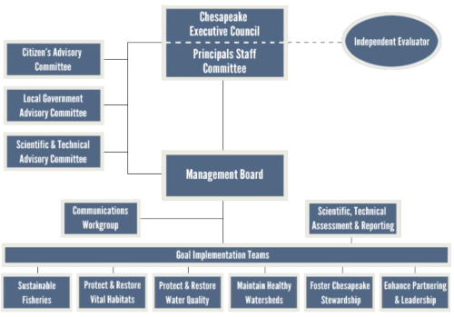
In size based management programs of environmental sustainability, two marine areas are viewed as icons; seemingly to have a higher management success rate compared to others: The Chesapeake Bay and The Great Barrier Reef. The Chesapeake Bay is 4,479 mi2 with a watershed area of 64,000 mi2 bordered by Maryland and Virginia, yet its watershed encompassing five U.S. states (Maryland, Virginia, Delaware, Pennsylvania, and New York). The Chesapeake Bay Program was established in 1983 and has participating collaborations with states located within the watershed in addition to West Virginia and District of Columbia. This multi-state collaboration includes approximately 1,800 local government officials, 20 academic institutions, and over 60 businesses and non-profit organizations. The Chesapeake Bay Program has a focal point of restorative science based projects; the information obtained from the data is publically available, even creating a report card, which aids in the building of connections between the scientific and local communities. This program functions based on a network of collaborations of committees, workshops and teams in order to successfully combine science, community and management.

The Great Barrier Reef is 214,000 km2 off the coast of Queensland, Australia. Despite its size, the Great Barrier Reef is managed as one large marine park by Great barrier Reef Marine Park Authority (GBRMPA), which is contrasting to the Chesapeake; having smaller multiple marine parks located within The Chesapeake Bay. Another distinct difference is the management focal point of the Great Barrier; the Australian government takes a more protective approach rather than a restorative approach as seen with the Chesapeake Bay Program. Yet similar the Chesapeake Bay Program the GBRMPA collaborates with local government, advisory committees, tourism, and both academic and non-academic research institutes. The GBRMPA adopted a philosophy used by the Chesapeake Bay Program of making information easily accessible to the local population by implementing The Great Barrier Reef Report Card.
The management approaches previously mentioned differ focal areas of protection vs. restoration however; both are given a significant amount of attention by federal and local government as well as local communities. This level of attention and priority allows a formation of a complex network of collaborative partnerships. Although not perfect, these collaborations create a foundation of a successful management program.
References:
- O’Neill, R. V., Hunsaker, C. T., Jones, K. B. & Riitters, K. H. Monitoring environmental quality at the landscape scale. (1997).
- Selin, S & Chevez, D. Developing a collaborative model for environmental planning and management. Environmental management (1995).
- Reed, M. Stakeholder participation for environmental management: A literature review. Biological Conservation 141, 24172431 (2008)
- Reed, M., Dougill, A. Linking degredation assessment to sustainable land management: a decision support system for Kalahari pastoralists. Journal of Arid Environments 71:1:149. (2010)
- Wang, X. Integrating water-quality management and land-use planning in a watershed context. Journal of Environmental Management 61, 2536 (2001).
- King, RS, Baker, ME, Whigham, DF & Weller, DE. Spatial considerations for linking watershed land cover to ecological indicators in streams. Ecological Applications (2005).
- Australian Government: Great barrier Reef Marine Park Authority
- Chesapeake Bay Program
Next Post > Collective impact and ecosystem health report cards: The product enables the process
Comments
-
Adriane Michaelis 10 years ago
One point made in this blog that also relates to Detbra's comment is the importance of monitoring in trying to carry out watershed management at any scale. Monitoring is increasingly difficult to fund, but often the statistics necessary to encourage support and participation in watershed management programs can only be acquired through monitoring.
-
Whitney Hoot 10 years ago
Detbra and Adriane both bring up really good points. With the Gulf of Mexico, we are working with not only multiple states but also multiple countries, which adds a lot of complexity to the political aspects. This makes both management and monitoring far more difficult. Is there any international agreement that encapsulates the cooperation needed among the US, Canada, and Mexico for successful protection and management of the Mississippi Watershed and the Gulf of Mexico? I read a little bit about the International Boundary and Water Commission, but this seems to be focused more on water rights/distribution for the Colorado and Tijuana Rivers and the Rio Grande. I also found a description of a potential treaty between the US and Mexico that would guide mineral extraction in the Gulf of Mexico, but I haven't seen anything that would cover co-management of the Gulf (particularly regarding runoff) by the US, Canada, and Mexico. It seems like this is a really important step to protecting this body of water, especially considering the long-lasting impacts of the Deepwater Horizon Spill - there is no doubt that the Gulf has decreased resilience.
-
Detbra Rosales 10 years ago
I found it interesting, how only 5 states are involved in The Gulf of Mexico Alliance even though this watershed is impacted by 26 states. The big question is how can we get all the states to come together and take part of this alliance or take part in the management of The Gulf. I read that there is a gulf of mexico report card initiative; Can a construction of multiple gulf of mexico report cards, designated for each state help collaboration and management of the gulf?

