

Fact sheet on nutrient trends in the Chesapeake now available
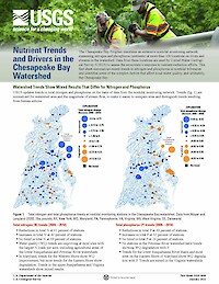
The US Geological Survey and IAN have collaborated to release a one-page fact sheet, Nutrient Trends and Drives in the Chesapeake Bay. The fact sheet quantifies trends and drivers in nutrient loading throughout the Chesapeake Bay Watershed and provides visualizations. This will help high-level managers and policymakers understand the complex processed that drive water quality, informing efforts to have nutrient reduction practices in place by 2025. You can view the full fact sheet here, or check out our short videos (Part 1, Part 2) that explain the main findings.
UMCES and USGS kick off a new science synthesis project

This project aims to translate and synthesize existing USGS scientific research and knowledge to inform conservation and restoration in the Chesapeake Bay watershed and other critical landscapes. Subject matter experts will convene virtually to develop and draft a newsletter summarizing nutrient trends in the Chesapeake Bay watershed. Participants represent UMCES, USGS, and the U.S. EPA Chesapeake Bay Program.
Now available: USGS Chesapeake Science Strategy 2021–2025
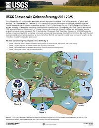
The Chesapeake Bay ecosystem is a national treasure that provides almost $100 billion annually of goods and services. The Chesapeake Bay Program (CBP), is one of the largest federal-state restoration partnerships in the United States and is underpinned by rigorous science. The U.S. Geological Survey (USGS) has a pivotal role as a science provider for assessing ecosystem condition and response in the Chesapeake watershed. Despite significant CBP accomplishments, the pressures of climate change and competing demands on land use and change require an acceleration of progress towards the 10 goals in the Chesapeake Bay Watershed Agreement. USGS Chesapeake studies are increasing efforts to provide integrated science and are engaging stakeholders to inform the multi-faceted restoration and conservation decisions to improve habitat for fish and waterfowl, and socio-economic benefits to the 18 million people living in the watershed.
Land use and cover has management implications
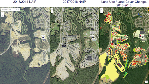
In partnership with the USGS, the IAN team produced a summary of the Chesapeake Bay Program's new Land Use/Land Cover (LULC) Project. The summary includes:
- The need to have a 1-m resolution data set
- The methods for data collection, synthesis, and mapping
- The major findings of the new data set analysis. The characterization of the types of land use show that turf grass is the largest “crop” in the watershed. The land-change analysis reveals that timber harvest produced the largest land change in the watershed
- Some management implications for the Chesapeake Watershed Agreement Goals and outcomes, including those for water quality, land conservation and healthy watershed, and vital habitat
You can view the summary on the USGS website. The LULC data sets are also available online, with 2013/2014 and 2017/2018 comparative maps.
Recent IAN publications
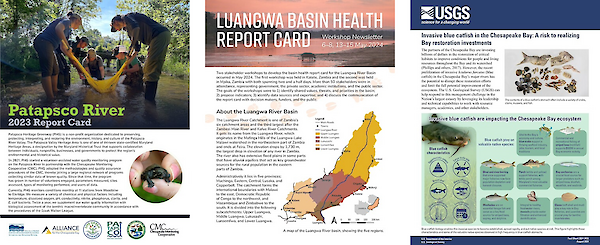
Check out some of the following publications we had last month:
- Patapsco River 2023 Report Card: This report card, produced with Patapsco Heritage Greenway as part of the Chesapeake Monitoring Cooperative, assesses the condition of the Patapsco River using volunteer monitoring data for the second year in a row.
- Luangwa River Workshop Newsletter: This newsletter summarizes the results of two stakeholder workshops held in May 2024 for the development of the Luangwa River Basin Report Card with WWF Zambia.
- Invasive blue catfish in the Chesapeake Bay: A risk to realizing Bay restoration investments: In collaboration with the U.S. Geological Survey (USGS), this fact sheet highlights the characteristics of invasive blue catfish, emphasizes the spread of blue catfish in the Chesapeake Bay over time, and informs about the capabilities of USGS to respond to this management challenge.
Highlighting USGS's Critical Bird Monitoring Programs
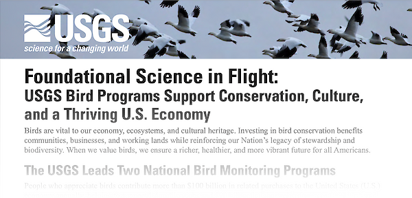
Our latest fact sheet, in partnership with the U.S. Geological Survey (USGS), was released last month, titled "Foundational Science in Flight: USGS Bird Programs Support Conservation, Culture, and a Thriving U.S. Economy." The fact sheet describes the history and critical impacts of the Bird Banding Laboratory (BBL) and the Breeding Bird Survey (BBS), two national bird monitoring programs led by the USGS. These programs have been key to informing science-based bird management and conservation while supporting the U.S. economy through birdwatching, hunting, and ecotourism. Explore the fact sheet here to discover over 100 years of progress achieved by these programs and their future objectives.