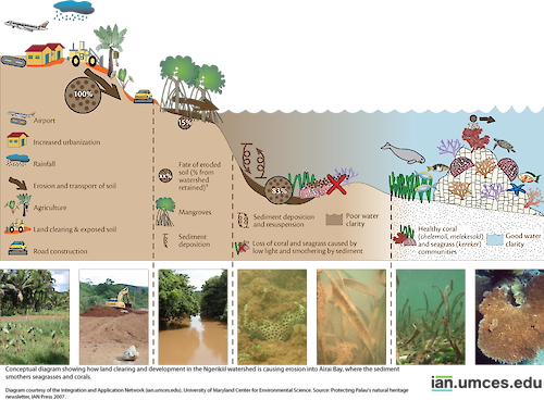
Diagram showing how land clearing and development in the Ngerikiil watershed is causing erosion into Airai Bay, where the sediment smothers seagrasses and corals
Diagram showing how land clearing and development in the Ngerikiil watershed is causing erosion into Airai Bay, where the sediment smothers seagrasses and corals.
diagram Palau Pacific Ocean coral reefs land use development sediment erosion| Property | Value |
|---|---|
| Author(s) | Jane Thomas |
| Author Company | Integration and Application Network |
| Date Created | 2007-08-06 |
| Album | Ecosystems > Coastal/Marine |
| Type | Graphic |
| Publication | Protecting Palau's natural heritage |
| Project(s) | Training Federal Agencies in Ecosystem-Based Management |
| Dimensions | 1000 x 735 |
| Filesize | 571.0 kB |
| Number of Downloads | 512 |
| Filetype(s) | PNG |
| License | Attribution-ShareAlike 4.0 International (CC BY-SA 4.0) |
| Required Attribution | Jane Thomas, Integration and Application Network (ian.umces.edu/media-library) |