

Capturing Nature on the Job
Nathan Miller · | Science Communication |
While camera phones are becoming more sophisticated with each successive generation - with increasing resolution, wider color gamut, and better depth of field - they still cannot match the image quality captured from the sensor of a DSLR (or the mirrorless cameras entering the market). Here at IAN, there’s never a moment when we as science communicators are more than an arm’s length from a decent camera, and when we see a subject that catches our attention while on the clock, we’re often encouraged to grab a camera and snap a few pictures, hoping at least one of those images captures the essence of the “something”, whatever it was that could have peeled our eyes away from our computer screens.
My office sits on the UMCES Horn Point Lab campus, and the view from my desk directly overlooks the Choptank River just before it meets the Chesapeake Bay. With spring almost over and summer about to kick into high gear, the trees have blossomed, arthropods are buzzing around, and the reptiles and mammals that hibernated during the winter are up and about. Needless to say, there have been several moments this season where I’ve dropped everything I was doing to race outside, camera in tow, to photograph the plants and animals that were just as ready for winter to leave as me!

(Photograph by Nathan Miller)
Given
these past few months have been my first living on the Eastern Shore, I’ve had
to deal with questions from my well-meaning co-workers, such as, “What, you’ve
never seen a woodchuck before?”, or “You’ve never seen mating osprey kick
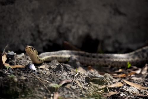
mating bald eagles out of an aerie?”, and “Nathan, do you really need a 600mm
lens to photograph a garter snake?” In my naiveté, my answers to each were,
respectively, “No, “No,” and “YES!”
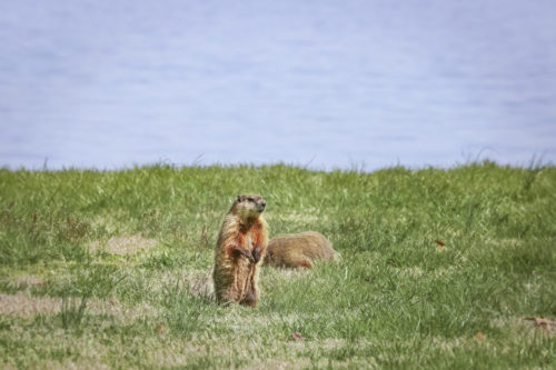
In all honesty, photographing the nature of the Horn Point Lab has been a fantastic part of my acclimation to both UMCES and the larger Eastern Shore region. Through photography, not only do I get to become acquainted with the new environment, not only do I get to observe stories of the local ecology in real time, but I also have the opportunity to commiserate with my colleagues and learn fascinating tidbits about the place I now call home. Did you know that if a woodchuck is driven out of its territory, it’s nearly impossible for that woodchuck to claim a new territory, essentially sentencing it to death? Because I didn’t until fellow Science Communicator Jamie Currie told me that just as I was photographing mating woodchucks just outside the office kitchen.
The bad
news is that a few weeks after we noticed those mating woodchucks, we observed
a mama fox and her kits foraging in the woodchuck territory, meaning the foxes
possibly drove the woodchuck out for its den or ate the woodchuck before claiming
the den for their own. The good news is that the baby foxes are adorable!! The
bad news is the foxes are skittish and hard to photograph up close.
I didn’t get to witness the ospreys
kicking the bald eagles out of the aerie here on campus, but I’m told the bald
eagles will return to the aerie in the fall, kick the ospreys out, and raise a
chick in the colder seasons. When that happens, I’ll have my camera ready.
Is photographing nature on the job
fun? Absolutely. Is it unproductive? Absolutely not (I mean, they’re featured
here in this blog right?! So I’m getting some mileage out of them!). IAN’s
mission is to present environmental data in a manner that is compelling and
accessible to policy makers and the general public. We want resource users and
communities to care about the world around them and discover how human
decisions, both small and large, affect the water we drink, the food we eat,
and the air we breathe. The report cards, brochures, and newsletters that we
develop towards this mission are, as a result, highly visual, often employing
conceptual diagrams and storytelling strategies to highlight the universal
themes we find in a particular set of data.
Whenever we are creating a regional report
card or status report, we strive to incorporate stakeholders from that region –
policy makers, managers, specialized scientists, etc. – throughout development
so that the stories our final publication conveys are not just scientifically
sound, but accurately reflect local perspectives concerning environmental
protection and resource management. Last month, two of my colleagues and I
traveled to both Puerto Rico and the U.S Virgin Islands for workshops related
to upcoming status reports of each jurisdiction’s respective coral reef
habitat. During the workshops, we listened to personal anecdotes from the 2017
hurricane season when Hurricanes Irma and Maria bombarded the Caribbean,
ripping up island infrastructure and leaving millions in the U.S. territories
without electricity and clean water for weeks after landfall.

We
also learned how the extent of damage inflicted upon coastal communities by
storm swells varied depending on the proximity of that community to a reef. Rocky,
subaquatic structures that provide the foundation for all coral reefs around
the world also happen to be extremely effective at absorbing wave energy from a
storm swell, and because most coral reefs generally sit offshore, that means a
healthy reef protects a shoreline from the worst the sea has to offer during a
natural disaster. For residents of Puerto Rico who lived through Maria, whether
their home sat just a few meters from an offshore reef could have made the
difference between housing and homelessness.
The
function of the coral reef as a protective barrier is not just supported by
anecdotal evidence; there are hard data to back up coral reefs as a shoreline
protection asset. This is a major message our counterparts in both the USVI and
Puerto Rico want to prioritize in each of their jurisdiction’s coral reef
status reports – that coral reef conservation should be a key component of any
future plan to prepare and protect an island’s citizens from stronger and more
frequent hurricanes.
I
was fortunate to have time during my trip to the territories to explore the
terrain, experience the culture, and, if lucky, capture a fraction of each
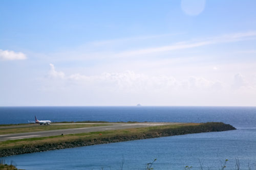
island’s dynamic character and environment with my camera. My final stop in
Puerto Rico before grabbing a cab to the airport was to the centuries-old fort
in Old San Juan. Perched right at the edge of the city’s shore, the fort offers
a jaw-dropping vista (pictured above) of the turbulent Atlantic Ocean as it
continuously slams the coast with wave after wave brought forth by powerful
winds and tidal forcings. The island’s coast extends past the horizon, and for
a significant span of the shoreline that is visible from the fort, a thin strip
of rock, partially submerged and just offshore, can be seen taking the
brunt of each wave the Atlantic throws its way, sparing the sandy beaches and
the communities behind them of direct and repeated impact.
If the camera helped me establish an intimate sense of place on the Eastern Shore, then it allowed me to process the sense of scale in the Caribbean: the scale of the ocean’s power, how terrifying and destructive that wave energy must be during a Category 5 hurricane, the expanse of the coral habitat that’s left, the speed at which those habitats are deteriorating either because of climate change, pollution or disease, and the scale of work that lies ahead of us as we as humans struggle to functionally coexist with every other living creature that calls this planet their home.
But
how exactly does photographing nature on the job actually benefit the quality
of my work? I think that was the original question I posed myself, but then I
digressed…quickly. Apologies. As I begin putting together the status reports
for both the USVI and Puerto Rico, the images I captured during the work trips
will serve as references for any text that might describe coastal dynamics
unique to the islands. They’ll also be an invaluable resource if I need to
design conceptual diagrams that accurately reflect the topography of each
territory. Some of the images may even make it into one of the status reports,
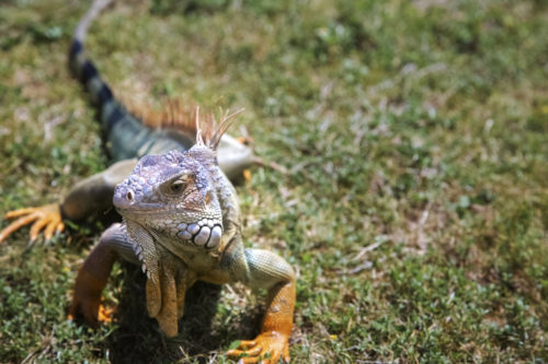
but that last one is a hard maybe. At the very least, the iguana pictured
below, grazing in a field within the San Juan fort, is adorable and will boost
morale for months to come with its beautiful colors and obviously suave
personality.
About the author
Nathan Miller

Nathan Miller received his BFA in film and television from New York University and his Masters at Duke University, where he studied coastal environmental management as well as environmental education. For his master's project at Duke, he developed an environmental interpretation manual for seal naturalists in New England. Since coming to the Integration and Application Network (IAN), Nathan has developed environmental health report cards and led or co-facilitated multiple courses on data interpretation and science communication. Scientists, managers, and students of all experiences enroll in these courses in order to gain a foundation in multimedia and storytelling strategies, which in turn helps make complex data more accessible to the general public. Nathan has also co-developed courses in collaboration with the Arnold School of Public Health at the University of South Carolina that teach graduate students how to develop stakeholder driven research projects.