Chesapeake literacy
Bill Dennison ·The concept of Chesapeake environmental literacy derives from a series of programs that have established various literacy principles, for example, ocean literacy (www.coexploration.org). These programs have distilled the essence of what an informed person needs to know, thus informing both formal (e.g., classroom) and informal (e.g., museums) educators. The literacy principles form the overall outline presented here, but it is in the richness of examples, stories and visual supporting materials that bring the literacy alive.
Seven essential principles of Chesapeake literacy are the following:
- Chesapeake Bay is a large, shallow and productive estuary formed by a drowned river valley.
- The extensive Chesapeake watershed is connected to the Bay by a myriad of streams and rivers.
- Chesapeake Bay is particularly vulnerable to runoff of nutrients, sediments and toxicants.
- Climate change and land use alteration are major drivers for Chesapeake Bay and its watershed.
- Chesapeake Bay supports unique human cultures and livelihoods.
- American history has been shaped by Chesapeake Bay.
- Chesapeake Bay is extremely well studied and intensely managed.
- Chesapeake Bay is a large, shallow and productive estuary formed by a drowned river valley. The size of Chesapeake Bay is immense (~size of Connecticut), with the mainstem stretching two hundred nautical miles (~315 km) from the mouth of the Susquehanna River to the mouth of the Bay. In addition, to the mainstem, half of the Bay is comprised of tributaries, which along with the Bay islands, form the thousands of miles of coastline. The Bay is relatively shallow, with the average depth of only 30 feet (8.5 m) and only relatively narrow deep areas formed from the drowned river valleys. The Bay was and still is incredibly productive, with abundant fish and shellfish (the name Chesapeake comes from a native American word translated as 'Great Shellfish Bay'), waterfowl, marshes and aquatic grasses.
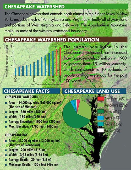
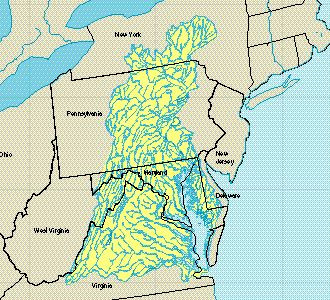
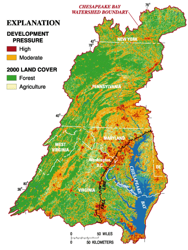
Chesapeake Bay and watershed (from IAN newsletter, Healthy Chesapeake Waterways, 2002) - The extensive Chesapeake watershed is connected to the Bay by a myriad of streams and rivers. The Chesapeake watershed extends into New York state, contains half of Pennsylvania, essentially all of Maryland, the majority of Virginia, all of the District of Columbia and includes portions of Delaware and West Virginia. The major tributaries of Virginia (e.g., James, York, Rappahannock, Potomac Rivers), Maryland (e.g., Potomac, Patuxent, Patasbco, Chester, Choptank Rivers) and Pennsylvania (Susquehanna River) are accompanied by many smaller tributaries. The rivers, creeks and streams that flow into the tributaries or directly into Chesapeake Bay dissect the watershed and there is virtually nowhere in the watershed that is more than a few miles (km) from a stream that ultimately empties into Chesapeake Bay.
- Chesapeake Bay is particularly vulnerable to runoff of nutrients, sediments and toxicants. The size, dimensions and geography of Chesapeake Bay contribute both to its high productivity and its vulnerability to the nutrient, sediment and toxicant runoff. There are various mechanisms within the Bay that serve to retain nutrients, sediments and toxicants such as the estuarine turbidity maximum, tidal and lateral fronts, hydraulic controls and eddies (Roman et al., 2005). In addition, the large watershed and shallowness of Chesapeake Bay also contribute to its vulnerability. Nutrients from a variety of natural and increasingly human sources runoff into the Bay from hundreds of point sources (e.g., sewage treatment effluent) and diffuse sources from the ~64,000 square mile (~165,000 km2) watershed. Sediments from watershed sources and coastal erosion enter the Bay and accumulate in the deeper regions, necessitating dredging to maintain shipping channels. Toxicants derived from industrial, agricultural and residential sources, power plants and automobiles, enter the waterways and ultimately Chesapeake Bay. The long residence time of Chesapeake Bay waters and sediments means that nutrients, sediments and toxicants are not readily flushed out into the ocean.
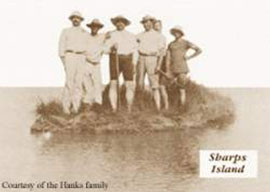
- Climate change and land use alteration are major drivers for Chesapeake Bay and its watershed. The effects of climate change on Chesapeake Bay (Naijar et al., 2010) and land use (Brush, 2008) have resulted in significant impacts on water quality, fisheries and habitats of Chesapeake Bay (Kemp et al., 2005). A major impact of climate change on Chesapeake Bay is the effect of accelerated relative sea level rise. Over the past one hundred years, many Chesapeake Bay islands have become submerged, marshes have been lost and storm surge inundations have become commonplace in historic sections of Baltimore, Washington, D.C. and Annapolis. The rate of relative sea level rise is a function of both sea level rise and land subsidence and has accelerated over the past several decades (link to Hurricane Isabel newsletter). Increased seawater temperatures have been observed in Chesapeake Bay (Preston, 2004) and projections are for warmer, wetter winters. A heat related dieback of a major submerged aquatic vegetation, eelgrass, was observed in the summer of 2005 (Orth et al., 2010). Land use change in the watershed, with more intensive agriculture, expanding urbanization and forest fragmentation have and will continue to impact Chesapeake Bay.
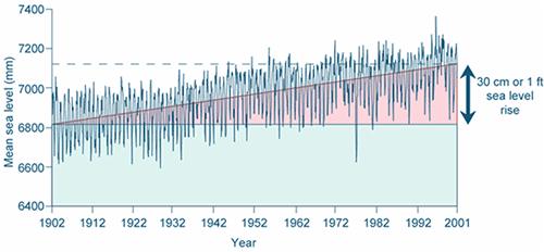
Monthly sea level data from Baltimore, showing a rise in sea level of about 1 ft (30 cm) - Chesapeake Bay supports unique human cultures and livelihoods. Approximately 50,000 Native Americans had many villages along the shores of Chesapeake Bay and included the Algonquian, Siouan and Iroquoian peoples, beginning about 10,000 years ago. Europeans first settled in Chesapeake Bay in 1607, in Jamestown, Virginia along the James River. Communities of Chesapeake Bay watermen were established and sustained their livelihoods on fisheries harvests from the Bay, in particular, oysters and blue crabs. Many islands in the Bay were inhabited by watermen and the isolation of island communities created cultures that retained an Elizabethan English dialect. The abundant fish and shellfish harvests allowed these communities to be relatively self-sufficient. Farming was also prevalent both on islands and on the mainland. Due to declining fisheries resources and sea level rise, the island communities are now restricted to a few isolated locations.

A traditional Chesapeake Bay skipjack used by watermen to dredge oyster bars (Adrian Jones, IAN Image Library) - American history has been shaped by Chesapeake Bay. Chesapeake Bay has been a strategic region throughout American history, serving as a highway for ships from Europe and other Northern American ports. The capital cities of Virginia; Jamestown, then Williamsburg and now Richmond are accessible via the James River. The capital cities of Maryland; St. Mary's and now Annapolis are accessible via the Potomac and Severn Rivers, respectively. The national capital, Washington, D.C. was created at the fall line of the Potomac River. During the Revolutionary War, many battles and skirmishes were fought along the shores of Chesapeake Bay, culminating in the British surrender at Yorktown, on the shores of the York River. During the War of 1812, British troops ransacked Washington, D.C. and then bombarded Baltimore city, prompting the "Star Spangled Banner". In the American Civil War, many of the battles were fought in the Chesapeake watershed and there were also various naval battles. In both World Wars, Chesapeake Bay was heavily defended and the site of major military installations, and there are over sixty Department of Defense installations currently (Lane et. al., 2007). Various American Presidents and federal officials have used Chesapeake Bay for recreation and residences.
- Chesapeake Bay is extremely well studied and intensely managed. Modern estuarine science had its origins in Chesapeake Bay. The first state marine laboratory, Chesapeake Biological Laboratory, was founded in 1925 by Dr. Reginald Truitt from the University of Maryland, which has developed into the University of Maryland Center for Environmental Science. The Virginia Fisheries Laboratory was founded in 1940 and is now the College of William and Mary's Virginia Institute of Marine Science. Johns Hopkins University created the Chesapeake Bay Institute in 1949 (since dissolved). Drs. Eugene Cronin, Bill Hargis and Don Pritchard, the respective directors of these institutions, led teams of scientists who described the basic physics, chemistry, biology and geology of estuaries. The scientific society Atlantic Estuarine Research Society was created in 1950, and after other regions emulated this regional society, the premier estuarine society was created in 1971; Estuarine Research Federation (now Coastal and Estuarine Research Federation). The scientific journal Chesapeake Science, started in 1960, eventually became Estuaries and Coasts. Chesapeake Bay management has been conducted by the adjacent states for over one hundred years and coordinated by the federal government through the Chesapeake Bay Program since 1983. An extensive monitoring program is coordinated by the Chesapeake Bay Program. Various other governmental and non-governmental organizations have been created to focus on management, advocacy and education, such as the Chesapeake Bay Commission, Chesapeake Bay Foundation, and the Alliance for Chesapeake Bay.
References
Brush, G. (2008) Historical land use, nitrogen and coastal eutrophication: a paleoecological perspective. Estuaries and Coasts 32: 18-28.
Kemp, W.M., W. Boynton, J. Adolf, D. Boesch, W. Boicourt, G. Brush, J. Cornwell, T. Fisher, P. Glibert, J. Hagy, L. Harding, E. Houde, D. Kimmel, W.D. Miller, R. I.E. Newell, M. Roman, E. Smith, J.C. Stevenson. (2005) Eutrophication of Chesapeake Bay: Historical trends and ecological interactions. Marine Ecology Progress Series 303: 1-29.
Lane H., J.L. Woerner, W.C. Dennison, C. Neill, C. Wilson, M. Elliot, M. Shively, J. Graine, R. Jeavons. (2007) Defending our national treasure: Department of Defense Chesapeake Bay restoration partnership: 1998-2004. Integration and Application Network, University of Maryland Center for Environmental Science. Cambridge, MD.
Najjar, R.G., C.R. Pyke, M.B. Adams, D. Breitburg, C. Hershner, M. Kemp, R. Howarth, M.R. Mulholland, M. Paolisso, D. Secor, K. Sellner, D. Wardrop, R. Wood. (2010) Potential climate-change impacts on the Chesapeake Bay. Estuarine, Coastal and Shelf Science 86: 1-20.
Orth, R.J., S.R. Marion, K.A. Moore, D.J. Wilcox. (2010) Eelgrass (Zostera marina L.) in the Chesapeake Bay region of Mid-Atlantic coast of the USA: Challenges in conservation and restoration. Estuaries and Coasts 33: 139-150.
Roman, M.R., X. Zhang, C. McGilliard, W. Boicourt. (2005) Seasonal and annual variability in the spatial patterns of plankton biomass in Chesapeake Bay. Limnol. Oceanogr. 50: 480-492.
About the author
Bill Dennison

Dr. Bill Dennison is a Professor of Marine Science and Vice President for Science Application at the University of Maryland Center for Environmental Science.


