Creating reporting boundaries for the Long Island Sound environmental report card
Bill Dennison ·One of the important decisions in developing environmental report cards is choosing the reporting region boundaries. In addition to defining the overall extent of the report card coverage, defining the reporting regions within this coverage is crucial. Since one of the central tenets of environmental report cards produced by the Integration and Application Network is facilitating comparative analyses and using peer pressure between reporting regions to elicit behavior change, we are always attempting to establish the smallest reporting regions as the data density and stakeholder opinion will allow.
In most coastal report cards there are various geographic and/or oceanographic features that make establishing report regions boundaries fairly obvious. In most watershed report cards, there are typically geographic and/or stream order features that facilitate reporting regions as well. In contrast, Long Island Sound does not easily lend itself to subdividing into reporting regions. The boundaries of the Sound itself are very strait forward, but the subdivisions are not a simple task and one that has taken some effort to develop.

Long Island Sound is formed between the glacial moraine of Long Island and the mainland coasts of New York and Connecticut. Long Island Sound tapers at both ends and is widest in the central portion. Both the northern and southern coastlines form broad arcs, perforated with small embayments, but there are no large protruding land masses that break the Sound into separate sub-basins. Thus, the difficulty in establishing reporting regions within the Sound.
We accessed a variety of data layers of natural features to establish reporting regions; bathymetry, sediment type and water currents. In addition, anthropogenic features were used, in particular, water and sediment quality gradients and sampling intensity. The first attempt is to use natural features, but it is important to consider anthropogenic features in designing reporting regions. The influence of strong gradients and adequate sampling resolution need to be factored into natural features in establishing reporting regions.
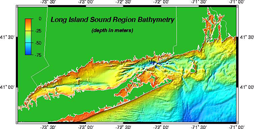
Five reporting regions were established for Long Island Sound, in order from west to east:
- Western Narrows. This reporting region is between the East River opening into Long Island Sound at the western-most boundary of the Sound (near the RFK/Triborough Bridge) and the eastern boundary denoted as an east-west line between Sands Point (between Manhasset Bay and Hempstead Harbor) on Long Island to the northern end of Pelham Bay Park on the mainland side of the Sound. The Western Narrows includes the infamous Hell Gate, three major bridges (Triborough/RFK, Whitestone, Throgs Neck), three major islands (Rikers, City, Hart).

Aerial view of the Hell Gate Bridge and the Triborough Bridge. Photo from Wikimedia Commons - Eastern Narrows. This reporting region extends from the Western Narrows to a line extending from Eatons Neck between Huntington Bay and Smithtown Bay on Long Island to Noroton Point between Fivemile River and Wilson Cove in Connecticut. The Eastern Narrows forms the northern boundaries of Hempstead Harbor, Oyster Bay, Oyster Harbor, Cold Spring Harbor, and Northport Bay on Long Island and the southern boundaries of Mamaroneck River, Milton Harbor, Greenwich Harbor, Indian Harbor, Cos Cob Harbor, Greenwich Cove, Stamford Harbor, Westcott Cove, Cove Harbor, Scott Cove and Fivemile River. There are numerous small islands along the Connecticut shoreline of the Eastern Narrows.
- Western Long Island Sound. This reporting region extends from the Eastern Narrows to a line extending from Old Field Point between Stony Brook and Port Jefferson Harbors on Long Island to Stratford Point between Black Rock and Bridgeport Harbors on the Connecticut shore. This boundary is very near the route of the Bridgeport-Port Jefferson ferry. Western Long Island Sound forms the northern boundaries of Setauket Harbor, Flax Pond and Stony Brook Harbor on Long Island and the southern boundaries of Norwalk Harbor, Saugatauk River, Sherwood Millpond, Southport Harbor and Black Rock Harbor on the Connecticut shoreline. There is a clockwise residual water circulation in this region.
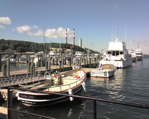
Port Jefferson. Photo by John Blyberg (Flickr) - Central Long Island Sound. This reporting region extends from Western Long Island Sound to a line extending from Roanoke Point on Long Island to Pilots Point just east of the Menunketesuck River. Central Long Island Sound forms the northern boundaries of Port Jefferson and Miller Place Harbors on Long Island and Bridgeport Harbor, Housatonic River, New Haven Harbor, Branford Harbor, Guilford Harbor, East River and Clinton Harbor on the Connecticut shoreline. There is a clockwise residual water circulation in this region.
- Eastern Long Island Sound. This reporting region extends from Central Long Island Sound to a line extending from Orient Point, Long Island and along the western shorelines of Plum, Great Gull, Little Gull and Fishers Islands to Napatree Point, Rhode Island. The body of water that this eastern boundary of Long Island Sound transits is known as 'The Race', a reflection of the rapid tidal currents that pass through a narrow channel between the islands and a shallow sill. The Long Island side of Eastern Long Island Sound is largely unbroken sand bluffs with no substantial embayments or rivers. The Connecticut side of Eastern Long Island Sound contains Westbrook Harbor, Oyster River, Connecticut River (the largest freshwater source for Long Island Sound, draining the largest watershed), Pattagansett River, Niantic Bay and Harbor, New London Harbor, Mystic Harbor, Stonington Harbor, Little Narragansett Bay and Pawcatuck River.
The rationale for the boundaries of these reporting regions are as follows:
The western boundary of the Western Narrows is the geographic and hydrological boundary between the East River (North-South orientation) and Long Island Sound (East-West orientation).
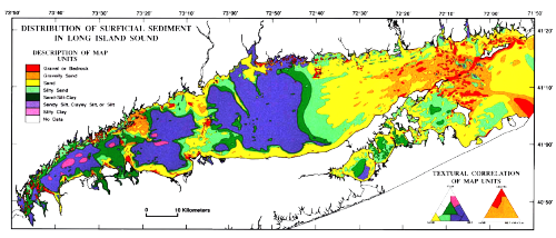
The boundary between the Western Narrows and Eastern Narrows uses a geographic feature (Sands Point) that separates the wider Eastern Narrows from the more constricted Western Narrows, and runs over Middle Reef, a shallow reef on the Connecticut side of the Sound. There is an extended submersed gravel and sand feature that this boundary follows.
The boundary between Eastern Narrows and Western Long Island Sound uses the geographic features of Eatons Neck on Long Island and the western end of the island chain protecting Norwalk Harbor on the Connecticut shore. This boundary line runs over Budd and Cable & Anchor Reefs, and along an extended submersed gravel and sand bar.
The boundary between Western and Central Long Island Sound uses the geographic features of Old Field Point on Long Island and Stratford Point, Connecticut and crosses over Stratford Shoal/Middle Ground in the middle of Long Island Sound. This boundary extends over sandy sediments that separate the silty mud in the basins on either side.
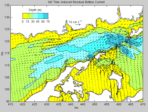
The boundary between Central and Eastern Long Island Sound is largely a bathymetric boundary; between shallow water (generally <30 m) of Central Long Island Sound and deep water (generally >30 m) in Eastern Long Island Sound maintained by scouring action of tidal currents.
The eastern boundary of Long Island Sound is a strong geographic and bathymetric boundary, with two prominent land features (Orient Point at the eastern end of the North Fork of Long Island and Napatree Point at the western end of a long peninsula in Rhode Island), and a series of islands (Plum, Great Gull, Little Gull and Fishers Islands). The bathymetry is variable, with a shallow sill (<30 m) extending from Orient Point to the Gull Islands and a deep channel (~40-70m) between the Gull Islands and Fishers Island known as 'The Race'.
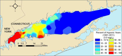
The Connecticut Department of Energy and Environmental Protection (CTDEEP) Water Quality Monitoring Program and the Long Island Sound Study (LISS) use the designations of the Narrows, Western, Central and Eastern Long Island Sound. Their boundaries for Central and Eastern Long Island Sound are exactly the same as the boundaries proposed for the report card. The boundary between the Western and Central basins differ slightly. The biggest deviation from the CTDEEP/LISS and report card boundaries is the designation of an additional basin between the Narrows and Western Long Island Sound. At a combined meeting of the LISS Science and Technical Advisory Committee (STAC) and the Citizens Advisory Committee (CAC) on 10 October 2014, the issue of boundaries was raised and the consensus was that since we had strong east-west gradients in water quality in the western regions and sufficient spatial sampling density that we should separate the Narrows into Western and Eastern Narrows, as well as Western, Central and Eastern Long Island Sound reporting regions.
About the author
Bill Dennison

Dr. Bill Dennison is a Professor of Marine Science and Vice President for Science Application at the University of Maryland Center for Environmental Science.

