

Chesapeake Bay Report Card 2018 released!

AN released the 2018 Chesapeake Bay Report, giving the Chesapeake a C grade. Due to heavy rainfall in the past year we saw many indicators stay steady or decline in their score. Over the past decade we have noticed a significant improving trend in the Chesapeake Bay. This trend will continue to improve with the collective effort of the people who live here. More information about indicators and grades is available at ecoreportcard.org.
Fact sheet on nutrient trends in the Chesapeake now available
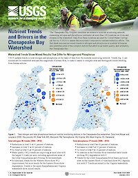
The US Geological Survey and IAN have collaborated to release a one-page fact sheet, Nutrient Trends and Drives in the Chesapeake Bay. The fact sheet quantifies trends and drivers in nutrient loading throughout the Chesapeake Bay Watershed and provides visualizations. This will help high-level managers and policymakers understand the complex processed that drive water quality, informing efforts to have nutrient reduction practices in place by 2025. You can view the full fact sheet here, or check out our short videos (Part 1, Part 2) that explain the main findings.
"Evaluating Transdisciplinary Approaches" now available online
The Evaluating Transdisciplinary Approaches Workshop was convened by the Belmont Forum last summer. Workshop participants were part of a growing community of transdisciplinary research supporters and practitioners. The workshop goals were centered around participants exploring transdisciplinary research goals, metrics, and assessment. This workshop newsletter compiles the results of the workshop, outlines recommendations for how to evaluate transdisciplinary approaches, and provides current and past examples of transdisciplinary research.
Chesapeake Bay Watershed Report Card released!
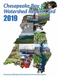
On May 19th, Chesapeake Bay Watershed Report Card was released during a virtual event. Speakers included Dr. Peter Goodwin, Dr. Bill Dennison, Secretary Ben Grumbles, Secretary Matthew J. Strickler, Ann Swanson, Kate Fritz, Jake Reilly, and Secretary Jeannie Haddaway-Riccio. For the first time, Chesapeake Bay watershed health was scored as part of the report card and scored a B- grade. The Chesapeake Bay health score decreased in 2019, dropping from a grade of C to a C-. In addition to ecological indicators, societal indicators were included for the first time. There were over 90 people watching the live webinar event, and 95 million people were reached through traditional and social media. You can view the full report card document here or visit the report card website here.
UMCES and USGS kick off a new science synthesis project
This project aims to translate and synthesize existing USGS scientific research and knowledge to inform conservation and restoration in the Chesapeake Bay watershed and other critical landscapes. Subject matter experts will convene virtually to develop and draft a newsletter summarizing nutrient trends in the Chesapeake Bay watershed. Participants represent UMCES, USGS, and the U.S. EPA Chesapeake Bay Program.
Revamping the Chesapeake Bay Report Card
From January 7–8, IAN staff traveled to Harrisburg, PA for a workshop to expand the Chesapeake Bay Report Card. Bill, Caroline, Alex, Sky, and Vanessa facilitated and presented at the workshop. The workshop brought together stakeholders to discuss how to include watershed and socioeconomic data in future report cards. Watershed reporting regions were developed and numerous new indicators were discussed. Moving forward, there will be another workshop held in Virginia this spring to further refine the indicators and data analysis methodology.
SAV watchers
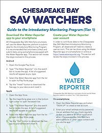
We developed a system for citizen science monitoring of Submersed Aquatic Vegetation (SAV) in the Chesapeake Bay. Using the new system, volunteers can collect consistent and useful SAV data.
Now available: USGS Chesapeake Science Strategy 2021–2025
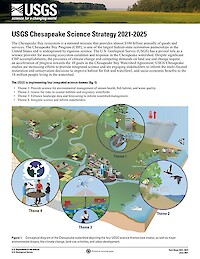
The Chesapeake Bay ecosystem is a national treasure that provides almost $100 billion annually of goods and services. The Chesapeake Bay Program (CBP), is one of the largest federal-state restoration partnerships in the United States and is underpinned by rigorous science. The U.S. Geological Survey (USGS) has a pivotal role as a science provider for assessing ecosystem condition and response in the Chesapeake watershed. Despite significant CBP accomplishments, the pressures of climate change and competing demands on land use and change require an acceleration of progress towards the 10 goals in the Chesapeake Bay Watershed Agreement. USGS Chesapeake studies are increasing efforts to provide integrated science and are engaging stakeholders to inform the multi-faceted restoration and conservation decisions to improve habitat for fish and waterfowl, and socio-economic benefits to the 18 million people living in the watershed.
Land use and cover has management implications
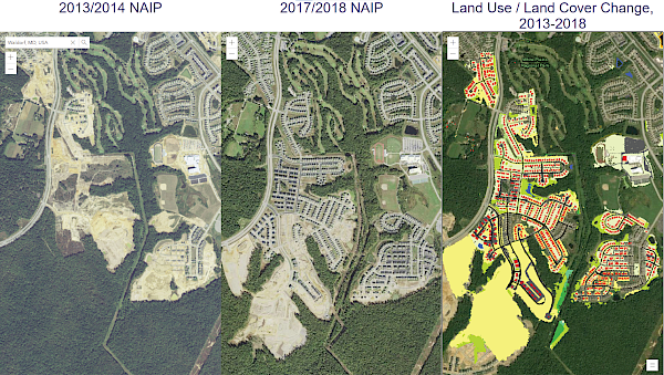
In partnership with the USGS, the IAN team produced a summary of the Chesapeake Bay Program's new Land Use/Land Cover (LULC) Project. The summary includes:
- The need to have a 1-m resolution data set
- The methods for data collection, synthesis, and mapping
- The major findings of the new data set analysis. The characterization of the types of land use show that turf grass is the largest “crop” in the watershed. The land-change analysis reveals that timber harvest produced the largest land change in the watershed
- Some management implications for the Chesapeake Watershed Agreement Goals and outcomes, including those for water quality, land conservation and healthy watershed, and vital habitat
You can view the summary on the USGS website. The LULC data sets are also available online, with 2013/2014 and 2017/2018 comparative maps.