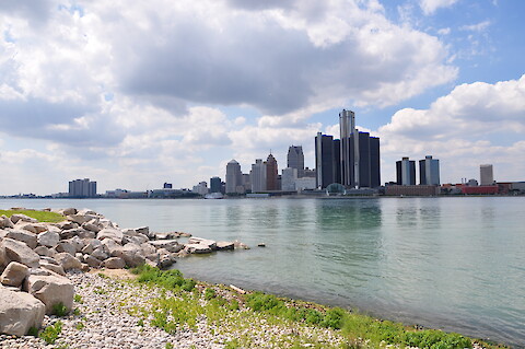
Since working with UMCES on the first report card in 2014, Georgia Department of Natural Resources Coastal Resources Division (Georgia DNR) has been producing a report card each year for the last five years. The objectives of this project are to conduct a virtual workshop for the Georgia DNR staff and other stakeholders to review the past report cards and revise the report card for the future.
Between July 2020 to January 2021, the Integration and Application Network collaborated with the Maryland Department of Environment to develop communication products that promote the state's Water Quality Trading Program. Maryland’s Water Quality Trading Program creates a public market for nitrogen, phosphorus and sediment reductions.
WWF with partners in the region will be developing a ‘Resilient Basin Report Card’ to assesses the challenges in the Upper Rio Grande sub-basin and provide recommendations on climate-smart responses to address them.
Coordination between the Chesapeake Bay Program and it's partners is integral to the improvement of the health of people and lands within the Chesapeake Bay Watershed. IAN personnel spearhead this coordination and ensure communication channels are open and information is readily shared between partners.
IAN staff help to lead the State’s efforts in identifying new restoration practices for water quality restoration through Maryland’s Innovative Technology Fund. Our team integrates emerging data into programs that prioritize restoration strategies and highlights how policy, regulation and legislation can enhance the implementation of cost effective best management practices.
Translation of scientific research into accessible documents is relevant to USGS’s overall mission and goals but specifically germane to the Chesapeake Bay science and restoration community. The Chesapeake Bay Program partnership, in which the USGS plays a key role, is working toward restoring the Chesapeake Bay watershed.
Through increased funding, planning, regulation, and restoration, Maryland has become a leader in coastal and climate adaptation. There is, however, a need to clarify adaptation goals to measure progress and hold the state accountable.
The main objective of this project is to leverage machine learning approaches -- more specifically, the combined use of hierarchical clustering and random forest (RF) classification -- to reveal regional patterns and drivers of nitrogenand phosphorus trends across the Chesapeake Bay watershed. This work involves three objectives:
The Darwin Harbour Report Card is a partnership of universities and provincial governments collaborating to evaluate the social, environmental and economic health of the Darwin Harbour region in the Northern Territory of Australia. The project seeks to engage the people of Darwin Harbour and scientific experts to gain an understanding of the pressures and state of Darwin Harbour lands and waters.
The objective of this project is to develop an extension of the flow-normalization (FN) procedure of the WRTDS (“Weighted Regressions on Time, Discharge, and Season”) method. This extension is being applied to the Chesapeake Bay Nontidal Monitoring Network to quantify water-quality trends under different flow conditions and to guide the direction of additional analysis for capturing the underlying drivers, which can inform management strategies toward improving water quality.