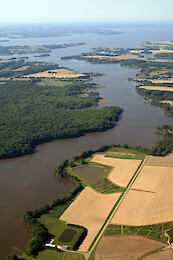
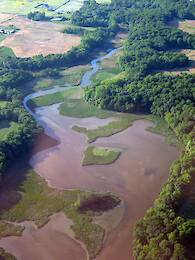
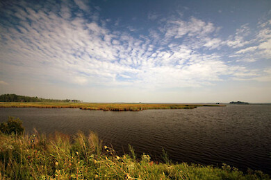
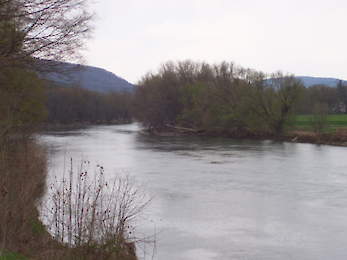
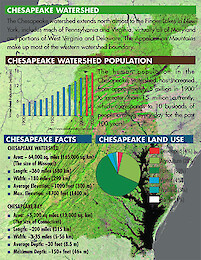
• All
  • People
  • Publications
  • Media Library
  • Blog Posts
  • Enewsletter Articles
  • All results

    280 results for "chester":

    • Chester River
      Chester River ... Looking towards the mouth of the Chester River. Southeast Creek is in the foreground ... Chesapeake Bay, Chester River, agriculture, farms, shoreline ... Jane T...
    • Chester River
      Chester River ... Looking across the Chester River. Southeast Creek is in the foreground, and Chestertown is in the background ... Chesapeake Bay, Chester River, agriculture, farms, shoreline ... Jane Thomas...
    • Chestertown
      Chestertown ... Chestertown on the Chester River, with the Route 213 bridge. ... Chesapeake Bay, Chester River, agriculture, farms, shoreline ... Jane Thomas...
    • Kent Island and the Chester River
      Kent Island and the Chester River ... Looking north from the north shore of Kent Island over the mouth of the Chester River. Castle Marina is in the foreground. ... Chesapeake Bay, aerial, agriculture, farms, Chester River, shoreline ......
    • Kent Narrows
      ...and. The Kent Island bridge and Bay Bridge are visible. Eastern Bay is on the southern (left) side of Kent Narrows; the Chester River is on the northern (right) side. ... Chesapeake Bay, aerial, agriculture, farms, Chester River, shoreline ... Jan...
    • Kent Narrows
      ...rows to Kent Island. The Kent Island bridge is visible. Eastern Bay is on the southern (left) side of Kent Narrows; the Chester River is on the northern (right) side. ... Chesapeake Bay, aerial, agriculture, farms, Chester River, shoreline ... Jan...
    • Quaker Neck
      Quaker Neck ... Looking across Quaker Neck to Langford Creek, a tributary of the Chester River ... Chesapeake Bay, aerial, agriculture, farms, Chester River, shoreline ... Jane Thomas...
    • Eastern Neck
      Eastern Neck ... Looking across Eastern Neck which separates the Chester River (foreground) from the mainstem of the Chesapeake Bay (background). Grays Inn Creek is at the far right. ... Chesa...
    • Eastern Neck National Wildlife Refuge
      ... Wildlife Refuge. Kent Island and the Bay Bridge are in the background. ... Chesapeake Bay, aerial, agriculture, farms, Chester River, shoreline ... Jane Thomas...
    • Quaker Neck
      ...ngford Creek (background, left) from the East Fork (background, right). ... Chesapeake Bay, aerial, agriculture, farms, Chester River, shoreline ... Jane Thomas...
    • Quaker Neck
      ... Neck, which separates the West Fork of the Langford Creek (background) from the East Fork (mid-ground). Comegys Bight (Chester River) is in the foreground. ... Chesapeake Bay, aerial, agriculture, farms, Chester River, shoreline ... Jane Thomas...
    • Spaniard Neck
      Spaniard Neck ... Looking west along Spaniard Neck, which separates the Corsica River (left) from the Chester River. ... Chesapeake Bay, aerial, agriculture, farms, Chester River, shoreline ... Jane Thomas...
    • The mouth of the Corsica River
      The mouth of the Corsica River ... The mouth of the Corsica River, where it joins the Chester River. ... Chesapeake Bay, aerial, agriculture, farms, Chester River, shoreline ... Jane Thomas...
    • Beneficial use of dredged material to restore Chesapeake Bay wetlands
      ...uate the key ecological, economic, and engineering issues associated with a large scale marsh restoration project in Dorchester County. ... Emily Benson ... Heather Lane ... Jane Thomas...
    • Horn Point Laboratory
      ...r, Cambridge, plumes, rain, sediment, Horn Point Laboratory, environmental, science, research, boats, farms, fields, Dorchester County ... Jane Thomas...
    • Horn Point Laboratory
      ...r, Cambridge, plumes, rain, sediment, Horn Point Laboratory, environmental, science, research, boats, farms, fields, Dorchester County ... Jane Thomas...
    • Horn Point Laboratory
      ...r, Cambridge, plumes, rain, sediment, Horn Point Laboratory, environmental, science, research, boats, farms, fields, Dorchester County ... Jane Thomas...
    • Horn Point Laboratory
      ...r, Cambridge, plumes, rain, sediment, Horn Point Laboratory, environmental, science, research, boats, farms, fields, Dorchester County ... Jane Thomas...
    • Sediment plumes around Horn Point
      ... Chesapeake Bay, MarylandChoptank River, Cambridge, plumes, rain, sediment, Horn, Point, fields, farms, agriculture, Dorchester County ... Jane Thomas...
    • Blackwater National Wildlife Refuge
      ...Wildlife Management Area. ... Blackwater National Wildlife Refuge, Fishing Bay, Wildlife, Management, Area, marshes, Dorchester County ... Jane Thomas...
    • Blackwater National Wildlife Refuge
      ...Wildlife Management Area. ... Blackwater National Wildlife Refuge, Fishing Bay, Wildlife, Management, Area, marshes, Dorchester County ... Jane Thomas...
    • Blackwater National Wildlife Refuge
      ...Wildlife Management Area. ... Blackwater National Wildlife Refuge, Fishing Bay, Wildlife, Management, Area, marshes, Dorchester County ... Jane Thomas...
    • Blackwater National Wildlife Refuge
      ...Wildlife Management Area. ... Blackwater National Wildlife Refuge, Fishing Bay, Wildlife, Management, Area, marshes, Dorchester County ... Jane Thomas...
    • Blackwater National Wildlife Refuge
      ...Wildlife Management Area. ... Blackwater National Wildlife Refuge, Fishing Bay, Wildlife, Management, Area, marshes, Dorchester County ... Jane Thomas...
    • Blackwater National Wildlife Refuge
      ...Wildlife Management Area. ... Blackwater National Wildlife Refuge, Fishing Bay, Wildlife, Management, Area, marshes, Dorchester County ... Jane Thomas...