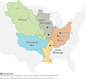
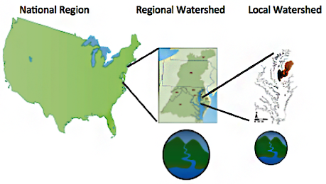
Mississippi River Watershed Map ... The Mississippi River Watershed includes six sub-basins and stretches across 31 states and two Canadian provinces. Each sub-basin has...
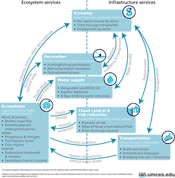
... depicts potential indicators for the Arkansas River and Red River sub-basin, one of the five major sub-basins of the Mississippi River. ... diagram, Arkansas River, Red River, Mississippi, economy, recreation, transportation, water supply, flood...
River barge ... River barge with tugboat, as often seen on the Mississippi River and used to transport commodities up or down the river. ... boat, tonnage, water, transportation, economy ... J...
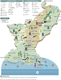
Threats and Features of the Lower Mississippi River Basin ... The Lower Mississippi River Basin supports a diversity of uses, dependent upon both natural and human engineered systems. This conceptual d...
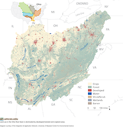
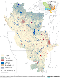
Upper Mississippi River River sub-basin land use ... This map depicts land use in the Upper Mississippi River River sub-basin, one of the five major sub-basins of the Mississippi River. ... diagram, Upper Mississippi, cro...
USA LA MS: West Mississippi Sound ... Illustration map of West Mississippi Sound in Louisiana and Mississippi, USA ... map, ecosystem, geography, geographical, USA, United States of America, LA, Louisiana, MS, Mississippi, AL,...
...phy, geographical, USA, United States of America, LA, Louisiana, Atchafalaya Bay, Basin, Swamp River, Vermillion Bay, Mississippi River, delta, Gulf, of, Mexico ... Tracey Saxby ... Kate Boicourt...
... ecosystem, geography, geographical, USA, United States of America, LA, Louisiana, Breton, Sound, Chandeleur Islands, Mississippi River, delta, Gulf, of, Mexico ... Tracey Saxby ... Kate Boicourt...
...s of America, LA, Louisiana, Lake, Borgne, St. Catherine, Rigolets, Strait, Chef, Menteur, Pass, Lake, Pontchartrain, Mississippi River, delta, Gulf, Coast, of, Mexico ... Tracey Saxby ... Kate Boicourt...
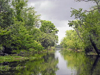
USA LA: Mississippi River ... Illustration map of Mississippi River in Louisiana, USA ... map, ecosystem, geography, geographical, USA, United States of America, LA, Louisiana, Mi...
USA MS: East Mississippi Sound ... Illustration map of East Mississippi Sound in Mississippi, USA ... map, ecosystem, geography, geographical, USA, United States of America, MS, Mississippi, AL, Alabama, East,...
...n directly followed the panel, and was hosted at the nearby Science Museum of Minnesota . It was fun to check out the Mississippi River Visitor Center , say hello to some of my colleagues, meet new people, and spot some 'famous' faces in the crowd...
...alls. Of course, visitors also enjoyed an exhibit on the ecology and natural history of the city's pride and joy: the Mississippi River, which flows outside the museum's windows. My absolute favorite museum exhibit of all time was the Collect...
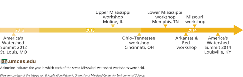
...’s symposium was ‘Large River Basins’ which was quite topical for the IAN team completing the draft Mississippi River report card . The location of the symposium in Australia’s capital city Canberra was appropriately within...
...leans and a short distance from Nashville , TN, the country music capital, it seemed appropriate to capture our lower Mississippi River workshop in the form of a blues song. Memphis is where Sam Phillips at Sun Records recorded such music luminari...
...rt cards provide a transparent snapshot of the health of systems ranging in size from the Chester River to the entire Mississippi River Watershed . Considering the great range of potential locations, watershed areas, and population sizes depicted...
...downtown Baton Rouge, just a few blocks south of the State Capitol Building . They have wonderful views of the mighty Mississippi River and the State Capital. The Water Institute Chief Scientist is Dr. Denise Reed , a hydrologist who spearheaded t...
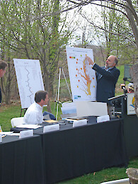
...ers Workshop in Tulsa, Oklahoma ... As part of our continuing series of stakeholder expert workshops for developing a Mississippi River basin report card , a team of IAN Science Integrators and Science Communicators traveled to Tulsa , Oklahoma on...
Assembling Indicators for a Mississippi River Basin Report Card ... The report card for the Mississippi River basin. The purpose of this report card is to provide people with information on status and trends of the entire...
...marked the first use of socioeconomic indicators like income, recreation, and transportation in a report card for the Mississippi River. 3 This proved to be a catalyst for action, providing holistic metrics that policymakers could use to set resto...