Join the Celebration!


Celebrating 100 Years of Science! | 1925-2025

  • UMCES HOME
  • DONATE

Search form

  • Work with Us
    • Science communication services
    • Environmental report card production
    • Training and capacity building
    • Stakeholder Engagement
    • Careers
  • Media Library
    • Symbols
    • Graphics
    • Photos
    • Videos
  • Report cards
  • Education
    • Professional Certificate
    • MEES Graduate Program
    • Short Courses
    • Initiatives
  • Blog
  • Enewsletter
  • Publications
    • Books
    • Report Cards
    • Newsletters
    • Reports
    • Brochures
    • Posters
    • Papers
  • Projects
  • About
    • Who we are
    • What we do
    • Our Mission
    • History
    • Partnerships
    • Contact
    • Land Acknowledgment Statement
    • Project Videos
  • Home
  • Search
  • All
  • People
  • Publications
  • Media Library
  • Blog Posts
  • Enewsletter Articles
  • Projects
  • Pages
  • All results

    199 results for "Mississippi":

    • Alligator in the Everglades
      ...d, wetland, wetlands, royal palm, Florida, South Florida, alligator, american alligator, reptile, wildlife, Alligator mississippiensis, crocodilian ... Alexandra Fries...
    • Alligator mississippiensis (American Alligator)
      Alligator mississippiensis (American Alligator) ... Illustration of Alligator mississippiensis (American Alligator) ... reptile, Alligator, mississippiensis, American, alligator, Chordata, Vertebrata, Reptil...
    • Alligator mississippiensis (American Alligator) on log
      Alligator mississippiensis (American Alligator) on log ... Alligator on a log over glass smooth water. ... Alligator mississippiensis, American Alligator, reptile, water, alligator, B-roll, nature, ... Jamie Currie...
    • Alligators
      ..., NERR, National Estuarine Research Reserve, swamp, marsh, low, country, park, forest, wetland, alligator, Alligator, mississippiensis ... Caroline Donovan...
    • Conceptual diagram showing features and threats of the Arkansas River and Red River sub-basin
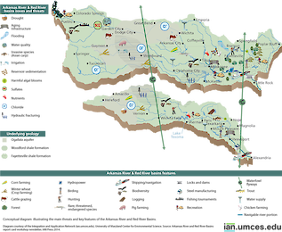
      ... main threats and key features of the Arkansas River and Red River sub-basin, one of the five major sub-basins of the Mississippi River. ... diagram, Arkansas River, Red River, Mississippi, Midwest, river, basin ... Jane Thomas...
    • Conceptual diagram showing features and threats of the Missouri River sub-basin
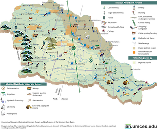
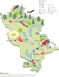
      ...llustrates the main threats and key features of the Missouri River sub-basin, one of the five major sub-basins of the Mississippi River. ... diagram, Missouri, Mississippi, Midwest, river, basin ... Jane Thomas...
    • Diagram showing ecosystems of the Chenier Plain of coastal Louisiana
      ...f coastal Louisiana ... Diagram showing ecosystems of the Chenier Plain of coastal Louisiana. ... diagram, Louisiana, Mississippi, delta, chenier, plain, hydrology, ecosystems, sediment ... Jane Thomas...
    • Diagram showing ecosystems of the Deltaic Plain of coastal Louisiana
      ...f coastal Louisiana ... Diagram showing ecosystems of the Deltaic Plain of coastal Louisiana. ... diagram, Louisiana, Mississippi, delta, chenier, plain, hydrology, ecosystems, sediment ... Jane Thomas...
    • Diagram showing features of and threats to coastal Louisiana
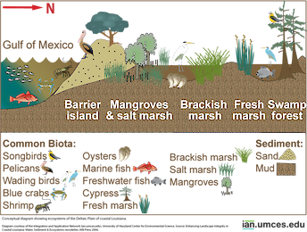
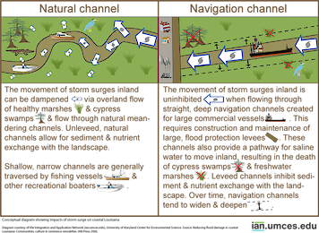
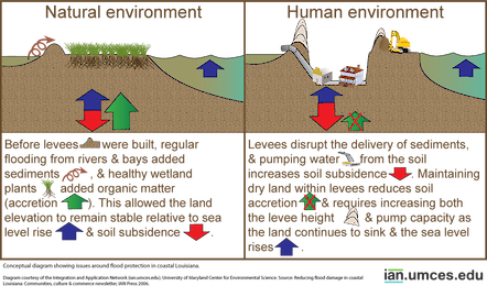
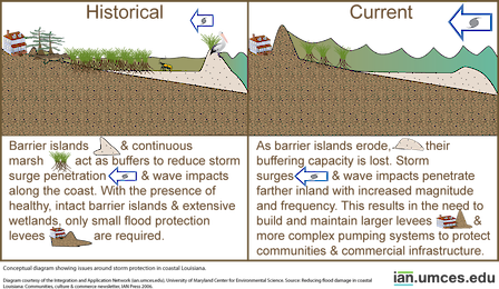
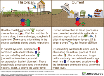
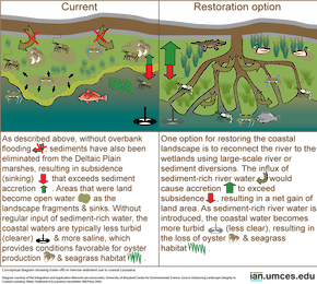
      ...hreats to coastal Louisiana ... Diagram showing features of and threats to coastal Louisiana. ... diagram, Louisiana, Mississippi, storm surge, flood protection, renewable resources ... Jane Thomas...
    • Diagram showing hydrology of the Deltaic Plain of coastal Louisiana
      ...of coastal Louisiana ... Diagram showing hydrology of the Deltaic Plain of coastal Louisiana. ... diagram, Louisiana, Mississippi, delta, chenier, plain, hydrology, ecosystems, sediment ... Jane Thomas...
    • Diagram showing hydrology on the Chenier Plain of coastal Louisiana
      ...of coastal Louisiana ... Diagram showing hydrology on the Chenier Plain of coastal Louisiana. ... diagram, Louisiana, Mississippi, delta, chenier, plain, hydrology, ecosystems, sediment ... Jane Thomas...
    • Diagram showing impacts of storm surge on coastal Louisiana
      ...m surge on coastal Louisiana ... Diagram showing impacts of storm surge on coastal Louisiana. ... diagram, Louisiana, Mississippi, storm surge, flood protection, renewable resources ... Jane Thomas...
    • Diagram showing issues around flood protection in coastal Louisiana
      ...in coastal Louisiana ... Diagram showing issues around flood protection in coastal Louisiana. ... diagram, Louisiana, Mississippi, storm surge, flood protection, renewable resources ... Jane Thomas...
    • Diagram showing issues around storm protection in coastal Louisiana
      ...in coastal Louisiana ... Diagram showing issues around storm protection in coastal Louisiana. ... diagram, Louisiana, Mississippi, storm surge, flood protection, renewable resources ... Jane Thomas...
    • Diagram showing the effects of sacrificing renewable natural resources in coastal Louisiana
      ... Diagram showing the effects of sacrificing renewable natural resources in coastal Louisiana. ... diagram, Louisiana, Mississippi, storm surge, flood protection, renewable resources ... Jane Thomas...
    • Diagram showing the landscape of the Chenier and Deltaic Plains of coastal Louisiana
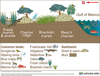
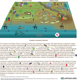
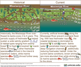
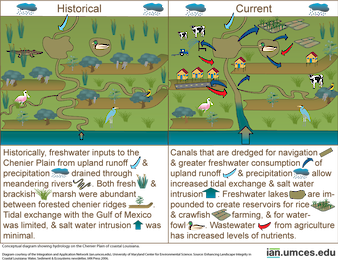
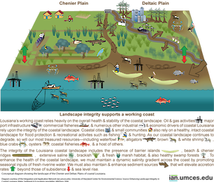
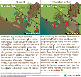
      ...ana ... Diagram showing the landscape of the Chenier and Deltaic Plains of coastal Louisiana. ... diagram, Louisiana, Mississippi, delta, chenier, plain, hydrology, ecosystems, sediment ... Jane Thomas...
    • Diagram showing trade-offs in Deltaic and Chenier Plain sediment use in coastal Louisiana
      ..... Diagram showing trade-offs in Deltaic and Chenier Plain sediment use in coastal Louisiana. ... diagram, Louisiana, Mississippi, delta, chenier, plain, hydrology, ecosystems, sediment ... Jane Thomas...
    • Diagram showing trade-offs in riverine sediment use in coastal Louisiana
      ...astal Louisiana ... Diagram showing trade-offs in riverine sediment use in coastal Louisiana. ... diagram, Louisiana, Mississippi, delta, chenier, plain, hydrology, ecosystems, sediment ... Jane Thomas...
    • Flow Capacity for the Mississippi River
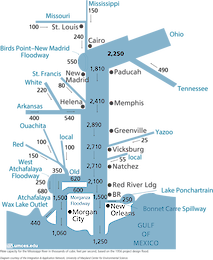
      Flow Capacity for the Mississippi River ... A diagram illustrates the flow capacity for the Mississippi River in thousands of cubic feet per second, based on the 1956 project design flood. The Ohio river is the 200,000 sq...
    • Land use in the Arkansas River and Red River sub-basin
      ... ... This map depicts land use in the Arkansas River and Red River sub-basin, one of the five major sub-basins of the Mississippi River. ... diagram, Arkansas River, Red River, Mississippi, crops, forest, developed, water, shrub, scrub, wetlands,...
    • Land use map of the Missouri River basin
      ...ri River basin ... This map depicts land use in the Missouri River sub-basin, one of the five major sub-basins of the Mississippi River. ... diagram, Missouri, Mississippi, crops, forest, developed, water, shrub, scrub, wetlands, barren, Midwest,...
    • Lower Mississippi Land Cover Map
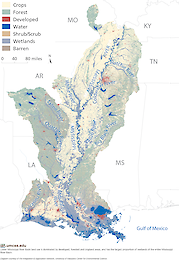
      Lower Mississippi Land Cover Map ... Lower Mississippi land use is dominated by developed, forested and cropland areas, and has the largest proportion of wetlands of the en...
    • Lower Mississippi Workshop Connections
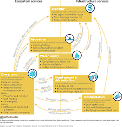
      Lower Mississippi Workshop Connections ... Several connections were made at the Lower Mississippi River Basin workshops. These connections will be used to develop a basin-wide report card for the watershed. ... diag...
    • Main Threats and Key Features of the Ohio River Basin
      ...d-workshop-newsletter/ ... diagram, Ohio, river, basin, threats, features, issues, geology, development, agriculture, Mississippi ... Jane Thomas...
    • Main Threats and Key Features of the Upper Mississippi River Sub-Basin
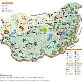
      Main Threats and Key Features of the Upper Mississippi River Sub-Basin ... A conceptual diagram illustrates the main threats and key features of the Upper-Mississippi River...
    • Prev
    • 1
    • 2
    • 3
    • 4
    • 5
    • 6
    • 7
    • 8
    • Next

UMCES Links

  • Home
  • About
  • Campuses
  • News & Events
  • Directory
  • Employment
  • Research
  • Press Room

Contact Info

2020 Horns Point Rd
Cambridge, MD 21613

410-221-2048

Contact

Enewsletter

Subscribe to our enewsletter

Copyright 2025 UMCES | Privacy/Terms of Use | An Institution of the University System of Maryland