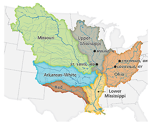
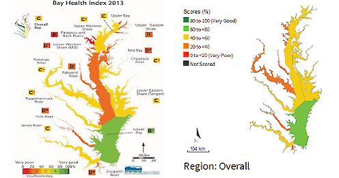
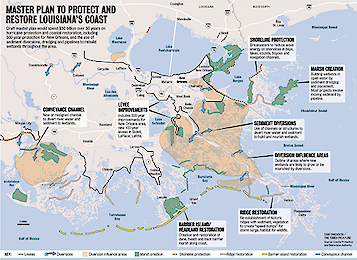
Join the Celebration!


Celebrating 100 Years of Science! | 1925-2025

  • UMCES HOME
  • DONATE

Search form

  • Work with Us
    • Science communication services
    • Environmental report card production
    • Training and capacity building
    • Stakeholder Engagement
    • Careers
  • Media Library
    • Symbols
    • Graphics
    • Photos
    • Videos
  • Report cards
  • Education
    • Professional Certificate
    • MEES Graduate Program
    • Short Courses
    • Initiatives
  • Blog
  • Enewsletter
  • Publications
    • Books
    • Report Cards
    • Newsletters
    • Reports
    • Brochures
    • Posters
    • Papers
  • Projects
  • About
    • Who we are
    • What we do
    • Our Mission
    • History
    • Partnerships
    • Contact
    • Land Acknowledgment Statement
    • Project Videos
  • Home
  • Search
  • All
  • People
  • Publications
  • Media Library
  • Blog Posts
  • Enewsletter Articles
  • Projects
  • Pages
  • All results

    198 results for "Mississippi":

    • We're all connected to the Big Easy: Beyond Science into BIG Management of Coastal Louisiana Ecosystem
      ...ver, the process prevents overflow and sediment deposition, thus wetlands deteriorate. It is shocking that CL and the Mississippi Deltaic Plain (MDP) are experiencing land loss at a rate as high as 100 km2/year3,4, almost exclusively due to the an...
    • A visit to The Water Institute of the Gulf in Baton Rouge
      ...downtown Baton Rouge, just a few blocks south of the State Capitol Building . They have wonderful views of the mighty Mississippi River and the State Capital. The Water Institute Chief Scientist is Dr. Denise Reed , a hydrologist who spearheaded t...
    • Ending a NOAA partnership and beginning a new EcoCheck chapter
      ...ng frameworks for iconic locations like the Great Barrier Reef , the South Pacific islands , Gulf of Mexico , and the Mississippi River basin . EcoCheck has developed report cards in diverse locations; Kura River in Central Asia , Samoa , and the...
    • Mississippi River Report Card Vision and Framework
      Mississippi River Report Card Vision and Framework ... In September, America’s Great Watershed Initiative (AGWI) held a sum...
    • Brisbane 2011: Living with Floods and Dancing with Dugongs: Part 7- Examples of Flooding in the United States
      ..., they're now turning their attention, in the next year, to developing this master plan . This is where they take the Mississippi River water, which is sediment laden, because it drains half of North America, and they're going to divert it into th...
    • Brisbane 2011: Living with Floods and Dancing with Dugongs: Part 6- Global Initiatives in Response to Flooding
      ... America that I have been working with; the Chesapeake Bay on the east coast, and coastal Louisiana--the mouth of the Mississippi River with marshes and the city of New Orleans. Let's look at the two major floods and how people have responded to t...
    • Developing a Gulf of Mexico report card
      ...ple attending this Joint Meeting, with representatives from each of the five Gulf of Mexico states (Texas, Louisiana, Mississippi, Alabama, and Florida) and a few Mexican scientists also in attendance. Dr. Porfinio Alvarez-Torres spoke about the v...
    • Gulf of Mexico Summit 2011
      ... seagrass beds has occurred around the Gulf but notable recoveries exist in some areas (illustrated above), including Mississippi barrier islands, West Galveston Bay Texas, and Tampa Bay Florida. Trends were reversed by management and restoration...
    • Discussion following Bob Hirsch seminar on Are we making progress? Interpreting the nutrient flux records for the major rivers flowing to the Chesapeake Bay
      ...eatment technologies change, there will be time lags which will need to be analyzed. Bob pointed out that analyses of Mississippi River fertilizer applications led to a 7-10 year lag in the receiving water quality. Audience at the seminar The ques...
    • Alligator
      ...tional Estuarine Research Reserve, swamp, marsh, palmetto, low, country, park, forest, wetland, Alligator, alligator, mississippiensis ... Ben Fertig...
    • Alligator
      ...tional Estuarine Research Reserve, swamp, marsh, palmetto, low, country, park, forest, wetland, alligator, Alligator, mississippiensis ... Ben Fertig...
    • Alligator
      ...tional Estuarine Research Reserve, swamp, marsh, palmetto, low, country, park, forest, wetland, alligator, Alligator, mississippiensis ... Ben Fertig...
    • Alligator
      ...tional Estuarine Research Reserve, swamp, marsh, palmetto, low, country, park, forest, wetland, alligator, Alligator, mississippiensis ... Ben Fertig...
    • Discussion following Walter Boynton seminar on Corsica River estuary restoration
      ...in water on the landscape for longer periods before it made its way into the Bay. He provided examples from the upper Mississippi River, where scientists conducted experiments on river oxbows and observed rapid nitrate disappearance (due to denitr...
    • USA MS: East Mississippi Sound
      USA MS: East Mississippi Sound ... Illustration map of East Mississippi Sound in Mississippi, USA ... map, ecosystem, geography, geographical, USA, United States of America, MS, Mississippi, AL, Alabama, East,...
    • USA LA: Lake Borgne
      ...s of America, LA, Louisiana, Lake, Borgne, St. Catherine, Rigolets, Strait, Chef, Menteur, Pass, Lake, Pontchartrain, Mississippi River, delta, Gulf, Coast, of, Mexico ... Tracey Saxby ... Kate Boicourt...
    • USA LA: Lake Pontchartrain
      ...es of America, LA, Louisiana, Lake, Pontchartrain, Rigolets, Strait, Chef, Menteur, Pass, Lake, Borgne, New, Orleans, Mississippi River, delta, Gulf, Coast, of, Mexico ... Tracey Saxby ... Kate Boicourt...
    • USA LA: Mississippi River
      USA LA: Mississippi River ... Illustration map of Mississippi River in Louisiana, USA ... map, ecosystem, geography, geographical, USA, United States of America, LA, Louisiana, Mi...
    • USA LA MS: West Mississippi Sound
      USA LA MS: West Mississippi Sound ... Illustration map of West Mississippi Sound in Louisiana and Mississippi, USA ... map, ecosystem, geography, geographical, USA, United States of America, LA, Louisiana, MS, Mississippi, AL,...
    • USA LA: Atchafalaya and Vermillion Bays
      ...phy, geographical, USA, United States of America, LA, Louisiana, Atchafalaya Bay, Basin, Swamp River, Vermillion Bay, Mississippi River, delta, Gulf, of, Mexico ... Tracey Saxby ... Kate Boicourt...
    • USA LA: Breton and Chandeleur Sound
      ... ecosystem, geography, geographical, USA, United States of America, LA, Louisiana, Breton, Sound, Chandeleur Islands, Mississippi River, delta, Gulf, of, Mexico ... Tracey Saxby ... Kate Boicourt...
    • Alligator mississippiensis (American Alligator)
      Alligator mississippiensis (American Alligator) ... Illustration of Alligator mississippiensis (American Alligator) ... reptile, Alligator, mississippiensis, American, alligator, Chordata, Vertebrata, Reptil...
    • Diagram showing the landscape of the Chenier and Deltaic Plains of coastal Louisiana
      ...ana ... Diagram showing the landscape of the Chenier and Deltaic Plains of coastal Louisiana. ... diagram, Louisiana, Mississippi, delta, chenier, plain, hydrology, ecosystems, sediment ... Jane Thomas...
    • Diagram showing ecosystems of the Chenier Plain of coastal Louisiana
      ...f coastal Louisiana ... Diagram showing ecosystems of the Chenier Plain of coastal Louisiana. ... diagram, Louisiana, Mississippi, delta, chenier, plain, hydrology, ecosystems, sediment ... Jane Thomas...
    • Diagram showing ecosystems of the Deltaic Plain of coastal Louisiana
      ...f coastal Louisiana ... Diagram showing ecosystems of the Deltaic Plain of coastal Louisiana. ... diagram, Louisiana, Mississippi, delta, chenier, plain, hydrology, ecosystems, sediment ... Jane Thomas...
    • Prev
    • 1
    • 2
    • 3
    • 4
    • 5
    • 6
    • 7
    • 8
    • Next

UMCES Links

  • Home
  • About
  • Campuses
  • News & Events
  • Directory
  • Employment
  • Research
  • Press Room

Contact Info

2020 Horns Point Rd
Cambridge, MD 21613

410-221-2048

Contact

Enewsletter

Subscribe to our enewsletter

Copyright 2025 UMCES | Privacy/Terms of Use | An Institution of the University System of Maryland