

Western Lake Erie environmental literacy
Bill Dennison · | Environmental Literacy | Environmental Report Cards | Science Communication | Learning Science |Lake Erie is one of five Great Lakes between the United States and Canada. The Great Lakes form the largest freshwater system on the planet, containing approximately 1/5 of the world's freshwater supply. Lake Erie is the southern most Great Lake located downstream of Lakes Superior, Michigan and Huron, but upstream of Lake Ontario and the St. Lawrence Seaway.

Shipping through the Great Lakes complex is important, both historically and currently. Western Lake Erie was the site of prominent naval battles in the War of 1812. Lake Erie figures prominently in the history of the environmental movement in the United States. The Cuyahoga River fire in 1969 was widely publicized and the Lake Erie algal blooms and low dissolved oxygen levels helped catalyze the Clean Water Act on 1972.
The environmental literacy principles of Western Lake Erie are the following:
- Western Lake Erie is the shallowest sub-basin of Lake Erie, which is the shallowest lake of the Great Lakes.
- About one-third of the total population of the Great Lakes basin is in the Lake Erie watershed (~12 million), and Lake Erie provides drinking water for about 11 million people.
- Western Lake Erie is the most impacted region within the entire Great Lakes complex, with chronic harmful algal blooms often leading to health advisories.
- Lake Erie produces more fish each year for human consumption than the other four Great Lakes combined.
- The Maumee River, which flows into Western Lake Erie, is the largest watershed in the entire Great Lakes and supports intensive agriculture.
- The historic Great Black Swamp in the Maumee River Watershed was drained to make way for agriculture thus reducing the capacity for nutrient retention.
- Management of Lake Erie involves two federal governments (US and Canada), five US states (Indiana, Michigan, New York, Ohio, Pennsylvania), one Canadian province (Ontario), several large municipalities (e.g., Cleveland, Toledo, Erie), numerous NGOs (Lake Erie Foundation, etc.).
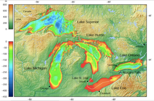
1.Western Lake Erie is the shallowest sub-basin of Lake Erie, which is the shallowest lake of the Great Lakes.
The Great Lakes were created by the Wisconsin glaciation that ended 10,000 to 12,000 years ago. The retreat of the continental ice sheet left a large basin in the region of two fault lines from tectonic plates. One of these fault lines created the basin of Lake Erie and Lake Ontario. Lake Erie is the southern most of the Great Lakes where the continental glacier was relatively thin with less erosive power. The average depth of Lake Erie is only 19 m (62'), compared with average depths of Lake Huron (59 m; 195'), Lake Michigan (85 m; 279'), Lake Ontario (86 m; 283') and Lake Superior (147 m; 483').
The bedrock of the eastern portion of Lake Erie is made of shale, which is softer and more easily eroded by the ice sheet, thus deeper water depths. Western Lake Erie, in contrast, has dolomite and limestone bedrock, which is harder and thus shallower water depths (average depth = 7.6-9.1 m; 25-30').
2. About one-third of the total population of the Great Lakes basin is in the Lake Erie watershed (~12 million), and Lake Erie provides drinking water for about 11 million people.
The population density in the Lake Erie watershed is high, with urban centers like Cleveland (2+ M), Buffalo (1.1+ M) and Toledo (650,000+) directly on the shores of Lake Erie. In addition, Lake St. Clair and the Detroit River, which are between Lakes Huron and Erie just upstream of Lake Erie, has the city of Detroit (4.2+ M) on its shore. Most of the municipalities draw water directly from a Lake Erie for their drinking waster supplies. Thus, the vast majority inhabitants of the Lake Erie watershed depend on adequate water quality, and are especially vulnerable to water quality degradation.
3. Western Lake Erie is the most impacted region within the entire Great Lakes complex, with chronic harmful algal blooms often leading to health advisories.
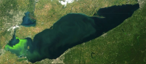
Western Lake Erie has been experiencing chronic harmful algal blooms due to excess nutrients from urban sources (e.g., wastewater discharge and stormwater runoff) and rural sources (e.g., runoff from fertilizer and animal manure). In August, 2014 the Toledo, Ohio public water supply was contaminated by microcystin, a toxin produced by the cyanobacteria (aka blue-green algae) Microcystis. The city issued an advisory to not use the water, and people had to temporarily rely on bottled drinking water. Microcystin toxins can cause liver and kidney damage, in addition to skin rashes and gastrointestinal problems. NOAA uses satellite data and various water quality measurements to provide regular forecasts of cyanobacteria blooms from July to October. In addition to drinking water supplies, harmful algal blooms have led to beach closures.
Phosphorus has been implicated as the nutrient most responsible for excess growth of microalgae and cyanobacteria in freshwater. In contrast, nitrogen is the nutrient most responsible for harmful algal blooms in seawater. However, both nutrients are required by harmful algae and a reduction strategy that targets both nutrients is typically recommended.
4. Lake Erie produces more fish each year for human consumption than the other four Great Lakes combined.
Lake Erie has historically supported active commercial and recreational fisheries. The commercial fishery has been reduced, but the recreational fishery is thriving. Direct competition between commercial and recreational fisheries occurs, and the Great Lakes Fisheries Commission is responsible for setting quotas and catch limits.
The productive waters of Lake Erie support walleye/pickerel, yellow perch, rainbow smelt, white bass and smallmouth bass, among others. There are many introduced species in Lake Erie as well, including alewifes, common carp, and an attempted introduction of coho salmon. There are health advisories on fish consumption due to PCBs.
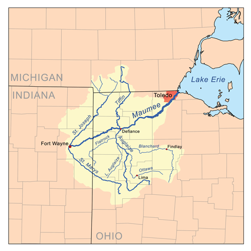
5. The Maumee River, which flows into Western Lake Erie, is the largest watershed in the entire Great Lakes and supports intensive agriculture.
The Maumee River is formed at the junction of the St. Joseph and St. Mary's Rivers and it runs 220 km (137 mi) into the southwest corner of Lake Erie in the city of Toledo, Ohio. The Maumee River watershed includes land in three states; Ohio, Michigan and Indiana. The watershed area of the Maumee River is 21,540 km2 (8,316 mi2) which is two thirds agricultural land, largely corn and soybean rotation. The watershed supports small municipalities (e.g., Fort Wayne, Indiana and Defiance, Lima, & Findlay, Ohio).
The Maumee River watershed supports intensive agriculture, covering over 70% of the watershed. Most of the agricultural land is highly productive row crops, with a small amount of pasture/hay land use and some urban development. The agricultural row crops are largely on a rotation of corn and soy, with no-till practices dominating the practices. There are also confined feeding operations with cattle for beef and dairy, pigs and chickens. Riparian buffers are common practice, but there is little standardization and over half of the buffers are less than 3 m (10') wide.
6. The historic Great Black Swamp in the Maumee River Watershed was drained to make way for agriculture thus reducing the capacity for nutrient retention.
The Great Black Swamp was formed by the last continental glacier as a part of Lake Maumee, the precursor to present day Lake Erie. The swamp lasted from its creation ca. 11,000 years ago during the Wisconsin Glaciation until the 1900s when it was drained. The soils formed in the swamp have become rich agricultural land following draining facilitated by installation of tile drains. These flat, low lying lands formed by drowning the Great Black Swamp are prone to flooding.
7. Management of Lake Erie involves two federal governments (US and Canada), five US states (Indiana, Michigan, New York, Ohio, Pennsylvania), one Canadian province (Ontario), several large municipalities (e.g., Cleveland, Toledo, Erie), numerous NGOs (Lake Erie Foundation, etc.).
Lake Erie has a complex management arrangement, with multiple levels of government involved from two countries. Furthermore, Lake Erie has three distinct basins, each with distinct environmental issues influenced by water depth. The shallow western basin of Lake Erie has chronic harmful algal blooms; the deeper central basin has deep water hypoxia and the shallow coastal regions of the eastern basin has blooms of the filamentous benthic green algae Cladphora blooms.
The International Joint Commission is a joint Canada and United States commission to prevent and resolve disputes between the two countries. It was established by the Boundary Waters Treaty signed by Canada and the United States in 1909. Their mandate includes regulating shared water uses, improving water quality and air quality. The Great Lakes Commission was established in 1955 to "promote economic prosperity and environmental protection" of the Great Lakes. The Commission is comprised of 8 Great Lakes states and the Canadian provinces of Ontario and Quebec. The Great Lakes and St. Lawrence Cities Initiative is composed of mayors of the cities on the Great Lakes and St. Lawrence Seaway. The initiative is dedicated to "protecting the restoring the Great Lakes & St. Lawrence River".
About the author
Bill Dennison

Dr. Bill Dennison is a Professor of Marine Science and Vice President for Science Application at the University of Maryland Center for Environmental Science.