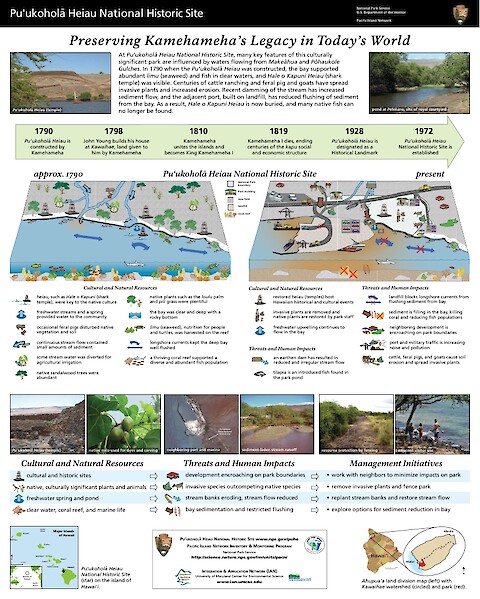
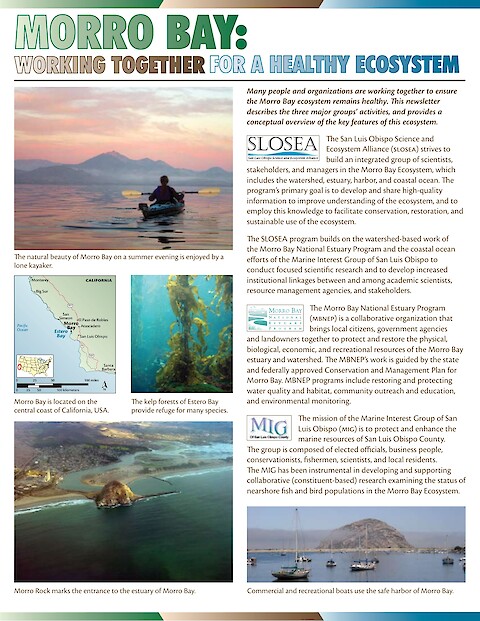
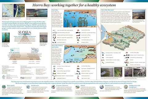
Publications by Jane Hawkey

IAN is committed to producing practical, user-centered communications that foster a better understanding of science and enable readers to pursue new opportunities in research, education, and environmental problem-solving. Our publications synthesize scientific findings using effective science communication techniques.

Pu

Pu'uhonua o Honaunau National Historic Park

Tim Carruthers, Jane Hawkey, Bill Dennison ·

The Pacific Island Network (PACN) of the National Park Service (NPS) Inventory and Monitoring program is currently in the process of implementing vital signs monitoring within 11 PACN parks. As a basis to monitoring, effective communication is essential. This poster features Pu'uhonua o Honaunau National Historic Park on the island of Hawai'i, the location of historical sites, anchialine pools, and rare plants and animals.

Pu

Pu'ukohola Heiau National Historic Site

Tim Carruthers, Jane Hawkey, Bill Dennison ·

The Pacific Island Network (PACN) of the National Park Service (NPS) Inventory and Monitoring program is currently in the process of implementing vital signs monitoring within 11 PACN parks. As a basis to monitoring, effective communication is essential.

Morro Bay: working together for a healthy ecosystem (Page 1)

Morro Bay: working together for a healthy ecosystem

Bill Dennison, Jane Hawkey ·

Morro Bay, on the central California coast, was the site of a workshop to develop a conceptual framework for an ecosystem-based management initiative. IAN staff worked with Morro Bay scientists, resource managers, and stakeholders to develop conceptual diagrams for Morro Bay, offshore Estero Bay and the Morro Bay watershed. These diagrams examined key features, threats, and management objectives of the Morro Bay ecosystem.

An eye-opening approach to developing and communicating integrated environmental assessments (Page 1)

An eye-opening approach to developing and communicating integrated environmental assessments

Dennison WC, Lookingbill TR, Carruthers TJB, Hawkey JM, and Carter SM ·

Communication among managers, the public, and scientists is the key to successful ecosystem management; however, the varied perspectives and interests of these groups can make such communication difficult. One way to achieve effective communication is to develop a common knowledge base by combining syntheses of key scientific results with information-rich visual elements.

National Capital Region Network Regional Overview (Page 1)

National Capital Region Network Regional Overview

Jane Hawkey, Tim Carruthers, Bill Dennison ·

This poster series outlines the work of the National Capital Region Network's (NCRN) Inventory and Monitoring Program. The program's role is to monitor the status and trends of the parks, their vital signs and development pressures. Park vital signs monitoring is designed to inform managers of the condition of water, air, plants and animals, and the various ecological, biological, and physical processes that act on those resources.

Antietam National Battlefield (Page 1)

Antietam National Battlefield

Jane Hawkey, Tim Carruthers, Bill Dennison ·

Antietam National Battlefield is managed within the historical context of General Robert E. Lee's first invasion of the North during the Civil War. The 1,926 acre park is located in the heart of Maryland and is surrounded by rolling hills dotted with farm fields and pastures reminiscent of the day of battle. Patches of forest, open meadow, streams, and cropland are found within the park.

Catoctin Mountain Park (Page 1)

Catoctin Mountain Park

Jane Hawkey, Tim Carruthers, Bill Dennison ·

Catoctin Mountain Park originated as a Recreation Demonstration Area in 1936 and is managed today for its recreational use and the conservation of its cultural and natural resources. The park encompasses 5,810 acres of mixed hardwood forest located in the mountains of the Catoctin Ridge in north-central Maryland. Two high-quality streams bisect the park and the unique three million year old geology forms a number of cliffs and scenic vistas.

Chesapeake & Ohio Canal National Historical Park (Page 1)

Chesapeake & Ohio Canal National Historical Park

Jane Hawkey, Tim Carruthers, Bill Dennison ·

The Chesapeake & Ohio Canal National Historical Park is the largest and longest park in the National Capital Region, stretching along the Potomac River for 184.5 miles from Washington, DC to Cumberland, MD. The park's 19,236 acres cut through four major physiographic provinces and include diverse wetlands, floodplain, and upland forests. Hundreds of historic structures are preserved as reminders of the Canal's role as a major transportation system during the Canal Era.

George Washington Memorial Parkway (Page 1)

George Washington Memorial Parkway

Jane Hawkey, Tim Carruthers, Bill Dennison ·

George Washington Memorial Parkway was established to protect the scenic views along the Potomac River and its tributaries in the Washington, DC area. The park's 7,210 acres provide habitat for dozens of state-listed species of rare, threatened, or endangered plants and animals, many of which are associated with rare plant communities of the Potomac River Gorge.