IAN is committed to producing practical, user-centered communications that foster a better understanding of science and enable readers to pursue new opportunities in research, education, and environmental problem-solving. Our publications synthesize scientific findings using effective science communication techniques.

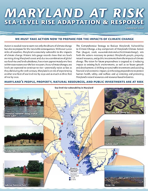
Maryland at Risk: Sea-level rise adaptation & response (Page 1)

Maryland at Risk: Sea-level rise adaptation & response

Jane Thomas ·

Action is needed now to stem not only the drivers of climate change but also to prepare for the inevitable consequences. With over 3,000 miles of coastline, Maryland is extremely vulnerable to the impacts of climate change. Historic tide-gauge records reveal that sea levels along Maryland's extensive coastline have risen approximately one foot over the past one hundred years. This relative sea level rise is due to a combination of global sea-level rise and localized land subsidence.

Upstream land use affects water quality in Maryland

Upstream land use affects water quality in Maryland's Coastal Bays

Kris Beckert, Ben Fertig, Tim Carruthers, Bill Dennison, Emily Nauman ·

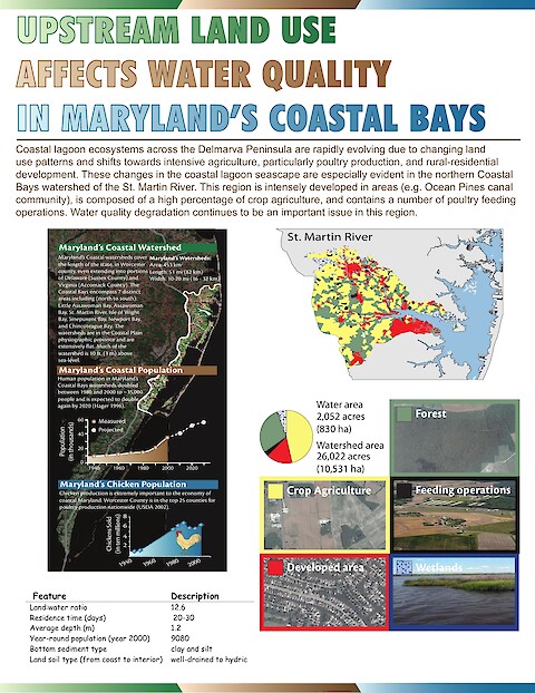
Coastal lagoon ecosystems across the Delmarva Peninsula are rapidly evolving due to changing land use patterns and shifts towards intensive agriculture, particularly poultry production, and intensive rural-resiĀ­dential development. These changes in the coastal lagoon seascape are especially evident in the northern Coastal Bays watershed of St. Martin River.

Reef Plan Monitoring: Marine Water Quality Impacts (Page 1)

Reef Plan Monitoring: Marine Water Quality Impacts

Bill Dennison, Ben Longstaff, Jane Thomas ·

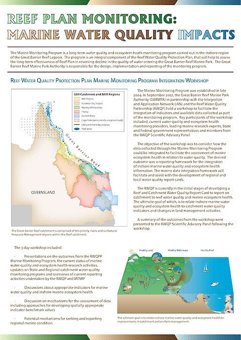
The Marine Monitoring Program is a long-term water quality and ecosystem heath monitoring program carried out in the inshore region of the Great Barrier Reef Lagoon. The program is an integral component of the Reef Water Quality Protection Plan, that will help to assess the long-term effectiveness of Reef Plan in reversing decline in the quality of water entering the Great Barrier Reef Marine Park.

A summer of poor water clarity, algal blooms, and fish kills (Page 1)

A summer of poor water clarity, algal blooms, and fish kills

Ben Longstaff, Emily Nauman, Caroline Donovan, Bill Dennison, David Jasinski ·

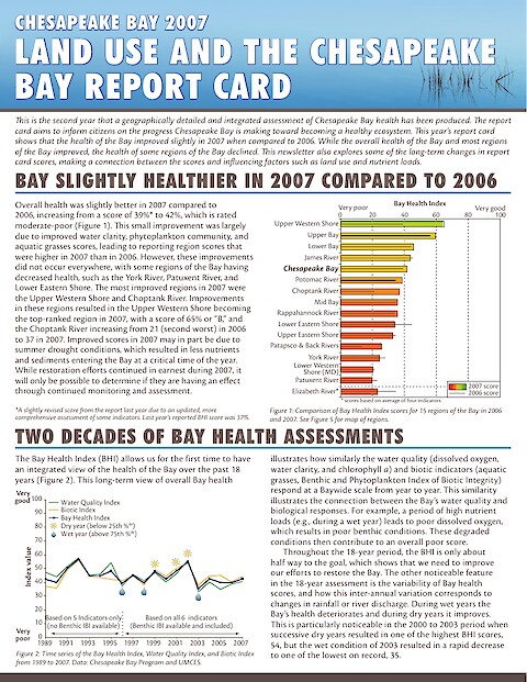
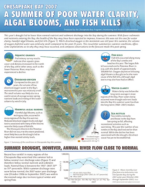
This year's drought led to lower than normal nutrient and sediment discharge into the Bay during the summer. With fewer sediments and nutrients entering the Bay, the health of the Bay may have been expected to improve, however, this was not the case for water clarity, harmful algal blooms, and fish kills. While dissolved oxygen in the mainstem was still poor this summer, the volume of oxygen depleted water was relatively small compared to the past 22 years.

Incorporating habitat into ecosystem-based fisheries management: Habitat matters! (Page 1)

Incorporating habitat into ecosystem-based fisheries management: Habitat matters!

Wicks EC, Boicourt K, Longstaff BJ and Townsend H ·

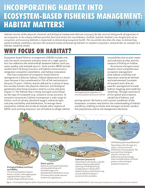
Habitat consists of the physical, chemical, and biological components that are necessary for the survival and growth of organisms in an ecosystem. In an estuary, habitat provides food and shelter for invertebrates, shellfish, and fish. Habitat is an integral part of an ecosystem, and assessing habitats is important in determining ecosystem health.

Asian oysters: Science to inform policy decisions (Page 1)

Asian oysters: Science to inform policy decisions

O'Herron M, King J, Wicks EC, Bushek D and Carnegie R ·

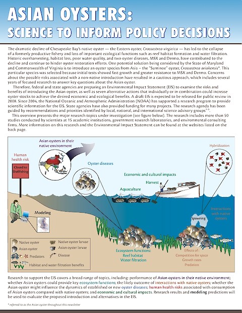
This is a three part series on the Asian oyster Environmental Impact Statement. It has been proposed to introduce the Asian oyster (Crassostrea ariakensis) into Chesapeake Bay as one potential solution to the loss of the historic oyster fishery, and the ecological functions that oysters perform for Chesapeake Bay.

Protecting Palau

Protecting Palau's natural heritage

Bill Dennison, Ben Longstaff, Jane Thomas ·

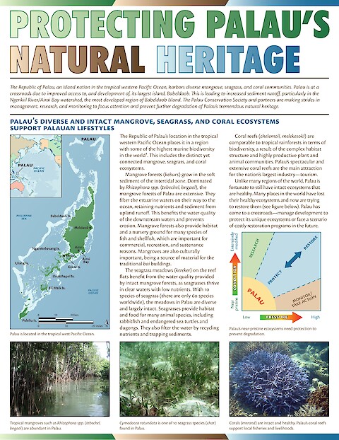
The Republic of Palau, an island nation in the tropical western Pacific Ocean, harbors diverse mangrove, seagrass, and coral communities. Palau is at a crossroads due to improved access to, and development of, its largest island, Babeldaob. This is leading to increased sediment runoff, particularly in the Ngerikiil River/Airai Bay watershed, the most developed region of Babeldaob Island.